
Hour-by-hour winter storm projections, totals in south-central Pennsylvania
CHRISTMAS. IT IS 646 TODAY. WE HAVE AN EASY WEATHER DAY. WE SHOULD GET INTO THE UPPER 40S FOR OUR HIGHS. WE’LL SEE A MIX OF CLOUDS AND SUNSHINE LATER, BUT THEN THE WEATHER TURNS A BIT MORE SERIOUS ON FRIDAY, SO LET’S TALK ABOUT IT ON FRIDAY. WE HAVE A WINTER STORM WATCH IN EFFECT FOR THE SUSQUEHANNA VALLEY. ALL COUNTIES INCLUDED UNDER THIS WATCH ON FRIDAY AFTERNOON. I’D SAY RIGHT AFTER LUNCHTIME WE SHOULD START TO SEE THAT WINTRY MIX DEVELOPING, ESPECIALLY IN WESTERN AND NORTHWESTERN COUNTIES. SO THIS IS AT 1 P.M. ON FRIDAY. BY THE TIME WE HIT 3 P.M. LOOK AT HOW FAST THAT CHANGES. THIS MIX MOVES EAST. NOW THE MIX COULD INCLUDE SOME LIGHT SNOW TO BEGIN WITH, BUT I THINK THE MAJORITY OF THIS IS GOING TO BE SLEET. SNOW, SLEET WILL BE FALLING ON FRIDAY AFTERNOON AND CONTINUES INTO FRIDAY EVENING. FREEZING RAIN MAY EVEN MIX IN, SO IT MAY LOOK LIKE IT’S RAINING, BUT THE SURFACE TEMPERATURES ARE GOING TO BE BELOW FREEZING, SO THAT FREEZES ON CONTACT. THAT CONTINUES ALL EVENING INTO THE NIGHT ON FRIDAY. BUT AS SOON AS WE HIT MIDNIGHT, I’M STARTING TO SEE THE PRECIPITATION TAPER. SO I DO THINK IT TAPERS IN THE WEE HOURS OF SATURDAY. BY THE TIME WE HIT 3:04 A.M. SATURDAY, IT’S OUT OF HERE. BUT THE IMPACTS REMAIN BECAUSE TEMPERATURES, THEY’RE GOING TO BE IN THE 20S ON SATURDAY MORNING. SO ANY UNTREATED SURFACE WILL STILL BE ICY. HERE’S A LOOK AT OUR PREDICTOR. SNOW AND SLEET ACCUMULATION. SO THOSE ADDED TOGETHER NOT A LOT, BUT ENOUGH TO MAKE THINGS SLICK. NOW AS FAR AS THE FREEZING RAIN IS CONCERNED, WE COULD SEE A 10TH OF AN INCH TO UP TO 2/10 OF AN INCH OF FREEZING RAIN. SO JUST KIND OF ENCASING EVERYTHING IN ICE, IT’S GOING TO BE VERY DIFFICULT. TRAVEL, I THINK LATE ON FRIDAY INTO FRIDAY NIGHT. SO IF YOU CAN GET TO WHERE YOU NEED TO GO BY FRIDAY AFTERNOON, YOU SHOULD BE IN PRETTY GOOD SHAPE TODAY. NEWS EIGHT STORM TEAM FORECAST FOR THIS CHRISTMAS CALLS FOR JUST A COUPLE OF SHOWERS IN THE MORNING. THEN WE SEE CLEARING SKIES. PARTLY SUNNY, 48 COULD TAKE A RUN AT THE 50 DEGREE MARK TODAY WITH WINDS DIMINISHING AS WE HEAD TOWARD TONIGHT. OVERNIGHT 24 TO 28 DEGREES. IT GETS COLD TONIGHT AND THEN FOR TOMORROW WE ONLY HIT THE FREEZING MARK. WE SHOULD SEE INCREASING AND THICKENING CLOUDS AROUND SUNRISE. AND THEN THAT MIX DEVELOPING BETWEEN 1 P.M. AND 5 P.M. IN THE AFTERNOON. SO HERE’S OUR CURRENT. IT’S 34 DEGREES IN LEWISTOWN. WE HAVE A PAIR OF THREES IN LANCASTER. GOOD MORNING. IN YORK YOU’RE AT 35. SAME FOR LEBANON AND HARRISBURG WITH WIND SPEEDS AROUND 5 TO 10 5 TO 15 A COUPLE OF SHOWERS. THEY’RE ALMOST OUT OF HERE. WE’VE HAD SOME SPOTTY SHOWERS THROUGH FRANKLIN, CUMBERLAND, ADAMS, YORK COUNTIES. AND THEY’RE JUST ABOUT DONE. LOW PRESSURE IS QUICKLY ZIPPING BY TO OUR SOUTH. EVEN SOME LIGHTNING WITH THAT ACROSS WEST VIRGINIA. AND THAT IS GOING TO BE HEADED WELL TO OUR SOUTH LATER TODAY. ENERGY FOR OUR NEXT STORM OVER THE WEST COAST. SO THAT IS WHAT’S GOING TO BRING US THE WINTRY MIX TOMORROW. TODAY THOUGH, YOU DON’T HAVE A WEATHER WORRY IN THE WORLD. LOOK AT THAT NICE CLEAR SKIES THIS AFTERNOON. A LITTLE BREEZY, BUT STILL MILD FOR CHRISTMAS TONIGHT INTO TOMORROW MORNING, CLOUDS THICKEN AND HERE COMES THAT WINTRY MIX THROUGH TOMORROW AFTERNOON AND TOMORROW EVENING. EXPECT SOME SLOW, SLICK TRAVEL LATE IN THE DAY. VERY ICY FOR SATURDAY. IT’S OUT OF HERE. WE SEE CLOUDS HANGING TOUGH THOUGH, AND THAT’S GOING TO LOCK IN THE COLD. SO SATURDAY IS AN IMPACT DAY BECAUSE IT STILL WILL BE ICY IN THE MORNING ON ANY UNTREATED SURFACE. SUNDAY. SOME SHOWERS ROLL IN LATE. I SEE MONDAY BEING QUITE WARM AHEAD OF A STRONG COLD FRONT, AND THAT’S GOING TO KNOCK US DOWN INTO THE 30S ON TUESDAY, WEDNESDAY, THURSDAY, FRIDAY INTO THE NEW YEAR.
Hour-by-hour winter storm projections, totals in south-central Pennsylvania

Updated: 8:09 AM EST Dec 25, 2025
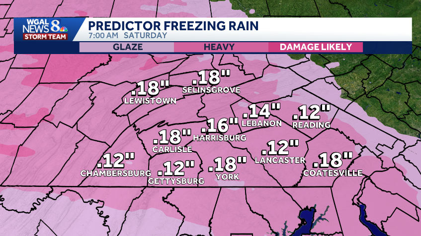
A winter storm is set to move through south-central Pennsylvania, making Friday an Alert Day as a wintry mix develops, and Saturday an Impact Day as untreated roads will still be icy in the morning. We’ve posted the latest hour-by-hour projections and the snowfall accumulation map in the video player above.A Winter Storm Watch was issued by the National Weather Service to all of the Susquehanna Valley from Friday morning through Saturday morning. Hour-by-hour projectionsFriday: Early afternoon: Wintry mix arrives west to east, between 1 p.m. to 5 p.m. It will start as light snow. Late afternoon: Roads begin to worsen, travel conditions become slick and icy. Evening: Sleet and freezing rain for most areas. Icy and hazardous travel.Night: Sleet and freezing rain taper. Temperatures fall to the upper 20s. Saturday:Around 3 a.m.: Wintry precipitation ends.By sunrise: Dry across the area.Morning: Lingering icy roads, slick travel conditions. Early afternoon: Lingering slick spots. Rest of the day: Dry, mostly cloudy, and cold with highs around 34 degrees. TotalsSnow and sleet accumulation: Coating to two inches. Ice and freezing rain: 0.10 to 0.20 inches. Did you capture the winter storm and would like to share with News 8? Send us your photos or videos at https://www.wgal.com/upload.Stay weather aware with WGAL’s online toolsRADAR: Track severe weather with WGAL’s interactive radar.LOCATION-BASED ALERTS: Instructions for activating our customized weather alerts are here.CLOSINGS: When severe weather strikes, see if businesses, churches or organizations have closed or delayed.ROAD CLOSURES: Our interactive traffic map is always updated with crashes, construction and road closures. It even has a weather radar overlay.EMAIL ALERTS: We’ll send you daily updates, or just alerts when severe weather is headed your way.HOUR-BY-HOUR: See what you can expect every day with the hourly forecast.WEEKEND WEATHER: Know what to expect before you make your plans.10-DAY FORECAST: Check WGAL’s extended forecast here.
A winter storm is set to move through south-central Pennsylvania, making Friday an Alert Day as a wintry mix develops, and Saturday an Impact Day as untreated roads will still be icy in the morning.
We’ve posted the latest hour-by-hour projections and the snowfall accumulation map in the video player above.
A Winter Storm Watch was issued by the National Weather Service to all of the Susquehanna Valley from Friday morning through Saturday morning.
Hour-by-hour projections
Friday:
Early afternoon: Wintry mix arrives west to east, between 1 p.m. to 5 p.m. It will start as light snow. Late afternoon: Roads begin to worsen, travel conditions become slick and icy. Evening: Sleet and freezing rain for most areas. Icy and hazardous travel.Night: Sleet and freezing rain taper. Temperatures fall to the upper 20s.
Saturday:
Around 3 a.m.: Wintry precipitation ends.By sunrise: Dry across the area.Morning: Lingering icy roads, slick travel conditions. Early afternoon: Lingering slick spots. Rest of the day: Dry, mostly cloudy, and cold with highs around 34 degrees. Totals
Snow and sleet accumulation: Coating to two inches.
Ice and freezing rain: 0.10 to 0.20 inches.
Did you capture the winter storm and would like to share with News 8? Send us your photos or videos at https://www.wgal.com/upload.