
Today is a Severe Weather Alert Day for treacherous travel due to freezing rain changing to rain. Most of our area is just seeing rain. Spots north and east will see prolonged freezing rain through this evening.Severe Weather Alert Day: Icy conditionsPrecipitation continues to fill in around western Pennsylvania. The change to all rain with isolated pockets of freezing rain for areas south of US-422 this afternoon. Some slick spots on bridges, overpasses, and untreated surfaces are possible.The more dangerous icing will happen north of US-422 and into the Laurel Highlands. The freezing rain could last into this evening, causing heavy ice accretion leading to dangerous travel conditions and possible power outages from power line and tree limb damage.Winter weather alertsAn Ice Storm Warning is in effect through 7 a.m. Saturday for Armstrong, Clarion, Forest, Indiana, Venango, and the ridges of Westmoreland counties. Higher ice accretions are expected here.Allegheny, Beaver, Butler, the ridges of Fayette, Lawrence, Washington, and western Westmoreland counties go under a Winter Weather Advisory that will remain in effect through late-day. A glaze of ice is enough to make roads slick and icy. Quiet Saturday; More rain SundaySunday brings another system to Western PA with rain showers through most of the day. The rain could be heavy at times during the afternoon, especially north of Pittsburgh. Monday starts with rain but temperatures will drop as the cold front passes in the morning. Monday is an Impact Day. Rain will transition to a brief burst of snow. Snow accumulations of less than an inch are possible.Dropping temperatures to end 2025Following Monday’s Impact Day, temperatures will stay cold. Highs will only be in the 20s for the final days of the year. Snowflakes will fly with the confetti to ring in 2026. A snow shower or two are also possible on New Year’s Day with temperatures struggling to reach freezing.TODAY – Severe Weather Alert Day: Rain around Pittsburgh, staying icy north and east. High: 48°.TONIGHT: Drying out this evening. Slick or icy roads possible. Low: 35°.SATURDAY: Quiet, chilly, and mostly cloudy. High: 40°, low: 33°.SUNDAY: Warmer with rain showers developing. High: 59°, low: 34°.MONDAY – Impact Day: Rain changes to snow as temperatures plummet. Windy with wind chills in the teens. Morning temperature around 50 degrees, near freezing by the evening.
PITTSBURGH —
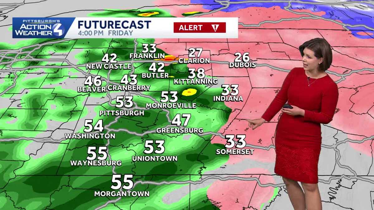
Today is a Severe Weather Alert Day for treacherous travel due to freezing rain changing to rain. Most of our area is just seeing rain. Spots north and east will see prolonged freezing rain through this evening.
Severe Weather Alert Day: Icy conditions
Precipitation continues to fill in around western Pennsylvania. The change to all rain with isolated pockets of freezing rain for areas south of US-422 this afternoon. Some slick spots on bridges, overpasses, and untreated surfaces are possible.

Hearst OwnedHearst
Widespread rain or freezing rain (north and east) this afternoon.
The more dangerous icing will happen north of US-422 and into the Laurel Highlands. The freezing rain could last into this evening, causing heavy ice accretion leading to dangerous travel conditions and possible power outages from power line and tree limb damage.

Hearst OwnedHearst
The highest impacts from the ice storm will be north of US-422 and in the ridges. Ice accretions will disrupt travel and could cause scattered power outages.
Winter weather alerts
An Ice Storm Warning is in effect through 7 a.m. Saturday for Armstrong, Clarion, Forest, Indiana, Venango, and the ridges of Westmoreland counties. Higher ice accretions are expected here.

Hearst OwnedHearst
Ice Storm Waring and Winter Weather Advisory for almost all of western PA for periods of freezing rain.
Allegheny, Beaver, Butler, the ridges of Fayette, Lawrence, Washington, and western Westmoreland counties go under a Winter Weather Advisory that will remain in effect through late-day. A glaze of ice is enough to make roads slick and icy.
Quiet Saturday; More rain Sunday
Sunday brings another system to Western PA with rain showers through most of the day. The rain could be heavy at times during the afternoon, especially north of Pittsburgh. Monday starts with rain but temperatures will drop as the cold front passes in the morning. Monday is an Impact Day. Rain will transition to a brief burst of snow. Snow accumulations of less than an inch are possible.

Hearst OwnedHearst
Monday’s Impact Day is rain changing to snow, a sharp drop in temperature, wind gusts, and wind chills in the teens.
Dropping temperatures to end 2025
Following Monday’s Impact Day, temperatures will stay cold. Highs will only be in the 20s for the final days of the year. Snowflakes will fly with the confetti to ring in 2026. A snow shower or two are also possible on New Year’s Day with temperatures struggling to reach freezing.

Hearst OwnedHearst
Temperatures sharply drop Monday, which is an Impact Day. Confetti and light snow will fall to ring in 2026.
TODAY – Severe Weather Alert Day: Rain around Pittsburgh, staying icy north and east. High: 48°.
TONIGHT: Drying out this evening. Slick or icy roads possible. Low: 35°.
SATURDAY: Quiet, chilly, and mostly cloudy. High: 40°, low: 33°.
SUNDAY: Warmer with rain showers developing. High: 59°, low: 34°.
MONDAY – Impact Day: Rain changes to snow as temperatures plummet. Windy with wind chills in the teens. Morning temperature around 50 degrees, near freezing by the evening.