
SHORT TERM FORECAST
CHRISTMAS DAY: A cloudy start, possibly a flurry or a sprinkle; turning out rather sunny and pleasant by the afternoon. High: 44
THURSDAY NIGHT: Partly cloudy and cold. Low: 20
FRIDAY: Starting quiet but turning messy. Expect snow and ice to be around for the afternoon and evening. Plan for messy and slick travel. High: 29
FORECAST SUMMARY
Christmas Day gets off to a little bit of a cloudy start with a brief sprinkle or flurry around early AM, however as the day wears on things turn out rather sunny. Things take a turn for messy as we get into our Friday. A wintry mix of snow, sleet, and some freezing rain will arrive later Friday afternoon and last into early Saturday morning. Several inches of snow and sleet can be expected across the region through this period along with a tenth to two tenths of an inch of ice in some spots. In the wake of that system, our weekend will remain rather cloudy but dry for a while later Saturday into a good chunk of Sunday before just plain old rain returns late Sunday into Sunday night. In the wake of that storm system, a stretch of blustery and cold weather looks to take shape that will likely ring in 2026. It doesn’t look like there are any big storms to go along with that cold though at this point…at least next week.
DETAILED FORECAST
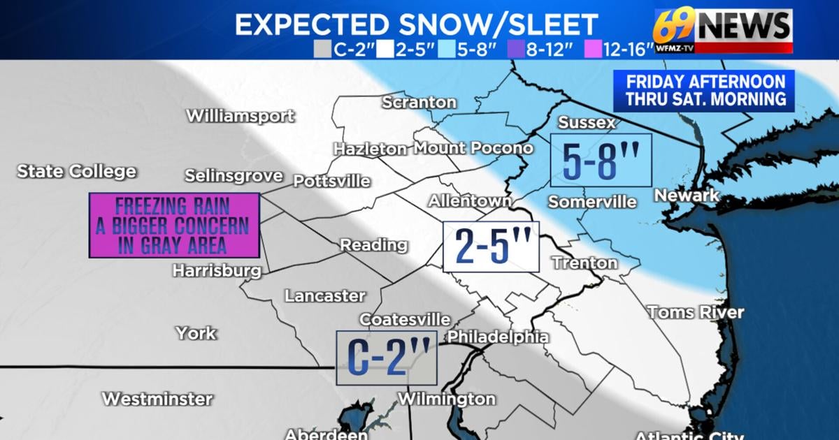
***WINTER STORM WATCH IN EFFECT FOR MOST OF THE REGION FROM FRIDAY AFTERNOON THROUGH SATURDAY MORNING***
CHRISTMAS DAY
Christmas Day, a weak disturbance will pass by to our south, the reason for our clouds. A few sprinkles or flurries out early for our Christmas morning, but nothing that will have any impact on the rest of the day. We will start cloudy Christmas morning followed by mostly sunny skies in the afternoon. High temperatures should reach the mid 40s and the winds will be much lighter compared to Wednesday.
FRIDAY AND FRIDAY NIGHT
Friday continues to look to be a more impactful winter weather day, as cold air presses down from Canada to our north, and meets up with plenty of moisture riding along a weather frontal boundary. That means snow will likely develop later Friday afternoon, but it may not just be snow, but also sleet and freezing rain that could accumulate across much of the area later Friday into Friday night. While accumulations are likely, how much snow vs sleet vs freezing rain continues to be a bit of a forecast challenge. So here is our latest thinking:
For many, the precipitation is expected to start out as all snow moving in from west to east roughly between 3pm and 6pm on Saturday. That initial round of snow could pick up in intensity fairly quickly. Then roughly between 8pm and midnight, we anticipate a change to sleet from west to east with the change to sleet probably stopping somewhere near the Delaware River. This sleet will likely continue for an extended period of time overnight Friday before tapering off early Saturday morning, probably before 10am. Some freezing rain (plain rain falling from the sky that freezes on contact with sub-freezing surfaces creating layers of ice) may also mix in with the sleet Friday night into Saturday morning. The further south and west one travels from the I-78 corridor, the better your odds will be to see that freezing rain. At this time, ice totals likely will be on the order of 0.10″ to 0.20″ and again, the further south and west one travels from the I-78 corridor, the greater the amounts would be. Now as for expected snow/sleet totals, for much of the Lehigh Valley, Berks, Schuylkill County, Bucks and Montgomery Counties, the Delaware Valley, southwestern New Jersey, and even the western Poconos closer to I-476 and I-81, we anticipate 2 to 5 inches of accumulation with sleet and possibly some freezing rain keeping totals from getting higher than 5 inches. If some of these areas do manage to remain mostly all snow, then totals could possibly exceed 5 inches. For those in the Slate Belt region, eastern Poconos…certainly Monroe and Pike County, and a lot of central and northern New Jersey, we anticipate the precipitation to stay mainly all snow and hence the greatest totals on the order of 5 to 8 inches are expected here. Temperatures during this storm system will be below freezing in most locations, mainly in the 20s and certainly no warmer than 30 degrees. So whatever precipitation falls will definitely stick and road conditions and untreated surfaces will certainly have deteriorating conditions by Friday evening through much of the overnight into first thing Saturday morning.

THIS WEEKEND
Saturday looks to be a drier “in-between” day, with plenty of clouds, chilly temps mostly in the 30s, and perhaps some lingering snow, sleet, and freezing rain/freezing drizzle. However, by the afternoon things should just be dry and cloudy. Come Sunday, another cold front approaches, but we’ll briefly get into some milder air with highs in the 40s ahead of this front, which means it will be all rain showers this time around arriving late in the day and becoming steadier and heavier Sunday night. Colder, windy, and drier weather will follow early next week.
EARLY NEXT WEEK
One (or more) shots of arctic air look to settle in next week, one early in the week to round out 2025, and one late in the week to start off 2026. Expect cold and windy weather, but also mostly dry weather, when the arctic air is here. Highs could remain in the upper 20s and low 30s, with colder wind chills and colder nighttime lows in the teens.
Download the FREE 69News Traffic App
TRACK THE WEATHER:
LINKS: HOUR BY HOUR | RADAR | TRAFFIC