
ALERT DAY: Sleet & freezing rain expected this evening across south-central Pennsylvania
Road conditions and surfaces are deteriorating this evening, and travel will be icy through early Saturday. More rain showers are expected heading into early next week.
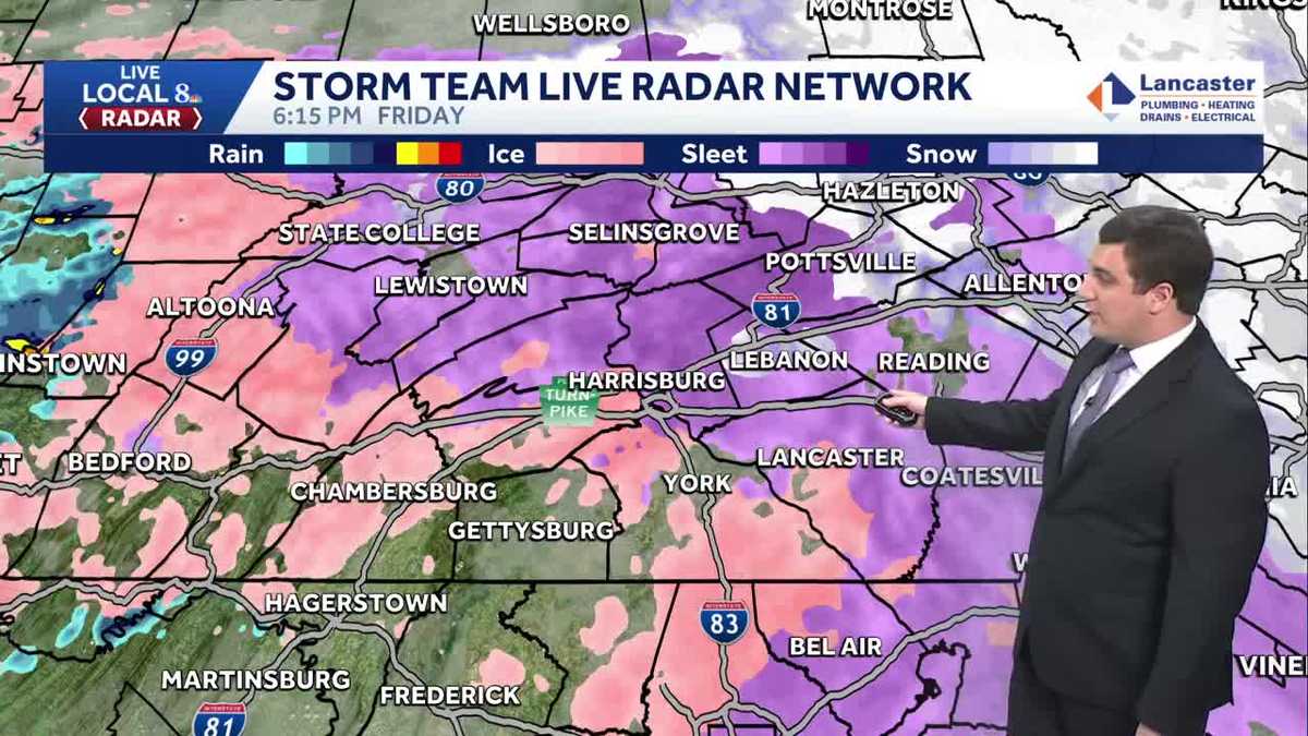
WELL, GOOD EVENING EVERYONE. WE’RE STILL TRACKING THAT WINTRY MIX HERE ACROSS THE SUSQUEHANNA VALLEY, INCLUDING IN CARLISLE RIGHT NOW, WHERE IT’S ACTUALLY COMING DOWN PRETTY GOOD HERE IN PARTS OF THE AREA. WE LITERALLY ABOUT 30S AGO JUST GOT SOME REPORTS FROM THE NATIONAL WEATHER SERVICE, THOMASVILLE AND YORK HAS ALREADY PICKED UP THREE HUNDREDTHS OF AN INCH OF ICE. SAME THING IN STEELTON AT 400TH OF AN INCH OF ICE. AND IN LITITZ YOU PICKED UP 100TH OF AN INCH OF ICE. SO FAR, SO GOOD REASON WHY TEMPERATURES RIGHT NOW ARE AROUND 28 DEGREES IN THE SUSQUEHANNA VALLEY. AND THAT IS ALLOWING ANYTHING THAT FALLS TO FREEZE ON CONTACT. SO THERE’S THE PURPLE AND PINK THERE ON THE MAP YOU CAN SEE THAT WE ARE STILL SEEING THAT WINTRY MIX ACROSS THE AREA HERE. AND THAT WILL CONTINUE AS WE HEAD INTO THE EVENING. SO SAME THING UP IN LEWISTOWN, PORT ROYAL THERE ALONG 22 AND HIGHWAY 11. WE ARE SEEING THAT WINTRY MIX, SO JUST MAKE SURE YOU’RE BEING CAREFUL IF YOU’RE GOING TO BE HEADING OUT THIS EVENING, MAYBE A LITTLE BIT. SNOWFLAKES TRYING TO MIX IN IN PARTS OF THE HIGHER ELEVATIONS OF NORTHERN DAUPHIN AND LEBANON COUNTY, BUT OTHERWISE YOU’RE DEALING WITH MOSTLY SLEET AND FREEZING RAIN AS WELL. LANCASTER DOWN TO QUARRYVILLE HOLTWOOD OUT TOWARDS GAP. WE’RE ALSO SEEING THAT FREEZING RAIN AND SLEET AT THE MOMENT. SHREWSBURY AND REDLINE GETTING A LITTLE BIT OF THAT FREEZING RAIN. GETTYSBURG AT THE MOMENT, GETTING A LITTLE BIT OF A BREAK. IT LOOKS LIKE, AT LEAST ACCORDING TO THE RADAR HERE. AND SAME THING IN BENDERSVILLE. BUT NOTICE OFF IN FRANKLIN COUNTY YOU’LL HAVE SOME MORE OF IT. COME ON THROUGH HERE. IT’S GOING TO START UP AGAIN FOR YOU IN CHAMBERSBURG AND WAYNESBORO IF IT HASN’T ALREADY. SAME THING IN GREENCASTLE. SO THIS CONTINUES AS WE GO THROUGH THE EVENING AND OVERNIGHT HOURS HERE. EXPECT THE ICY ROAD CONDITIONS TO CONTINUE AS WELL TOMORROW MORNING. EVEN THOUGH THE PRECIPITATION WILL STOP BY MIDNIGHT. THE PROBLEM IS TEMPERATURES DON’T GO ABOVE FREEZING UNTIL TOMORROW AFTERNOON, SO SPOTTY SLICK SPOTS ARE STILL POSSIBLE ON SATURDAY MORNING, EVEN ESPECIALLY IF THERE’S A SPOT THAT’S UNTREATED. SO THAT’S REALLY WHEN YOU WATCH OUT FOR BECAUSE TEMPERATURES FOR EVERYBODY HERE ON THIS MAP YOU CAN SEE ARE IN THE 20S OR LOW 30S. SO ANYTHING THAT FALLS, IT’S FREEZING ON CONTACT AGAIN, ESPECIALLY IF IT’S UNTREATED. YOU’VE BEEN SEEING THE CARS FROM OUR REPORTERS ALL EVENING HERE AND HOW THEY’RE STARTING TO GET THAT CASING OF ICE. AND IF YOU STEP OUTSIDE FOR YOUR CAR, THAT’S GOING TO LIKELY BE THE SAME SITUATION. BUT ALL THIS MOVES OUT AGAIN BY MIDNIGHT. SO WE SHUT THE PRECIPITATION OFF HERE BY MIDNIGHT TONIGHT. IT’S AT THAT POINT JUST BECOMES THE TEMPERATURE GAME HERE WHERE WE’RE WATCHING FOR THOSE TEMPERATURES TO JUMP ABOVE FREEZING. AND IT LOOKS LIKE THAT MAY TAKE A LITTLE BIT. IN ADDITION TO WHAT WE’VE ALREADY PICKED UP. WE’RE TALKING AROUND ANOTHER 500 TO A 10TH OF AN INCH OF ICE EXPECTED ACROSS PARTS OF THE SUSQUEHANNA VALLEY. AGAIN, THAT’S IN ADDITION TO WHAT’S ALREADY FALLEN IN SPOTS. SO IT DOES LOOK LIKE WE’RE GOING TO BE SEEING AROUND THAT 10TH OF AN INCH OF ICE ACCUMULATION BY THE END OF THIS. FOR MOST AREAS, FREEZING DRIZZLE CONTINUES HERE AS WE GO THROUGH THE EVENING HOURS AND THEN OVERNIGHT TONIGHT, 3026 TO 32 DEGREES WILL FOR THOSE LOWS. SO NOT GOING TO BE SEEING MUCH MELTING OVERNIGHT TONIGHT HERE AS THIS SYSTEM PULLS AWAY TOMORROW MOSTLY CLOUDY. IT WILL BE A SLICK START TO THE DAY HERE. AND WE’LL TAKE A LITTLE BIT FOR THOSE TEMPERATURES TO GET ABOVE FREEZING. AND FOR MORE ON WHEN WE CAN SEE THE TEMPERATURES GET ABOVE FREEZING, LET’S GO OVER TO RYAN ARGENTI FOR THAT. RYAN. YEAH, ABSOLUTELY. SO WE’RE GOING TO BE SEEING TEMPERATURES LIKE MIKE WAS TALKING ABOUT. THEY’RE GOING TO BE REMAINING IN THE LOWER 30S. LET ME SHOW YOU OUR TEMPERATURE VERSUS WINDCHILL MAP HERE OR OUR GRAPH HERE. YOU CAN SEE TEMPERATURES RIGHT INTO THE LOWER 30S BY 8:00 AND 10:00 IN THE MORNING. THAT’S NOT REALLY GOING TO BE ALLOWING FOR ANY THAT ICE TO REALLY MELT UNTIL WE GET TO THE MIDDLE OF THE AFTERNOON. YOU CAN SEE BY 12 AND 2:00 IN THE AFTERNOON, FINALLY HITTING RIGHT AROUND THAT 35, 36 DEGREE MARK. THAT’S WHEN WE’LL START TO SEE SOME OF THOSE CONDITIONS IMPROVE. SO AS WE GET INTO OUR SUNDAY, WE MAINLY CLOUDY LOOKING AT SOME LATE DAY SHOWERS THOUGH REMAINING CHILLY 32 TO 36 DEGREES FOR THE SECOND HALF OF THE WEEKEND. BUT JUST PLANNING AHEAD FOR THE PENN STATE FOOTBALL GAME. WE KNOW SOME PEOPLE ARE GOING TO BE HEADED TO THIS GAME. COULD BE SEEING SOME RESIDUAL LIGHT SNOW FOR THE MORNING TIME, BUT THEN BY KICKOFF AND HEADING HOME. THE SYSTEM THAT’S COMING THROUGH NOW, THAT’S ALLOWING FOR SNOW TO BE GOING OR TO TO TO HAPPEN IN NEW YORK. RIGHT. THAT’S GOING TO HAVE MOVED OUT BY THE AFTERNOON AND THE EVENING BECOMING PARTLY CLOUDY BY 5:00. SO LET’S TIME OUT THE SYSTEM, THAT SYSTEM IS ALREADY MOVED OUT BY THE TIME WE MAKE IT TO SATURDAY EVENING. STILL SEEING SOME MOSTLY CLOUDY CONDITIONS. SUNDAY MORNING WE START MOSTLY CLOUDY AND TRACKING THIS NEXT SYSTEM THAT’S GOING TO COME THROUGH AND GIVE US OUR NEXT BEST CHANCE OF SHOWERS, WHICH IS GOING TO BE WHAT’S COMING UP NEXT FOR THE WEEKEND. AND AGAIN, THE TIMING HERE IS SUNDAY EVENING THROUGH THE MIDDAY MONDAY RAIN SHOWERS WITH A BRIEF MIX POSSIBLY NORTH OF THE OF THE TURNPIKE ON THE ONSET, BUT MODERATE TO BRIEF. HEAVY RAIN IS POSSIBLE, WITH ABOUT A QUARTER TO HALF INCH OF TOTAL ACCUMULATION AS WE GET INTO OUR SUNDAY. SO MONDAY, LOOKING AT THAT MORNING RAIN THEN TURNING WINDY. TEMPERATURES GET INTO THE 50S. CHECK THAT OUT. DEFINITELY A MILD DAY FOR YOUR MONDAY. LOOKING AHEAD INTO TUESDAY, GETTING INTO THE NEW YEAR’S EVE AND NEW YEAR’S DAY, DO YOU HAVE A CHANCE OF SOME LIGHT SNOW LATE WEDNESDAY? BUT LOOK AT THIS FOR NEW YEAR’S DAY 34 DEGREES AND FEELING CHILLY
ALERT DAY: Sleet & freezing rain expected this evening across south-central Pennsylvania
Road conditions and surfaces are deteriorating this evening, and travel will be icy through early Saturday. More rain showers are expected heading into early next week.

Updated: 7:29 PM EST Dec 26, 2025
A Winter Weather Advisory is in effect for the Susquehanna Valley this evening through tomorrow morning. ALERT DAY: WIDESPREAD WINTRY MIXA quick moving winter storm passing to our south and warmer air aloft has allowed a wintry mix of precipitation to fall across the Susquehanna Valley so far this afternoon. As warmer air moves into the lower levels of the atmosphere, an icy mix of sleet & freezing rain will continue developing this evening, continuing until about 12 a.m. Saturday. Sleet accumulations of a coating to 2″, and 0.10″ to 0.20″ of freezing rain are expected. Travel conditions have already begun to deteriorate! Precipitation will be gone by sunrise Saturday. Temperatures will hover near freezing this evening, then fall to the upper 20s by tonight.IMPACT MORNING SATURDAY:Saturday will be dry and chilly under mostly cloudy skies. Highs will reach the low 30s. Please be mindful that icy conditions will last through Saturday morning, because temperatures will be slow to warm. Untreated surfaces will likely remain icy through late morning.A warm front approaches Sunday bringing a chance for rain in the afternoon and evening. Temperatures climb to the upper 30s.Get ready for a cold blast to end 2025! A strong cold front will pass on Monday afternoon, leading to rain in the morning, then windy conditions in the afternoon and evening. Highs will hit the low 40s early Monday, then fall to 30 degrees Tuesday, and the low-30s Wednesday.Another front will take aim at the region on New Year’s Day, keeping highs in the low-to-mid 30s through the end of the week. Wind chills will range from the teens to the 20s most days.Stay safe today and enjoy your Friday!~ Mike & Ryan
A Winter Weather Advisory is in effect for the Susquehanna Valley this evening through tomorrow morning.
ALERT DAY: WIDESPREAD WINTRY MIX
A quick moving winter storm passing to our south and warmer air aloft has allowed a wintry mix of precipitation to fall across the Susquehanna Valley so far this afternoon.
As warmer air moves into the lower levels of the atmosphere, an icy mix of sleet & freezing rain will continue developing this evening, continuing until about 12 a.m. Saturday. Sleet accumulations of a coating to 2″, and 0.10″ to 0.20″ of freezing rain are expected. Travel conditions have already begun to deteriorate! Precipitation will be gone by sunrise Saturday. Temperatures will hover near freezing this evening, then fall to the upper 20s by tonight.
IMPACT MORNING SATURDAY:
Saturday will be dry and chilly under mostly cloudy skies. Highs will reach the low 30s. Please be mindful that icy conditions will last through Saturday morning, because temperatures will be slow to warm. Untreated surfaces will likely remain icy through late morning.
A warm front approaches Sunday bringing a chance for rain in the afternoon and evening. Temperatures climb to the upper 30s.
Get ready for a cold blast to end 2025! A strong cold front will pass on Monday afternoon, leading to rain in the morning, then windy conditions in the afternoon and evening. Highs will hit the low 40s early Monday, then fall to 30 degrees Tuesday, and the low-30s Wednesday.
Another front will take aim at the region on New Year’s Day, keeping highs in the low-to-mid 30s through the end of the week. Wind chills will range from the teens to the 20s most days.
Stay safe today and enjoy your Friday!
~ Mike & Ryan