
Rain chances return Sunday & Monday in south-central Pennsylvania
The next system we’re tracking will bring rain to the Valley, along with temperatures into the 50s to start the work week! Looking at another shot of some Artic air to arrive for New Year’s week.
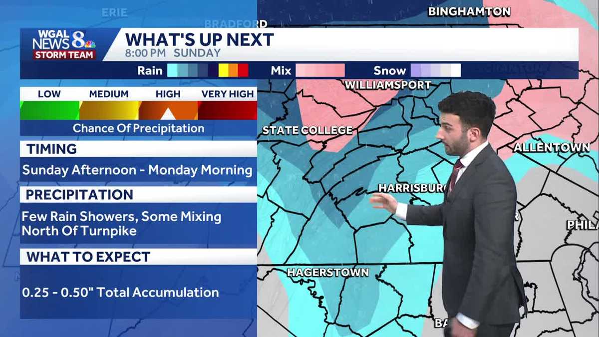
ICY AREAS ARE POSSIBLE ONCE AGAIN TONIGHT. NOW WE WE MELTED OFF SOME OF THE SOME OF THAT LEFTOVER FREEZING RAIN AND SLEET. ALTHOUGH ANY OF THAT LEFTOVER ANY OF THAT, THE LEFTOVER WETNESS OR EVEN THE WET AREAS COULD REFREEZE FOR TONIGHT AS TEMPERATURES ARE DROPPING BELOW FREEZING SUNDAY, RAIN CHANCES WILL BE BACK AROUND FROM THE EARLY AFTERNOON, LASTING UNTIL THE EVENING. TIME COULD SEE SOME MIXING NORTH FOR OUR SUNDAY. THEN THERE’S MORE RAIN ON THE WAY. THAT’S GOING TO BE COMING IN. BETTER CHANCE IS GOING TO BE FOR THE EARLY MORNING HOURS, LET’S SAY BETWEEN 7 A.M. AND 10 A.M. IS WHEN WE’LL SEE THAT. WE’LL SEE A COLD FRONT THAT WILL BRING SOME OF THOSE SHOWER CHANCES, BUT WE WILL SEE SOME INCREASING WINDS LATER IN THE AFTERNOON. SO FOR TONIGHT, MOSTLY CLOUDY, CALM, SEASONABLY CHILLY, 24 TO 28 DEGREES FOR TONIGHT. THEN TOMORROW MORNING LOOKING AT TEMPERATURES GETTING INTO THE 20S ONCE AGAIN. OR THEY’LL SLOWLY RISE OUT OF THE 20S, EVENTUALLY TO THE 30S. BY THE TIME WE MAKE IT TO THE AFTERNOON. AND THEN WE’LL SEE A FEW OF THOSE SHOWERS START TO ROLL IN AFTER THEY START COMING IN LATE IN THE MORNING AROUND 11:00, MAYBE 12 NOON IS WHAT I’M EXPECTING TO SEE. SOME OF THOSE SHOWERS MOVE THROUGH. COULD SEE SOME MIXING NORTH TEMPERATURES GETTING INTO THE UPPER 30S FOR THE AFTERNOON. SO ALMANAC FOR THE DAY TODAY 33 WAS THE HIGH WE REACHED TODAY, BUT 41 THAT’S WHAT WE EXPECT FOR THIS TIME OF YEAR. EARLIER THIS MORNING 29 DEGREES. THAT’S WHAT WE HIT. 26 IS WHAT WE EXPECT FOR OVERNIGHT LOW TEMPERATURES. SO RIGHT AROUND PAR IN TERMS OF OVERNIGHT LOWS. NO RAINFALL RECORDED AT HARRISBURG INTERNATIONAL AIRPORT. SO SUNDAY HERSHEY PARK CHRISTMAS CANDY LANE IF YOU’RE HEADED THERE THAT SAYS SHOULD SAY SUNDAY NOT TODAY. A FEW SHOWERS ARE POSSIBLE WITH SOME MIXING ALSO ON THE TABLE FOR US 33 DEGREES. YOU CAN SEE JUST ABOVE FREEZING, BUT CLOSE ENOUGH TO FREEZING WHERE IT COULD ALLOW FOR THAT MIXING CHANCE. THEN RIGHT AROUND 4:00, STILL LOOKING AT SOME OF THOSE SHOWER CHANCES REMAINING, THEN THOSE SHOWERS WILL TAPER OFF RIGHT AROUND 9:00. THAT’S WHEN WE’LL BE MAINLY CLOUDY AND SIMILAR. FORECAST FOR THE CHRISTMAS SPIRIT LIGHT SHOW AT PENN MEDICINE PARK FROM FIVE 7 TO 9:00. JUST LOOK FOR A FEW OF THOSE SHOWER CHANCES THROUGH THE EVENING. TEMPERATURES INTO THE 30S. NOW 28 IN LANCASTER, 30 IN LEBANON. WE GOT 30 DEGREES IN LEWISTOWN. YOU CAN SEE IN TERMS OF PRECIPITATION, WE’RE QUIET ON STORM TEAM, LIVE RADAR NETWORK JUST REALLY SOCKED IN WITH SOME OF THESE CLOUDS. AS YOU CAN SEE THE SATELLITE IMAGERY THERE. BUT I WANT TO ZOOM OUT AND SHOW YOU IN TERMS OF WHAT THIS STORM SYSTEM IS GOING TO BE LOOKING LIKE AS WE GET INTO, AS WE GET INTO TOMORROW. SO WE’LL STILL BE MAINLY CLOUDY. WE HAVE HIGH PRESSURE SITUATED TOWARDS OUR NORTHEAST, BUT IT’S A IT’S A WEAK AREA OF HIGH PRESSURE. IT’S NOT REALLY DOING A WHOLE LOT OF WORK TO TRY TO CLEAR US OUT, BUT THIS IS WHAT IT LOOKS LIKE IN TERMS OF THE SYSTEM THAT’S GOING TO COME IN RIGHT AROUND 11:00 IN THE MORNING, MAYBE 12 NOON. WE’LL START TO OVERSPREAD THE AREA, BUT YOU CAN SEE A LITTLE BIT OF THAT PINK GETTING MIXED IN WITH SOME OF THOSE SHOWER CHANCES AND ALSO SOME SPECKS OF BLUE. SO THAT’S TELLING ME OR SUGGESTING TO ME THIS DATA IS THAT WE’LL SEE A MIX OF SOME OF THAT RAIN AND POSSIBLY SOME SLEET AS WE GET INTO OUR SUNDAY AFTERNOON, BUT THEN WE’LL SEE THAT LULL IN THE PRECIPITATION. THOSE SHOWERS WILL HAVE ENDED BY 7:00 OR 8:00 IN THE EVENING FOR SUNDAY. BUT HERE COMES HERE COMES MONDAY. THIS COLD FRONT STARTS TO PUSH THROUGH. THAT’S GOING TO GIVE US ANOTHER CHANCE OF SOME SHOWERS BY 9:00 IN THE MORNING. MONDAY MOVES OUT, THEN IT GETS WINDY AND COLDER. FOLKS WILL SEE ANOTHER SURGE OF SOME ARCTIC AIR BEGIN TO MOVE THROUGH. AND THAT’S REALLY WHAT’S WHAT WE’RE GOING TO BE WATCHING NEXT. WE COULD SEE ABOUT A QUARTER TO HALF INCH OF TOTAL ACCUMULATION. BUT IN TERMS OF NEW YEAR’S EVE AND NEW YEAR’S DAY, LOOK AT THIS CHILLY, COLD AND DRY FOR WEDNESDAY NIGHT. COULD SEE A FEW SHOWERS OR SNOW SHOWERS, I SHOULD SAY FOR YOUR THURSDAY. AS YOU CAN SEE REFLECTED IN OUR TEN DAY FORECAST. LOOKING AHEAD INTO NEXT WEEKEND FOR FRIDAY, SATURDAY AND SUNDAY. ST
Rain chances return Sunday & Monday in south-central Pennsylvania
The next system we’re tracking will bring rain to the Valley, along with temperatures into the 50s to start the work week! Looking at another shot of some Artic air to arrive for New Year’s week.

Updated: 11:26 PM EST Dec 27, 2025
Clouds will remain mostly cloudy overnight with temperatures dropping to the mid 20s. Be on the lookout for any refreezing that may occur, especially on poorly/untreated roads this evening through tonight with temperatures falling below freezing.A warm front approaches Sunday bringing a chance for rain in the afternoon and evening. Temperatures climb to the upper 30s.Get ready for a cold blast to end 2025! A strong cold front will pass on Monday afternoon, leading to rain in the morning, then windy conditions in the afternoon and evening. West winds increase 15 to 25 mph, with gusts to 35. Highs will hit near 50 degrees early Monday, then fall to 30 degrees.Winds are even stronger Tuesday with gusts to 40 mph and the direction of winds is northwesterly. Highs only around 30 degrees will feel like the teens to near 20 degrees all day.The last day of 2025 is dry but chilly in the low 30s. Winds are still breezy too. New Year’s Eve is dry with temperatures at midnight around 28 degrees so bundle up if bringing in the new year outside.Another front will take aim at the region on New Year’s Day, bringing a few light snow showers. Temperatures will be cold in the low 30s. Winds are breezy so wind chills will range from the teens to the 20s.The rest of the week into the weekend continues colder than average in the low to mid 30s. A quick moving system may bring a few rain/snow showers early Sunday.Have a great rest of your night!~ Ryan
Clouds will remain mostly cloudy overnight with temperatures dropping to the mid 20s. Be on the lookout for any refreezing that may occur, especially on poorly/untreated roads this evening through tonight with temperatures falling below freezing.
A warm front approaches Sunday bringing a chance for rain in the afternoon and evening. Temperatures climb to the upper 30s.
Get ready for a cold blast to end 2025! A strong cold front will pass on Monday afternoon, leading to rain in the morning, then windy conditions in the afternoon and evening. West winds increase 15 to 25 mph, with gusts to 35. Highs will hit near 50 degrees early Monday, then fall to 30 degrees.
Winds are even stronger Tuesday with gusts to 40 mph and the direction of winds is northwesterly. Highs only around 30 degrees will feel like the teens to near 20 degrees all day.
The last day of 2025 is dry but chilly in the low 30s. Winds are still breezy too. New Year’s Eve is dry with temperatures at midnight around 28 degrees so bundle up if bringing in the new year outside.
Another front will take aim at the region on New Year’s Day, bringing a few light snow showers. Temperatures will be cold in the low 30s. Winds are breezy so wind chills will range from the teens to the 20s.
The rest of the week into the weekend continues colder than average in the low to mid 30s. A quick moving system may bring a few rain/snow showers early Sunday.
Have a great rest of your night!
~ Ryan