
Sunday is the first of two Impact Days with more rain that will end with a brief burst of snow on Monday. Another dose of cold air awaits for the final days of the year and the start of January.Back-to-back Impact Days for rain then plummeting temperaturesSunday is the first of two Impact Days. Rain showers return around mid-morning and will overspread our area. Areas north of Pittsburgh have the best chance for steady rain; spots closer to I-70 will see more breaks in the action. The rain could also be heavy at times, especially north of Pittsburgh. Sunday will also be warm as we reach 60 late in the day. The “warm” air will linger into Monday morning with ongoing showers. A strong cold front will rush through western PA Monday morning. Temperatures will sharply drop through the afternoon.As temperatures fall, rain will transition to a brief burst of snow. Any snow accumulations will be less than half an inch, at best. The I-80 corridor could pick up some light accumulations around inch or two by Tuesday morning.Colder to ring in 2026Wind chills by Monday afternoon will be in the teens. We’ll also be battling 40 to 55 mph gusts. The blustery conditions linger Tuesday. Light snow showers will set up late on New Year’s Eve into New Year’s Day, with the potential for snow to fall during First Night. The cold air with highs near freezing will extend through the early days of January.TONIGHT: Mostly cloudy and chilly. Low: 33°.SUNDAY – Impact Day: Morning rain, heavy at times. Warmer, high: 60°, low: 50°.MONDAY – Impact Day: Rain through late-morning then a burst of snow. Windy with dropping temperatures. Morning high in the mid 50s, in the 20s late but feeling like the single digits.TUESDAY: Breezy with snow showers. High: 28°, low: 22°.
PITTSBURGH —
Sunday is the first of two Impact Days with more rain that will end with a brief burst of snow on Monday. Another dose of cold air awaits for the final days of the year and the start of January.
Back-to-back Impact Days for rain then plummeting temperatures
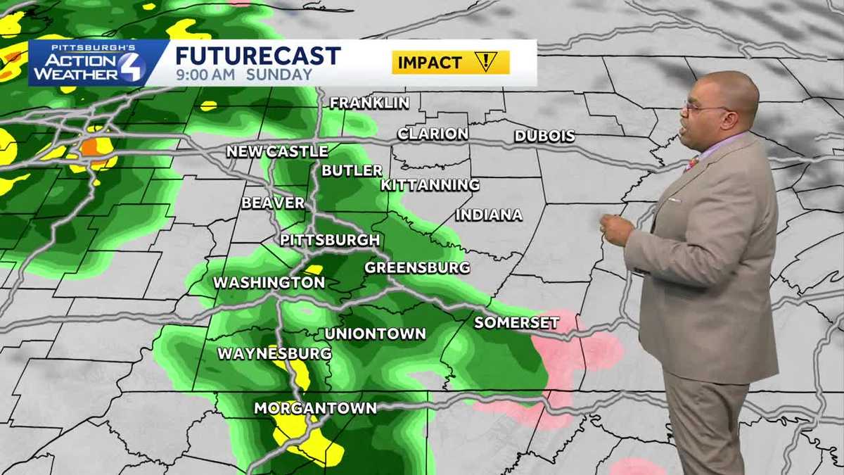
Sunday is the first of two Impact Days. Rain showers return around mid-morning and will overspread our area. Areas north of Pittsburgh have the best chance for steady rain; spots closer to I-70 will see more breaks in the action. The rain could also be heavy at times, especially north of Pittsburgh.

Hearst OwnedHearst
Back-to-back Impact Days for rain, then eventually snow plus dropping temperatures and gusty winds.
Sunday will also be warm as we reach 60 late in the day. The “warm” air will linger into Monday morning with ongoing showers. A strong cold front will rush through western PA Monday morning. Temperatures will sharply drop through the afternoon.

Hearst OwnedHearst
A potent cold front quickly shuts off the rain and drops the temperature Monday morning.
As temperatures fall, rain will transition to a brief burst of snow. Any snow accumulations will be less than half an inch, at best. The I-80 corridor could pick up some light accumulations around inch or two by Tuesday morning.
Colder to ring in 2026
Wind chills by Monday afternoon will be in the teens. We’ll also be battling 40 to 55 mph gusts. The blustery conditions linger Tuesday. Light snow showers will set up late on New Year’s Eve into New Year’s Day, with the potential for snow to fall during First Night. The cold air with highs near freezing will extend through the early days of January.

Hearst Owned
Rain, then rain to snow, and January like temperatures as we welcome in 2026.
TONIGHT: Mostly cloudy and chilly. Low: 33°.
SUNDAY – Impact Day: Morning rain, heavy at times. Warmer, high: 60°, low: 50°.
MONDAY – Impact Day: Rain through late-morning then a burst of snow. Windy with dropping temperatures. Morning high in the mid 50s, in the 20s late but feeling like the single digits.
TUESDAY: Breezy with snow showers. High: 28°, low: 22°.