
Mainly clear this evening into tonight, then a wintry mix developing Friday afternoon in south-central Pennsylvania
Road conditions will deteriorate by Friday evening, and travel will be icy through early Saturday. Looking at another chance for showers for the second half of the weekend.
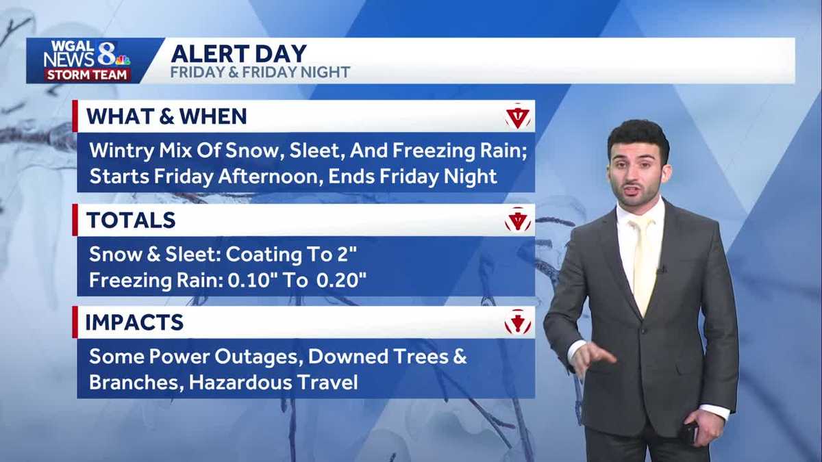
AS WE GET INTO LATE TONIGHT. LOOKING AHEAD INTO FRIDAY, WIDESPREAD WINTRY MIX FRIDAY AFTERNOON THROUGH THE OVERNIGHT PERIOD, THEN AN IMPACT DAY SET FOR SATURDAY FOR SLICK TRAVEL CONDITIONS TO BE DEVELOPING OR REALLY TO REMAIN OR THAT WILL BE REMAINING. WE’LL STILL HAVE NEAR FREEZING TEMPERATURES EVEN AFTER THE STORM HAS MOVED AWAY ON FRIDAY. SO LET’S TALK ABOUT FOR THIS EVENING, MAINLY CLEAR, CHILLIER, A LITTLE BIT BREEZY FOR THIS EVENING, 32 TO 36 DEGREES. AND FOR TONIGHT. STILL LOOKING MOSTLY CLEAR. INCREASING CLOUDS LATE, REMAINING CHILLY INTO THE 20S. BUT WE’RE GOING TO CHAT ABOUT TOMORROW. TOMORROW IS AN ALERT DAY FOR THE AFTERNOON MIX OF OF SLEET AND FREEZING RAIN AND SNOW. IT’S GOING TO LIKE WE WERE SAYING, IT’S GOING TO BE LIKE IT’S GOING TO BE WINTRY AS WE GET INTO TOMORROW, THEN WE’RE GOING TO HAVE MAINLY FREEZING RAIN. BY THE TIME WE GET TO THE EVENING. THAT’S GOING TO BE ALLOWING FOR POSSIBLY A 10TH TO 2/10 OF AN INCH OF SOME OF SOME FREEZING RAIN TO FALL, AND ALLOW A LITTLE BIT OF A LAYER OF ICE TO DEVELOP OVER TOP OF WHAT’S WHAT’S FALLEN EARLIER IN THE AFTERNOON. BUT WE WILL SEE THAT PRECIPITATION TAPER OVERNIGHT, TEMPERATURES REMAINING RIGHT INTO THE 30S RANGE. WINTER WEATHER ADVISORY FOR THE ENTIRE SUSQUEHANNA VALLEY. BUT SOME FOLKS HAVE REACHED OUT. ASKED, WHY DON’T WE GET A WINTER STORM WARNING? BECAUSE WE’RE GETTING ALL THIS. WE’RE GETTING THIS SNOW, SLEET AND FREEZING RAIN. NOW, THE CRITERIA WITH THE NATIONAL WEATHER SERVICE FOR THE MAJORITY OF THE SUSQUEHANNA VALLEY, WE NEED TO HAVE OR WE NEED TO HAVE A CONFIDENCE THAT WE’LL HAVE FIVE INCHES OF SNOW THAT WILL BE FALLING IN THE IN THE SHADED BLUE THAT YOU SEE ON THE MAP HERE. NOW FOR TOWARDS MIFFLIN AND JUNIATA COUNTIES. SIX INCHES. BUT THAT’S WHY WE DID NOT SEE OR ONE OF THE REASONS WHY WE DID NOT SEE A WINTER STORM WARNING, BECAUSE WE’RE NOT GOING TO BE SEEING FIVE INCHES OF SNOW AS WE GET INTO OUR FRIDAY AND FRIDAY NIGHT. AND AGAIN, WE DO HAVE THAT WINTER WEATHER ADVISORY GOING INTO EFFECT AS WE GET INTO TOMORROW. COULD BE SEEING A COATING TO TWO INCHES FREEZING RAIN, ADDING ANOTHER 10TH TO 2/10 OF AN INCH FOR TOMORROW. BUT THE MAIN IMPACTS HERE JUST WATCH OUT FOR POWER OUTAGES AND JUST BE WARY ON THE ROADS, FOLKS. I MEAN, WE’RE GOING TO HAVE A GLAZE OF ICE ON THE ROADS. YOU’RE GOING TO BE SLIPPING AND SLIDING ALL OVER THE PLACE IF YOU TRY AND TRAVEL IN THIS, IT’S DEFINITELY GOING TO BE CREATING HAZARDOUS TRAVEL FOR TOMORROW, FOR THE AFTERNOON, GETTING INTO SATURDAY MORNING. SO ROAD CONDITIONS, CERTAINLY ICY TRANSIT DELAYS, THEY’LL BE HIGH IN TERMS OF THE IMPACTS. POWER OUTAGES ARE MODERATE. VISIBILITY WILL BE REMAINING FAIR. WE JUST HAD RIGHT AROUND 50 DEGREES IN GETTYSBURG, 46 IN CARLISLE, 48 IN YORK AT THIS TIME STILL GOT ABOUT A NORTHERLY BREEZE BETWEEN, I’D SAY BETWEEN 10 AND 15MPH. STORM TEAM, LIVE RADAR NETWORK. ALL IS QUIET RIGHT NOW, BUT THIS IS WHERE THE STORM SYSTEM IS CURRENTLY AT IN THE NORTHERN GREAT PLAINS WILL EVENTUALLY MAKE ITS WAY ACROSS THE MIDWEST TO THE SUSQUEHANNA VALLEY, ALLOWING FOR THAT MIX OF WINTRY PRECIPITATION. SO LET’S TIME IT OUT FOR YOU HERE. SO AS WE GO THROUGH THE REST OF TONIGHT, GETTING INTO TOMORROW, STOPPING THE CLOCK HERE, 1:00 IN THE AFTERNOON, THAT’S WHERE WE’LL START TO SEE THOSE OUTER BANDS THAT MIX OF SOME SLEET AND FREEZING RAIN STARTING TO COME IN, FILTERING IN, EVENTUALLY MAKING ITS WAY TO EASTWARD COUNTIES. BY THE TIME WE GET TO 3:00 IN THE AFTERNOON, BECOMING WIDESPREAD BY FIVE 6:00 IN THE EVENING. CHECK THIS OUT. EVERY COUNTY HERE REALLY SEEING SOME TYPE OF MIXED PRECIPITATION. THE MAJORITY OF THIS IS SLEET AND FREEZING RAIN. AND THAT’S THAT’S WHAT WE NEED TO BE WATCHING OUT FOR NOW. IT WILL TAPER BY THE TIME WE GET TO SATURDAY MORNING, 12 A.M., AND STILL REMAINING MOSTLY CLOUDY AS WE GET INTO THE DAY. NOW, LOOKING AT ABOUT A 10TH OF AN INCH OF SOME SLEET AND SNOW, BUT ALSO LOOKING AT ABOUT A 10TH TO 2/10 OF AN INCH OF FREEZING RAIN. THAT WILL ALLOW A DECENT LAYER OF SOME ICE TO BE DEVELOPING. SO, AND THAT ICE IS GOING TO PERSIST INTO SATURDAY MORNING. SO THAT’S WHY WE HAVE AS AN IMPACT DAY FOR SATURDAY SUNDAY, LOOKING AT SOME SHOWERS LATE. LOOKING AHEAD INTO THE NEW YEAR. GUYS BRISK AND COLD.
Mainly clear this evening into tonight, then a wintry mix developing Friday afternoon in south-central Pennsylvania
Road conditions will deteriorate by Friday evening, and travel will be icy through early Saturday. Looking at another chance for showers for the second half of the weekend.

Updated: 6:49 PM EST Dec 25, 2025
Merry Christmas from the News 8 Storm Team!Partly to mainly clear skies are on tap this evening, with temperatures dropping to the low to mid 30s. Winds will remain light out of the north.Tonight, mostly clear skies are in store, with lows in the mid-20s. Clouds will increase toward sunrise Friday.ALERT FRIDAY: WIDESPREAD WINTRY MIXA Winter Storm Watch is in effect for the Susquehanna Valley Friday through Friday night. Snow and sleet accumulations of a coating to 2″, and 0.10″ to 0.20″ of freezing rain is expected.Low pressure will pass to our south on Friday, while high pressure presses in from the northeast. This will lead to a wintry mix developing by early afternoon. Arrival time is 1 to 5 p.m. from west to east.Initially, precipitation will fall as light snow in most areas, then as warmer air moves into the lower levels of the atmosphere, sleet and freezing rain will develop. Most areas will have an icy mix by evening, and sleet and freezing rain will continue until about 3 a.m. Saturday. Precipitation will be gone by sunrise Saturday.Highs will hover near freezing on Friday, then fall to the upper 20s Friday night. Travel conditions will deteriorate by late Friday afternoon, so getting to your destination early Friday afternoon is the best bet!IMPACT SATURDAY:Saturday will be dry and chilly under mostly cloudy skies. Highs will reach the low 30s. Please be mindful that icy conditions will last through Saturday morning, because temperatures will be slow to warm. Untreated surfaces will likely remain icy through late morning.A chance of rain returns late Sunday, as highs climb to the upper 30s.Get ready for a cold blast to end 2025! A strong cold front will pass Monday afternoon, leading to rain in the morning, then windy conditions in the afternoon and evening. Highs will hit the low 40s early Monday, then fall to 30 degrees Tuesday, and the low-30s Wednesday.Another front will take aim at the region on New Year’s Day, keeping highs in the low-to-mid 30s through the end of the week. Wind chills will range from the teens to 20s most days.Have a great rest of your evening!~ Ryan
Merry Christmas from the News 8 Storm Team!
Partly to mainly clear skies are on tap this evening, with temperatures dropping to the low to mid 30s. Winds will remain light out of the north.
Tonight, mostly clear skies are in store, with lows in the mid-20s. Clouds will increase toward sunrise Friday.
ALERT FRIDAY: WIDESPREAD WINTRY MIX
A Winter Storm Watch is in effect for the Susquehanna Valley Friday through Friday night. Snow and sleet accumulations of a coating to 2″, and 0.10″ to 0.20″ of freezing rain is expected.
Low pressure will pass to our south on Friday, while high pressure presses in from the northeast. This will lead to a wintry mix developing by early afternoon. Arrival time is 1 to 5 p.m. from west to east.
Initially, precipitation will fall as light snow in most areas, then as warmer air moves into the lower levels of the atmosphere, sleet and freezing rain will develop. Most areas will have an icy mix by evening, and sleet and freezing rain will continue until about 3 a.m. Saturday. Precipitation will be gone by sunrise Saturday.
Highs will hover near freezing on Friday, then fall to the upper 20s Friday night. Travel conditions will deteriorate by late Friday afternoon, so getting to your destination early Friday afternoon is the best bet!
IMPACT SATURDAY:
Saturday will be dry and chilly under mostly cloudy skies. Highs will reach the low 30s. Please be mindful that icy conditions will last through Saturday morning, because temperatures will be slow to warm. Untreated surfaces will likely remain icy through late morning.
A chance of rain returns late Sunday, as highs climb to the upper 30s.
Get ready for a cold blast to end 2025! A strong cold front will pass Monday afternoon, leading to rain in the morning, then windy conditions in the afternoon and evening. Highs will hit the low 40s early Monday, then fall to 30 degrees Tuesday, and the low-30s Wednesday.
Another front will take aim at the region on New Year’s Day, keeping highs in the low-to-mid 30s through the end of the week. Wind chills will range from the teens to 20s most days.
Have a great rest of your evening!
~ Ryan