
A cold front arrives tonight to bring rain showers and usher in windy conditions and colder air to end the year. We return to the deep freeze to start 2026.Wind and Winter AlertsA Wind Advisory is up for all of Western PA along with Monongalia and Preston Counties. A High Wind Warning is up for Garrett County. Both alerts go from 1 a.m. Monday to 1 a.m. Tuesday. Wind gusts could reach 50 mph. For Garrett County, wind gusts could reach 65 mph.A Winter Weather Advisory is up for Clarion, Forest, Venango, Preston, Garrett, and the higher elevations of Indiana, Westmoreland, Fayette, and Monongalia counties. Snow from Monday morning through Tuesday morning could reach as much as five inches in sustained lake effect snow bands.Impact Days: Rain to snow, strong winds, single digit wind chillsA strong cold front will rush through Western PA Monday morning. Temperatures will sharply drop through the afternoon. As temperatures fall, rain will transition to a brief burst of snow. Wind chills by Monday afternoon will be in the teens. We’ll also be battling 40 to 55 mph gusts. Snow showers will end Tuesday afternoon as the wind stops crossing the Great Lakes. Any snow accumulations will an inch or less for locations outside of the winter weather advisory.Cold and snowy pattern into 2026More light snow showers will set up late on New Year’s Eve into New Year’s Day, with the potential for snow to fall during First Night. The cold air with highs near freezing will extend through the early days of January.MONDAY – Impact Day: Rain through sunrise then a burst of snow. Windy with dropping temperatures. Morning high near 54°, in the 20s late but feeling like the single digits in the afternoon.TUESDAY – Impact Day: Breezy with snow showers in the morning. High: 28°, low: 22°.NEW YEAR’S EVE: Cloudy and cold with snow late. High: 31°, low: 15°.
PITTSBURGH —
A cold front arrives tonight to bring rain showers and usher in windy conditions and colder air to end the year. We return to the deep freeze to start 2026.
Wind and Winter Alerts
A Wind Advisory is up for all of Western PA along with Monongalia and Preston Counties. A High Wind Warning is up for Garrett County. Both alerts go from 1 a.m. Monday to 1 a.m. Tuesday. Wind gusts could reach 50 mph. For Garrett County, wind gusts could reach 65 mph.

Hearst Owned
Wind Advisory and High Wind Warnings for Western PA, West Virginia, and Maryland.
A Winter Weather Advisory is up for Clarion, Forest, Venango, Preston, Garrett, and the higher elevations of Indiana, Westmoreland, Fayette, and Monongalia counties. Snow from Monday morning through Tuesday morning could reach as much as five inches in sustained lake effect snow bands.

Hearst Owned
Winter Weather Advisory for the I-80 corridor and Laurel Highlands as lake effect snow bands could produce up to 5 inches in spots.
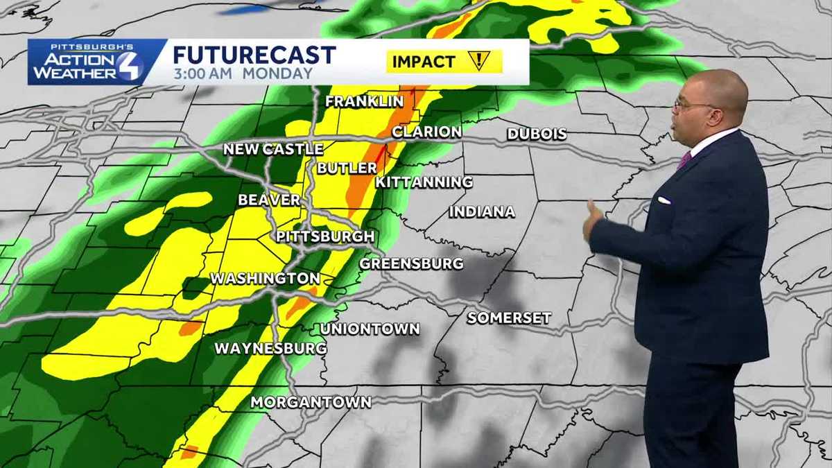
Impact Days: Rain to snow, strong winds, single digit wind chills
A strong cold front will rush through Western PA Monday morning. Temperatures will sharply drop through the afternoon. As temperatures fall, rain will transition to a brief burst of snow. Wind chills by Monday afternoon will be in the teens. We’ll also be battling 40 to 55 mph gusts.
Snow showers will end Tuesday afternoon as the wind stops crossing the Great Lakes. Any snow accumulations will an inch or less for locations outside of the winter weather advisory.

Hearst Owned
Snow totals by the end of snow Tuesday afternoon will generally be around one inch, except for the I-80 corridor and Laurel Highlands.
Cold and snowy pattern into 2026
More light snow showers will set up late on New Year’s Eve into New Year’s Day, with the potential for snow to fall during First Night. The cold air with highs near freezing will extend through the early days of January.

Hearst Owned
It will feel like January as we welcome in the new month and year.
MONDAY – Impact Day: Rain through sunrise then a burst of snow. Windy with dropping temperatures. Morning high near 54°, in the 20s late but feeling like the single digits in the afternoon.
TUESDAY – Impact Day: Breezy with snow showers in the morning. High: 28°, low: 22°.
NEW YEAR’S EVE: Cloudy and cold with snow late. High: 31°, low: 15°.