
SHORT TERM FORECAST
TONIGHT: Clear to partly cloudy with brisk evening breezes diminishing overnight. Low: 19
FRIDAY: Cloudy and cold with snow and sleet developing later in the day. High: 29
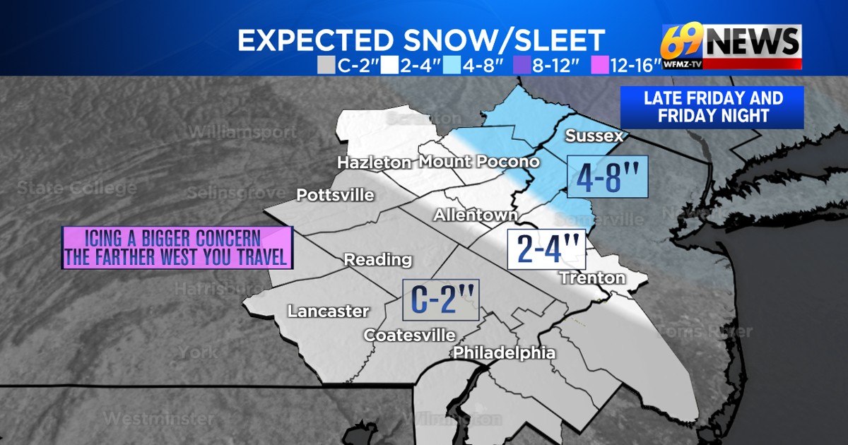
FRIDAY NIGHT: Cloudy with a mix of snow, sleet, and freezing rain and drizzle gradually tapering off towards morning. Total snow/sleet accumulations: 2-4″ Lehigh Valley, C-2″ south and west of Lehigh Valley, 4-8″ eastern Poconos and Warren/Sussex counties in NJ Low: 24
FORECAST SUMMARY
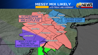
While it was a bit windy on Christmas afternoon, it was an otherwise quiet day weather-wise. And it’s those winds that have started to process to bring in some cold air ahead of a round of wintry weather later Friday into Friday night. While the air is plenty cold enough to make this all wintry and not wet, it won’t be all snow for most of us either. Instead, it’s a wintry mix of first snow and then sleet and freezing rain and drizzle that will make for slick travel and light accumulations of snow, sleet, and ice for much of the area. Where it’s mostly snow, across Monroe, Pike, Sussex, and Warren counties, it can be as much as 4-8″ of snow and a little sleet for a storm total. For the Lehigh Valley, western Poconos, and into Bucks and Hunterdon counties, it’s probably 2-4″ of snow/sleet, with a decent amount being sleet, those ice pellets that sting but don’t accumulate as readily as snow. Farther south and west from there, it’s a coating to an inch or two of snow, sleet, and a glaze of ice from freezing rain too. All of this develops Friday mid to late afternoon, peaks in the evening, and then continues but becomes a little lighter and more scattered the later into the night you go. Beyond this wintry mess, Saturday is cold and cloudy but drier overall, and Sunday is also cloudy, a little less cold, and eventually wet with some plain rain arriving later in the day and continuing into early Monday. Arctic cold and gusty winds will follow that rain to round out the forecast for 2025 through the middle of next week.

DETAILED FORECAST
TONIGHT
Skies will start out mostly clear tonight, and likely finish the night partly cloudy. While some brisk breezes from the daytime will spill over into the evening hours, winds will gradually diminish overnight to around 10mph or less. It will be a cold and dry Christmas night, with lows around the 20 degree mark.
FRIDAY AND FRIDAY NIGHT
Clouds will thicken on a cold Friday, with highs only expected to reach the upper 20s. While the day starts dry, and it stays dry through early to mid-afternoon, snow, or a mix of snow and sleet, should develop from west to east across the area by late afternoon. Snow will be steadiest north and east of the Lehigh Valley, with limited mixing with sleet across areas of northwestern NJ and northeastern PA, where the heaviest snow accumulations are expected (4-8″ for parts of Monroe, Pike, Sussex, and Warren counties). For the Lehigh Valley, along with the western Poconos and into Bucks and Hunterdon counties, snow is expected, but a heavier dose of sleet is expected here too, and even a light glaze of ice from freezing rain. So accumulations will be less, but 2-4″ of snow/sleet is still possible. Then farther south and west from here, it’s mostly sleet and freezing rain, and only minimal snow. So it’s a coating to an inch of snow and sleet, but perhaps more ice that can slicken things up just the same. The wintry mix should lighten and become more scattered in nature later Friday night, with the biggest travel impacts expected Friday evening.
SATURDAY
Some flurries or some freezing drizzle may linger early Saturday morning, but the accumulations will likely be done. Clouds linger the rest of a cold and gray Saturday, but it should be a mostly dry day otherwise. Highs will remain in the low 30s, with some residual slick travel likely, especially early in the day. There can be a little clearing Saturday night, with partly cloudy skies and overnight lows into the upper teens.
SUNDAY AND MONDAY
The cold will briefly ease ahead of our next cold front and weather maker, which this time will make just rain, plain rain, for the entire area, starting later Sunday, continuing through Sunday night, and lasting through the first half of Monday. It’s generally a ½ inch or less of plain rain expected, with brisk winds sending temps briefly into the 40s later Sunday night into Monday ahead of our front. Behind that front, winds ramp up even more, shift from the northwest, and send in some arctic air starting Monday night. Both Sunday and Monday continue the streak of mainly cloudy days, with Sunday starting dry and Monday ending that way.
TUESDAY THROUGH THURSDAY
It looks like the old year (2025) will end and the new year (2026) will begin fairly similarly next week, with cold, brisk, and mostly dry weather for the middle and end of next week. Expect partly sunny skies and cold highs in the upper 20s to low 30s, with Tuesday likely being the coldest and windiest day, with the winds easing up if only slightly towards the start of the new year. Overnight lows will mostly be in the upper teens to low 20s.
TRACK THE WEATHER:
LINKS: HOUR BY HOUR | RADAR | TRAFFIC