
INVESTIGATION INTO THE CAUSE OF THE DERAILMENT. GOOD AFTERNOON. WE ARE STILL TRACKING THE STRONG WINDS IN THIS WIND ADVISORY ACROSS THE SUSQUEHANNA VALLEY. AS WE GO THROUGH THE REST OF THE DAY TODAY, AND FOR GOOD REASON. HERE’S A LOOK AT THE WIND GUSTS SO FAR OR CURRENTLY ACROSS THE AREA. 51MPH IN CHAMBERSBURG, LEWISTOWN, MIFFLIN COUNTY. THERE AROUND 40MPH. I AM STARTING TO SEE SOME SPOTTY POWER OUTAGES POPPING UP IN PARTS OF CENTRAL PENNSYLVANIA, AS THE STRONG WINDS ARE MOVING THROUGH. SO AGAIN, WE ARE WATCHING FOR POWER OUTAGES AS WE GO THROUGH THE AFTERNOON AND EVENING. AND UNFORTUNATELY, STARTING TO SEE THAT ALREADY COME TO FRUITION IN SOME CASES. HERE’S A LOOK AT THE WIND GUSTS FOR THE NEXT 12 HOURS. YOU CAN SEE THAT WE WILL STILL KEEP THAT WIND ELEVATED ABOVE 40MPH FOR MOST OF THE DAY TODAY, EVEN CLOSE TO 50MPH FOR THE NEXT FEW HOURS. SO MAKE SURE EVERYTHING OUTSIDE IS SECURE, WON’T GET BLOWN AROUND AS THOSE WINDS ARE NOW STARTING TO APPROACH. EVEN OUR EASTERN COUNTIES, LEBANON AND LANCASTER. YOU’RE STARTING TO SEE THOSE WINDS INCREASE FOR YOU AS WELL. THE IMPACT DAY WILL LAST UNTIL NOON TOMORROW. THAT’S ALSO WHEN THE WIND ADVISORY WILL EXPIRE FROM THE NATIONAL WEATHER SERVICE STORM TEAM LIVE RADAR NETWORK SHOWING WE ARE DRYING OUT THOUGH THE RAIN THAT CAME THROUGH EARLIER THIS MORNING LAST NIGHT, THAT’S NOW OFF TO THE EAST AND NOW IT’S ALL THE WIND HERE ACROSS THE AREA, INCLUDING IN LANCASTER. WE HAVE THE SKY CLEARING OUT A LITTLE BIT OF SUNSHINE HERE, BUT IT IS VERY WINDY. THE SUSTAINED WINDS ARE IN THE 20S ACROSS THE AREA. GUSTS ARE GOING TO BE 1015 MILES OVER THAT AT LEAST AS WE GO THROUGH THE AFTERNOON HERE. SO 44 DEGREES, THE CURRENT TEMPERATURE THERE. HERE’S A LOOK AT WHAT YOU CAN EXPECT THE NEXT FEW HOURS. WE WILL SEE THOSE TEMPERATURES START TO DROP THROUGHOUT THE AFTERNOON AND EVENING HERE. BEHIND THAT FRONT IT’S USHERING COLDER AIR. SO IT ONLY MAKES SENSE THAT TEMPERATURES WILL DROP AS WE GO THROUGH TONIGHT. UPPER 20S EXPECTED MOSTLY CLOUDY WITH THOSE STRONG WINDS CONTINUING TONIGHT AND EVEN TOMORROW. IT’S STILL WINDY. VERY WINDY IN THE MORNING, IN FACT. AND THEN THE WINDS DIE DOWN AS WE GO THROUGHOUT YOUR TUESDAY AFTERNOON AND EVENING. BY TOMORROW NIGHT IT’S MUCH CALMER. SO HERE’S A LOOK AT PREDICTOR THAT FRONT ALREADY OFF TO THE EAST. IT’S WINDY AND COLDER. BUT WE DO STAY DRY THROUGH THE REST OF THE DAY TODAY. TONIGHT MAYBE A FEW FLURRIES UP IN MIFFLIN AND JUNIATA COUNTY. NOT OUT OF THE QUESTION, BUT AT THE MOMENT IT DOES APPEAR THAT YOU ARE GOING TO STAY DRY FOR YOUR TUESDAY. WINDY START, BUT CALMER, AND WE SEE THE WINDS CALM DOWN THROUGH TOMORROW AFTERNOON, AND BY TOMORROW NIGHT THINGS ARE A LOT BETTER AS WE GO INTO THE FINAL DAY OF 2025. MOSTLY CLOUDY FOR THE AREA HERE AND BELIEVE IT OR NOT, WE ARE WATCHING ANOTHER SYSTEM THAT COME THROUGH HERE COULD BRING US A FEW SNOW SHOWERS ACTUALLY, AS WE WELCOME IN 2025. SO THIS MODEL SHOWING A FEW SCATTERED SNOW SHOWERS HERE RIGHT AROUND MIDNIGHT AND THE SUSQUEHANNA VALLEY. SO SOME OF YOU MAY BE SEEING SOME SNOWFLAKES AS YOU WELCOME IN THE NEW YEAR HERE. WEDNESDAY NIGHT INTO THURSDAY MORNING. AND WHEN WE LOOK AT THE FORECAST KIND OF SHOWS THAT TEMPERATURES ARE DEFINITELY GOING TO BE COLD ENOUGH WEDNESDAY NIGHT, A LOW OF 22. SO IF YOU ARE HEADING OUT TO THE MANY EVENTS AROUND THE SUSQUEHANNA VALLEY, MAKE SURE YOU BUNDLE UP HERE, BECAUSE IT’S DEFINITELY GOING TO FEEL LIKE WE’RE IN THE MIDDLE OF WINTER WITH A FEW MORNING SHOWERS. SNOW SHOWERS THERE ON THURSDAY. THE REST OF YOUR TEN DAY FORECAST SHOWING FRIDAY AND SATURDAY. CHILLY BUT QUIET AND SEASONABLY CHILLY THERE ON SUNDAY. AND THEN JACOB. IT TURNS A LITTLE MORE ACTIVE AS WE HEAD INTO THE END OF THE TEN
IMPACT: Strong Winds Across South Central Pennsylvania Though Tuesday
Winds will increase 45 to 55 mph and temperatures will sharply drop during the afternoon.

Updated: 1:26 PM EST Dec 29, 2025
Good afternoon,A Wind Advisory goes into effect for the entire Susquehanna Valley from 7 am this morning through 12 pm Tuesday.IMPACT DAYS MONDAY & TUESDAYWest winds increase 15 to 25 mph, with possible gusts 45 to 55 mph! It’s going to be a blustery rest of our Monday, so be prepared. Impacts: Scattered tree branches, downed trees, some power outages, and any items not secured around your home may be blown away. If you drive a high-profile vehicle, keep a firm grip with both hands on the steering wheel.On Tuesday, the winds remain strong, with gusts still over 40 mph. Temperatures top out in the low 30s, but will feel like the teens, to near 20 degrees, all day.The last day of 2025 is dry but chilly in the low 30s. If you are ringing in the new year outside, temperatures at midnight will be around 28 degrees,s so bundle up!Another front will aim for the region Wednesday overnight into early New Year’s Day, bringing a few light snow showers for the morning. Temperatures will be cold in the upper 20s to around 30 degrees. Winds are breezy, so wind chills will range from the teens to the 20s.The rest of the week into the weekend continues colder than average in the low to mid 30s. A quick-moving system may bring a few rain/snow showers early Sunday. There is a better chance for rain and/or snow showers on Tuesday.Have a great day!
Good afternoon,
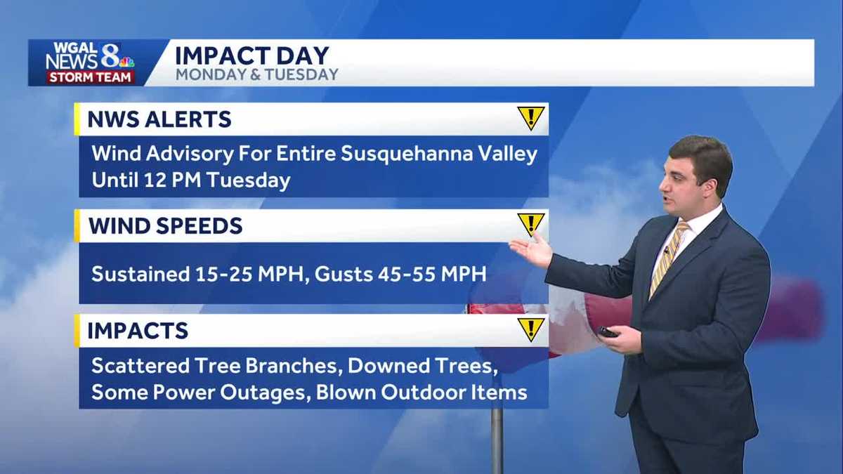
A Wind Advisory goes into effect for the entire Susquehanna Valley from 7 am this morning through 12 pm Tuesday.
IMPACT DAYS MONDAY & TUESDAY
West winds increase 15 to 25 mph, with possible gusts 45 to 55 mph! It’s going to be a blustery rest of our Monday, so be prepared. Impacts: Scattered tree branches, downed trees, some power outages, and any items not secured around your home may be blown away. If you drive a high-profile vehicle, keep a firm grip with both hands on the steering wheel.
On Tuesday, the winds remain strong, with gusts still over 40 mph. Temperatures top out in the low 30s, but will feel like the teens, to near 20 degrees, all day.
The last day of 2025 is dry but chilly in the low 30s. If you are ringing in the new year outside, temperatures at midnight will be around 28 degrees,s so bundle up!
Another front will aim for the region Wednesday overnight into early New Year’s Day, bringing a few light snow showers for the morning. Temperatures will be cold in the upper 20s to around 30 degrees. Winds are breezy, so wind chills will range from the teens to the 20s.
The rest of the week into the weekend continues colder than average in the low to mid 30s. A quick-moving system may bring a few rain/snow showers early Sunday. There is a better chance for rain and/or snow showers on Tuesday.
Have a great day!