
Warmer & breezy tomorrow, then rain & storm chances return late Sunday for south-central Pennsylvania
We end the day on a mainly clear and mild note. Sunday starts off dry, but rain and storm chances increase after sunset. We have the latest timing and forecast.
EVEN FEEL LIKE WINTER OR EVEN FALL OUTSIDE TODAY. RYAN I MEAN, IT WAS JUST A PERFECT WARM, SUNNY OCTOBER DAY. YEAH, AND TEMPERATURES ARE STILL IN THE IN THE 70S IN SOME AREAS. SOME AREAS ARE STARTING TO HIT THE 60S, BUT OTHER AREAS ARE QUITE A MILD DAY. AND THAT’S REALLY GOING TO BE THE STORY FOR THE REST OF THIS EVENING. AS WE GET INTO AS WE GET INTO THE OVERNIGHT PERIOD. NOW, I WILL SAY IT’S GOING TO BE A BREEZY DAY SUNDAY, BUT NOTICE THE IMPACT ICON HERE. THIS IS NOT FOR DURING THE DAY SUNDAY. IT’S GOING TO BE WARM, BREEZY, PARTLY SUNNY. IT’S GOING TO BE A NICE DAY FOR THE BEGINNING PART OF THE DAY. IT’S WHEN WE GET INTO LATE IN THE DAY, WE ARE LOOKING AT THE CHANCE FOR SOME RAIN AND STORMS TO BE COMING IN, ESPECIALLY LIKE ONCE WE GET INTO LATER ON SUNDAY. SO WE’LL CHAT ABOUT THAT HERE IN A SECOND. BUT WE DO HAVE AN IMPACT NIGHT IN PLACE NOW FOR OUR SUNDAY NIGHT. BUT THEN ONCE WE GET INTO MONDAY MORNING, STILL SEEING SOME LINGERING SHOWERS, BUT IT WILL BE BREEZY. HIGHS ARE BACK TO THE 60S, BUT THE REST OF THE DAY FOR MONDAY LOOKING LIKE IT’S GOING TO BE DRY. SO FOR THE REST OF THIS EVENING, TEMPERATURES GETTING INTO THE UPPER 50S AND LOWER 60S LATER IN THE EVENING, MOSTLY CLEAR AND MILD WITH A SOUTHEASTERLY WIND BETWEEN 5 AND 10MPH. WE’RE PARTLY CLOUDY AND MILD GETTING INTO TONIGHT INTO THE 50S, AND THEN ONCE WE GET INTO TOMORROW, THERE’S THE IMPACT ICON AGAIN. AGAIN, THE DAY IS FINE. DURING THE DAY IT’S GOING TO BE WARM. IT’LL BE BREEZY, PARTLY SUNNY. IT’S MY CONCERN IS WHEN WE GET INTO LATER IN THE EVENING WHEN WE GET INTO CLOSER TO 7:00 OR 8:00 AFTER SUNSET IS WHEN WE HAVE THAT CHANCE FOR RAIN AND STORMS TO COME IN, AND IT WILL BE BREEZY AND ALSO WARM INTO THE 70S COULD POTENTIALLY GUST TO 30MPH. FOLKS, DURING THE AFTERNOON. SO LET’S CHAT ABOUT TOMORROW. TIMING FOR THESE STORMS 7 P.M. TO 2 A.M. WHAT WE’RE WATCHING IS THIS LINE OF STORMS ARE GOING TO BE COMING IN AND COULD BE PACKING A PUNCH WITH DAMAGING WIND GUSTS, AND ALSO SOME BRIEF HEAVY RAIN. THE TIME FRAME ONCE AGAIN 7 P.M. TO 2 A.M. SO THE DAY FOR YOUR SUNDAY IS GOING TO BE FINE. BUT WE DO HAVE A LEVEL ONE OUT OF FIVE SEVERE RISK FOR LATER ON SUNDAY. BUT THEN ONCE WE GET INTO MONDAY, WE’LL START WITH SOME MORNING SHOWERS, THEN TURNING PARTLY SUNNY, BREEZY AND COOLER INTO THE 60S. WINDS OUT OF THE WEST NORTHWEST BETWEEN 10 AND 20MPH FOR YOU. SATURDAY. TODAY, 73 DEGREES. THAT’S WHAT WE HIT AT HARRISBURG INTERNATIONAL AIRPORT. WE DO EXPECT 65 DEGREES FOR THIS TIME OF THE YEAR. SO THIS IS WHY WE’RE SAYING THIS EVENING IT’S BEEN MILD AND IT’S GOING TO BE MILD ONCE AGAIN FOR TOMORROW. WEATHER IN HEALTH FOR THE DAY TOMORROW. POLLEN LEVELS WILL BE LOW. MOLD LEVELS ARE LOW, UV INDEX IS LOW. BUT WE DO HAVE A MODERATE AIR QUALITY AS WE GET INTO THE DAY TOMORROW, SUNDAY AND MONDAY ARE OUR NEXT BEST CHANCES OF RAIN, ESPECIALLY LATE SUNDAY. GETTING INTO THE OVERNIGHT PERIOD HERE’S. WE’RE STILL IN THE 70S NOW TOWARDS WESTERN COMMUNITIES LEWISTOWN, CARLISLE, GETTYSBURG, CHAMBERSBURG DOWN INTO THE 60S FOR OTHER AREAS MORE TOWARDS THE EAST. HERE ARE THE HERE ARE THE DEW POINTS RIGHT NOW. VERY DRY OUT THERE HELPING TO PROMOTE THE THE PLEASANT FEELING AIR. YOU CAN SEE WINDS ARE NOT SO BAD RIGHT NOW. IT’S A LIGHT BREEZE OUT OF THE SOUTH. BUT LOOK WHERE WE HEAD TO ONCE WE GET INTO SUNDAY AFTERNOON. LOOK AT THESE GUSTS. 29 MILE PER HOUR BREEZE IN HARRISBURG, 33 MILE PER HOUR GUSTS IN CARLISLE, 31 MILE PER HOUR GUSTS IN LANCASTER. IT’S GOING TO BE A WINDY AFTERNOON FOR TOMORROW. THAT’S THAT’S SEPARATE FROM THE STORMS ARE GOING TO BE COMING IN AS WE GET INTO OUR SUNDAY. SO LET ME TIME THINGS OUT FOR YOU. STORM TEAM LIVE AT OUR NETWORK. ALL IS QUIET RIGHT NOW THANKS TO HIGH PRESSURE CENTERED CENTERED IN OVER THE EASTERN SEABOARD. BUT HERE COMES THAT NEXT COLD FRONT THAT’S GOING TO START TO COME THROUGH. HERE’S THE TIMING STARTS TO COME INTO OUR WESTERN FRINGES OR THE WESTERN COUNTIES. ONCE WE GET INTO 7:00 IN THE EVENING, PROCEEDING THROUGH THE REST OF THE AFTERNOON INTO THE OR, EXCUSE ME, THE REST OF THE EVENING INTO THE OVERNIGHT PERIOD, THAT’S WHEN WE’LL START TO SEE MORE OF THE SEVERE, THE SEVERE POTENTIAL START TO PUSH EASTWARD TOWARDS LANCASTER COUNTY, LEBANON COUNTIES. AND HERE’S THAT CHANCE FOR SOME LINGERING MORNING SHOWERS AS WE GET INTO OUR MONDAY. THEN THE REST OF THE DAY FOR MONDAY. LOOKING DRY, MOSTLY SUNNY, SO WE’LL BE OKAY AS WE GET INTO MONDAY AFTERNOON. THE REST OF THE FORECAST LOOKING SEASONABLE MONDAY THROUGH FRIDAY OF NEXT WEEK COULD BE HITTING THE UPPER 50S FOR OUR THURSDAY, BUT CHECK THIS OUT. PART
Warmer & breezy tomorrow, then rain & storm chances return late Sunday for south-central Pennsylvania
We end the day on a mainly clear and mild note. Sunday starts off dry, but rain and storm chances increase after sunset. We have the latest timing and forecast.

Updated: 7:08 PM EDT Oct 18, 2025
It has remained mostly clear with temperatures lowering through the low 60s this evening. Mild evening for any outdoor activities!Tonight, sky cover will be on the increase, so we’ll have partly cloudy skies overnight. Lows are milder in the low to mid 50s.Another warm & breezy day is on tap for Sunday afternoon with partly sunny conditions. Southerly winds will be in the 10 to 20 mph range, with gusts pushing the 30 mph mark, which will assist in pushing highs back to the mid-70s. Rain chances hold off until after sunset.The Storm Prediction Center has highlighted the Susquehanna Valley in a Marginal Risk (a level 1 out of 5) for severe weather with damaging winds & heavy rain as the primary threats. As a slow-moving cold front approaches the area Sunday night, a line of showers and storms with gusty winds are expected to impact the Valley. Main timing is between 7 PM and 2 AM. Winds may gust to 30-40 mph with the passage of the front. With these storm threats in mind, the News 8 Storm Team has declared an Impact period for Sunday night from 7 PM – 2 AM. Also, if you have outdoor holiday decorations, such as inflatables or other items that may be unfastened, you may want to consider bringing decor items inside temporarily for Sunday night.Once the cold front pushes through, rain chances stick around from overnight Sunday into Monday morning as the upper-level system continues swinging through the Commonwealth. So for your Monday morning commute, expect some lingering showers up until around noon or 1 PM Monday afternoon. Skies become sunnier by Monday afternoon and will be cooler & breezy, thanks to west-northwest winds 10 to 20 mph. Winds may gust to 30 mph again for Monday. Highs will fall back to more seasonable norms in the low to mid 60s.Temperatures are in the mid 60s again on Tuesday, then another front is expected to knock temperatures down a bit into the upper 50s to low 60s the rest of the week.Have a great rest of your Saturday!~ Ryan
It has remained mostly clear with temperatures lowering through the low 60s this evening. Mild evening for any outdoor activities!
Tonight, sky cover will be on the increase, so we’ll have partly cloudy skies overnight. Lows are milder in the low to mid 50s.
Another warm & breezy day is on tap for Sunday afternoon with partly sunny conditions. Southerly winds will be in the 10 to 20 mph range, with gusts pushing the 30 mph mark, which will assist in pushing highs back to the mid-70s. Rain chances hold off until after sunset.
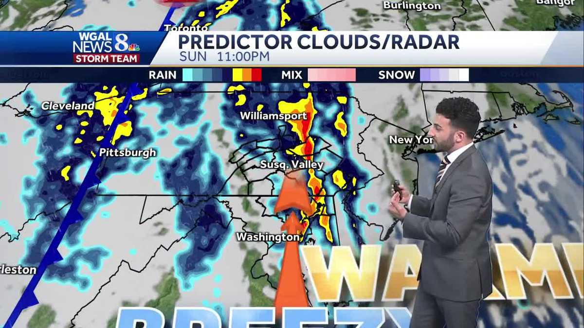
The Storm Prediction Center has highlighted the Susquehanna Valley in a Marginal Risk (a level 1 out of 5) for severe weather with damaging winds & heavy rain as the primary threats. As a slow-moving cold front approaches the area Sunday night, a line of showers and storms with gusty winds are expected to impact the Valley. Main timing is between 7 PM and 2 AM. Winds may gust to 30-40 mph with the passage of the front. With these storm threats in mind, the News 8 Storm Team has declared an Impact period for Sunday night from 7 PM – 2 AM. Also, if you have outdoor holiday decorations, such as inflatables or other items that may be unfastened, you may want to consider bringing decor items inside temporarily for Sunday night.
Once the cold front pushes through, rain chances stick around from overnight Sunday into Monday morning as the upper-level system continues swinging through the Commonwealth. So for your Monday morning commute, expect some lingering showers up until around noon or 1 PM Monday afternoon. Skies become sunnier by Monday afternoon and will be cooler & breezy, thanks to west-northwest winds 10 to 20 mph. Winds may gust to 30 mph again for Monday. Highs will fall back to more seasonable norms in the low to mid 60s.
Temperatures are in the mid 60s again on Tuesday, then another front is expected to knock temperatures down a bit into the upper 50s to low 60s the rest of the week.
Have a great rest of your Saturday!
~ Ryan