
Increasing clouds later this evening; still brisk into tonight across south-central Pennsylvania
Feels like temperatures will be in the teens today as we kick off the new year! A calmer weekend is in store, then an unsettled pattern to come for next week.
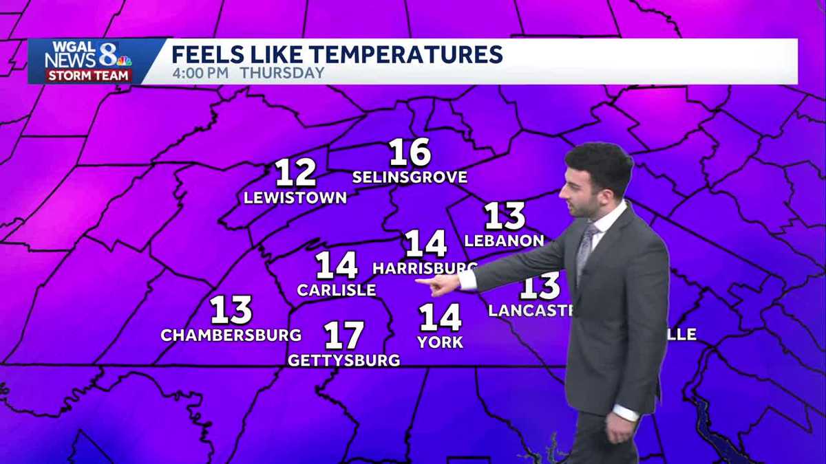
GOT SOME MOSTLY SUNNY SKIES ACROSS THE AREA, ALTHOUGH I WILL SAY MAN, IS IT COLD OUT THERE. WE HAD A STRONG COLD FRONT THAT CAME THROUGH THE SUSQUEHANNA VALLEY EARLIER THIS MORNING. OR YOU COULD SAY OVERNIGHT LAST NIGHT BETWEEN LIKE 12 AND 4 A.M. BUT MAN, THOSE WINDS, THEY WERE THEY WERE HAULING LAST NIGHT. I’M NOT SURE ABOUT YOU, BUT LANCASTER RIGHT NOW WINDS IS STILL A LITTLE BIT ELEVATED OUT OF THE NORTHWEST. YOU CAN SEE RIGHT AROUND 25 DEGREES. FACTOR THAT IN WITH THE WINDS. LOOK AT THE FEELS LIKE TEMPERATURES. FEELS LIKE 13 DEGREES IN LANCASTER AT THE AT THAT TIME. SO BRISK START TO 2026 SO FAR THOUGH ONCE WE GET INTO THE WEEKEND IT’S CALMER. STILL A LITTLE BIT CHILLY THOUGH. WILL BE DOWN TO THE 30S NEXT WEEK. WE’RE LOOKING AHEAD. COULD BE SEEING AN UNSETTLED PATTERN. LOOKS MORE WET THAN WHITE THOUGH. JUST TO GIVE YOU A LITTLE BIT OF A GLIMPSE INTO THE TEN DAY FORECAST FOR THIS EVENING, INCREASING CLOUDS THOUGH STILL REMAINING BRISK DOWN TO THE LOW 20S WITH DIMINISHING WINDS OUT OF THE NORTHWEST. AND THEN FOR TONIGHT, WE SEE SOME CLOUDY SKIES. THERE’S A BRIEF LITTLE LITTLE AREA OF SOME ENERGY THAT JUST PASSES BY, MAY END UP GIVING US SOME SCATTERED FLURRIES. LIGHT WINDS OUT OF THE WEST NORTHWEST, STILL 20 TO 24 DEGREES OVERNIGHT AND THEN PARTLY SUNNY FOR TOMORROW. BREEZY AND COLD, BUT STILL FEELS LIKE THE 20S. 30 TO 34 DEGREES FOR THE TEMPERATURE RANGE. STILL HAVE THAT WEST NORTHWESTERLY BREEZE KICKING, SO THAT’S WHAT’S GOING TO BE MAKING IT FEEL CHILLIER. BUT HERE’S SOME OF THE SNOWFALL REPORTS THAT WE RECEIVED FROM THE NATIONAL WEATHER SERVICE. YOU CAN SEE DOVER, CARLISLE, WAYNESBORO, YORK SPRINGS, LANDISVILLE, ABOUT RANGING FROM A TRACE UP TO ABOUT A HALF INCH. THIS IS REALLY ABOUT A HALF INCH. THAT’S BEEN THE MAJORITY OF WHAT THE AREA HAS SEEN AS THAT SNOW SQUALL PUSHED THROUGH OVERNIGHT. OR I SHOULD SAY EARLIER THIS MORNING. BUT MAN, THE WINDS, LIKE I MENTIONED THIS, THIS WAS A STRONG COLD FRONT THAT CAME THROUGH. I DON’T KNOW ABOUT YOU, BUT I WOKE UP IN THE MIDDLE OF THE NIGHT AROUND 4:00 IN THE MORNING AND HEARD THESE WINDS JUST HITTING THE SIDE OF THE HOUSE THAT I WAS THAT THAT THAT I’M IN. SO LITITZ, REIDSVILLE, HARRISBURG, INTERNATIONAL, YOU CAN SEE 55MPH GUSTS IN LITITZ AND THEN GUSTING IN THE 40 MILE PER HOUR RANGE, CLOSE TO 50MPH IN REIDSVILLE AS THAT FRONT PUSHED THROUGH. BUT YOU CAN SEE TEMPERATURES INTO THE 20S THANKS TO THAT COLD FRONT THAT PUSHED THROUGH. BUT YOU CAN SEE THE WEST NORTHWESTERLY WINDS BETWEEN 10 AND 15MPH GENERALLY STILL GOT ABOUT A 20 MILE PER HOUR BREEZE IN CHAMBERSBURG. THAT’S WHAT MAKES IT FEEL LIKE THE TEENS OUT THERE, FOLKS FEELING LIKE 14 DEGREES IN CARLISLE, FEELING LIKE 12 DEGREES IN LEWISTOWN, FEELING LIKE 17 IN GETTYSBURG. SO IT’S VERY COLD OUT THERE. IT FEELS. AND IT’S GOING TO BE REMAINING THAT WAY AS WE GET INTO THE REST OF THIS EVENING, EVEN INTO OVERNIGHT. BUT AS THE WINDS BEGIN TO DIE DOWN, YOU CAN SEE THE FEELS LIKE TEMPERATURE IN THE AIR, TEMPERATURE STARTING TO CLOSE IN, BUT STILL GOING TO BE CHILLY OUT THERE. MAKE SURE YOU’RE BUNDLING UP THESE NEXT COUPLE OF DAYS. STORM TEAM, LIVE RADAR NETWORK. ALL IS QUIET, BUT YOU STILL SEE THERE’S SOME CLOUDS THAT ARE LINGERING. WE’LL START TO SEE SOME OF THOSE CLOUDS BEGIN TO MOVE IN FROM THE WEST OVERNIGHT TONIGHT. BUT HERE’S THAT LITTLE SMALL DISTURBANCE, JUST AN AREA OF OF SOME ENERGY THAT’S GOING TO ALLOW FOR SOME SCATTERED FLURRIES TO HAPPEN. YOU CAN SEE PREDICTORS PICKING UP ON THAT FOR US OVERNIGHT. BUT WITH HIGH PRESSURE, HIGH PRESSURE DOWN TOWARDS OUR SOUTHWEST, THAT’S GOING TO START TO BUILD IN ONCE AGAIN FOR OUR FRIDAY. AND THAT’S GOING TO HELP CLEAR OUR SKIES SLIGHTLY. YOU CAN SEE BY THE TIME WE GET INTO THE EVENING FOR FRIDAY, THAT’S WHEN WE’LL START TO SEE MAINLY SUNNY CONDITIONS, AS WE’RE ALREADY EXPERIENCING NOW. AND ONCE WE GET INTO THE WEEKEND, CLOUDS DO START TO FILTER BACK IN ACROSS THE SUSQUEHANNA VALLEY. THAT’S GOING TO BE ALLOWING FOR SOME PARTLY TO MOSTLY CLOUDY CONDITIONS. AS YOU CAN SEE, BEING SUGGESTED BY THE MODEL HERE. BUT I WANT TO SHOW YOU SOME OF THESE TEMPERATURES. WE’RE COLD NOW. WE’RE BELOW AVERAGE. WE’RE SUPPOSED TO BE RIGHT AROUND 40 DEGREES FOR THIS TIME OF THE YEAR FOR FRIDAY, SATURDAY INTO SUNDAY AND MONDAY. BUT I WANT TO SHOW YOU THIS TREND AS WE GET INTO THE MIDDLE OF THE WORKWEEK NEXT WEEK, TUESDAY THROUGH THURSDAY, GETTING TO 42 DEGREES, TUESDAY 46 FOR WEDNESDAY AND THURSDAY AND BEYOND. WE ARE LOOKING AT TEMPERATURES GETTING POSSIBLY CLOSE TO THE 50S BY THE TIME WE GET TO THE FIRST DAY OF THE PENNSYLVANIA FARM SHOW, SO LOOK FORWARD TO THAT FOR THE WARM WEATHER LOVERS. BUT IN TERMS OF OTHER CONDITIONS, CALMER AND CHILLY FOR THE WEEKEND IS WHAT WE’RE EXPECTING. STILL DOWN INTO THE 30S. AND THEN A FEW FLURRY CHANCES FOR YOUR MONDAY TUESDAY LOOKING MOSTLY CLOUDY, BUT THAT’S WHEN THE MILDER, THE MILDER TREND BEGINS TO GO UP AND WE’LL HAVE SOME SCATTERED SHOWER CHANCES FO
Increasing clouds later this evening; still brisk into tonight across south-central Pennsylvania
Feels like temperatures will be in the teens today as we kick off the new year! A calmer weekend is in store, then an unsettled pattern to come for next week.

Updated: 4:31 PM EST Jan 1, 2026
Good evening! We hope the new year has started off on a great foot for you!Mostly sunny skies have setup across the Valley in the wake of a cold front that passed through. The blustery conditions continue to make it feel like the teens this evening. Winds will diminish later on this evening, but still remaining brisk with lighter winds. Temperatures will remain steady in the lower 20s into tonight.Tonight, winds diminish, and temperatures will fall to the low 20s under cloudy skies. Scattered flurries are possible, as a weak upper-level disturbance passes.Temperatures will rebound to the low 30s Friday. We’ll see brief morning clouds, then partly sunny skies. A 5-15 mph breeze will make it feel like the 20s.The first weekend of 2026 looks partly sunny to mostly cloudy and chilly. Average highs are near 40, but temperatures will hover in the low-to-mid 30s both days. Winds will be calmer.A few flurries are possible Monday, then a chance of scattered rain showers returns midweek, as temperatures warm to the low-to-mid 40s. Another chance of rain showers is in the forecast Friday into Saturday, as temperatures hover in the upper 40s. What a change from this past week!Have a great rest of your evening!
Good evening! We hope the new year has started off on a great foot for you!
Mostly sunny skies have setup across the Valley in the wake of a cold front that passed through. The blustery conditions continue to make it feel like the teens this evening. Winds will diminish later on this evening, but still remaining brisk with lighter winds. Temperatures will remain steady in the lower 20s into tonight.
Tonight, winds diminish, and temperatures will fall to the low 20s under cloudy skies. Scattered flurries are possible, as a weak upper-level disturbance passes.
Temperatures will rebound to the low 30s Friday. We’ll see brief morning clouds, then partly sunny skies. A 5-15 mph breeze will make it feel like the 20s.
The first weekend of 2026 looks partly sunny to mostly cloudy and chilly. Average highs are near 40, but temperatures will hover in the low-to-mid 30s both days. Winds will be calmer.
A few flurries are possible Monday, then a chance of scattered rain showers returns midweek, as temperatures warm to the low-to-mid 40s. Another chance of rain showers is in the forecast Friday into Saturday, as temperatures hover in the upper 40s. What a change from this past week!
Have a great rest of your evening!