
Brisk & calm conditions for Sunday, then a warming trend hits next week for south-central Pennsylvania
It’s crisp and chilly in the 30s for the first weekend in 2026. Winds have diminished heading into the evening. Temperatures make a run at the 40s, even 50s, for next week!
DAY AND IN ALL WEATHER CONDITIONS. STILL GOING TO BE FEELING THAT BELOW AVERAGE CHILL FOR A FEW MORE DAYS INTO THE 30S. THAT WILL GO ALL THE WAY UP UNTIL ABOUT MONDAY. BUT THEN ONCE WE GET INTO TUESDAY, WE’LL HAVE SOME WARM AIR COMING IN FROM THE SOUTH THAT WILL BE ALLOWING FOR ABOVE AVERAGE TEMPERATURES TO RETURN NEXT WEEK. SO DEFINITELY GOING TO BE THAWING US OUT, IF YOU WILL, FOR JANUARY. THEN WE DEFINITELY NEED SOME RAIN, FOLKS. WE’RE IN A LITTLE BIT OF A DEFICIT ACROSS THE AREA, SO WE’LL HAVE SEVERAL CHANCES FOR WET WEATHER, WHICH IS GOOD NEWS. SO BUT FOR THOSE WHO ARE HOPING THAT THAT SNOW, IT’S LOOKING MORE WET THAN WHITE, UNFORTUNATELY. SO FOR THIS EVENING, EXPECT MOSTLY CLOUDY CONDITIONS, DECREASING WINDS STILL CHILLY INTO THE UPPER 20S WITH A NORTHWESTERLY 5 TO 10 MILE PER HOUR BREEZE I’D SAY. THEN FOR TONIGHT. STILL MOSTLY CLOUDY, BUT WE’LL SEE SOME CLEARING BY THE TIME WE GET INTO THE MORNING. THAT SEASONAL CHILL STILL STICKS AROUND 22 TO 26 DEGREES. THEN FOR TOMORROW, PARTLY SUNNY, CHILLY AND BREEZY AND YOU CAN SEE THE WINDS DO START TO PICK UP OUT OF THE NORTHWEST BETWEEN 10 AND 15MPH. WE’LL HAVE TEMPERATURES RIGHT INTO THE LOWER 40S OR, EXCUSE ME, 30S RANGE STEELERS FORECAST. BY THE WAY, THOSE OF YOU WHO ARE PREPARING FOR THESE GAMES AT THE AT THE STEELERS AT THE AT THE IN PITTSBURGH YOU SEE MOSTLY CLOUDY CONDITIONS FOR 7:00 9:00 STILL DRY BUT STILL GOING TO BE COLD THOUGH DOWN TO THE LOWER 20S BY 11:00. AND IF YOU’RE PREPARING FOR THE EAGLES GAME, MOSTLY SUNNY FOR THE 4:00 8:00. STILL A BIT OF A LIGHT BREEZE UNDER MOSTLY OR MOSTLY CLEAR CONDITIONS. THEN WE’LL START TO SEE INCREASING CLOUDS BY THE TIME WE END THE NIGHT, RIGHT AROUND 12 MIDNIGHT. SO BIG GAMES COMING UP FOR BOTH TEAMS. ALMANAC FOR THE DAY TODAY, 30 DEGREES WAS THE HIGH WE HIT AT HARRISBURG INTERNATIONAL AIRPORT, USUALLY EXPECTING 40 DEGREES OR EXCUSE ME, 39 DEGREES, ALMOST 40 DEGREES. SO ALMOST TEN DEGREES BELOW AVERAGE, BUT RIGHT AROUND PAR IN TERMS OF OVERNIGHT LOWS. NO RAINFALL RECORDED AT HARRISBURG INTERNATIONAL AIRPORT. NOW THIS IS THE CURRENT DROUGHT MONITOR SITUATION. SO THE ENTIRE AREA OR THE MAJORITY OF THE AREA YOU CAN SEE IS UNDER A MODERATE DROUGHT OR IS DEVELOPING A MODERATE DROUGHT SITUATION. BUT WE’RE STILL SEEING JUST SOME ABNORMALLY DRY CONDITIONS TOWARDS OUR EASTERN COMMUNITIES. AND SO WE DEFINITELY NEED THE RAIN. WE’RE IN A LITTLE BIT OF A DEFICIT, ALTHOUGH THANKFULLY WE WILL START TO SEE SOME RAIN CHANCES INCREASE FOR YOUR TUESDAY AND WEDNESDAY. ALSO FOR YOUR FRIDAY AND SATURDAY AND GETTING INTO NEXT WEEKEND. TEMPERATURES INTO THE 20S. WE’RE DOWN DOWN TO THE 30S FOR GETTYSBURG AND CHAMBERSBURG. 29 IN CARLISLE, 29 IN LEBANON AT THIS TIME, STILL A BIT OF A CALM NORTHWESTERLY BREEZE COMING IN, BUT THAT’S THIS NORTHWESTERLY FLOW IS ALLOWING FOR A LITTLE BIT OF A DISTURBANCE OR I DON’T WANT TO SAY DISTURBANCE MORE. SO JUST SOME UPPER LEVEL ENERGY TO PASS THROUGH THE SUSQUEHANNA VALLEY. THAT’S WHAT’S ALLOWING SOME OF THESE UPPER LEVEL FLURRIES TO HAPPEN. NOW, I’M NOT GETTING ANY OFFICIAL FLURRY REPORTS, BUT WE WILL START TO SEE MORE OF THAT ENERGY BEGIN TO WORK ITS WAY TO THE SOUTHEAST. YOU CAN SEE PREDICTORS INDICATING A CHANCE, ESPECIALLY TOWARDS OUR FAR NORTHWESTERN COMMUNITIES. COULD SEE SOME FLURRIES FOR MIFFLIN AND JUNIATA COUNTIES, AND ALSO IN SOME OTHER SCATTERED PARTS OF THE VALLEY. BUT BECAUSE OF HIGH PRESSURE BUILT IN TO TOWARDS OUR SOUTH, THAT WILL HELP TO CLEAR OUR SKIES AND ALLOW PARTLY SUNNY CONDITIONS. GETTING INTO OUR SUNDAY EVENING, PERSISTING INTO A LITTLE BIT LATER INTO SUNDAY. BUT ONCE WE GET INTO MONDAY, MONDAY MORNING YOU CAN SEE BY 9:00 IN THE MORNING YOU CAN SEE A LITTLE BIT OF SOME ENERGY TOWARDS OUR NORTH. JUST SIDESWIPES OUR FAR NORTHERN COMMUNITIES, TOWARDS OUR FRINGE COUNTIES, TOWARDS SNYDER AND NORTHUMBERLAND COUNTIES. BUT YOU CAN SEE DOESN’T REALLY THERE’S NOT A THERE’S NOTHING THERE’S NO SIGNIFICANT SNOWFALL IS WHAT WE’RE SEEING. ALTHOUGH IT WILL BE SIGNIFICANT. ARE THESE TEMPERATURES LOOK AT THESE TEMPERATURES AS WE GET INTO NEXT WEEK UP TO 50 DEGREES. BY THE TIME WE GET TO NEXT FRIDAY. DEFINITELY VERY MILD FOR THIS TIME OF THE YEAR. SO AND AGAIN, THERE’S A FEW OF THOSE SHOWER CHANCES GETTING INTO EARLY WEDNESDAY. ALSO GETTING I
Brisk & calm conditions for Sunday, then a warming trend hits next week for south-central Pennsylvania
It’s crisp and chilly in the 30s for the first weekend in 2026. Winds have diminished heading into the evening. Temperatures make a run at the 40s, even 50s, for next week!

Updated: 6:25 PM EST Jan 3, 2026
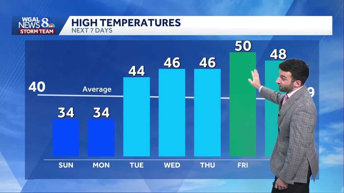
Clouds have stuck around for a large part of the day and will persist through tonight. Winds were slightly elevated earlier today, but have began to decrease heading into the evening. Temperatures will continue below average in the low 30s, and drop down through the mid 20s later this evening. A few snow flurries are possible later tonight as a wave of energy moves through the area. The air is dry so not much is expected.As high pressure builds in from the west, skies gradually clear by Sunday morning. We’ll begin the day with sunshine before some afternoon clouds bubble up. Overall skies are partly sunny. High temperatures peak in the mid 30s. The winds pick up out of the northwest 10 to 15 mph.There are plenty of clouds for the first couple of days of the new week, however, temperatures turn around, going from the 30s Monday to the 40s Tuesday.A disturbance skirting through the area Tuesday night into early Wednesday brings a few showers. There may be some mixing at higher elevations. Any accumulations will be light.There will be a series of fronts that bring showers late Thursday into Friday and again Saturday. Unfortunately for snow lovers, it will be wet not white. High temperatures will hover in the mid to upper 40s, maybe even a few 50s.Have a great rest of your evening!~ Ryan
Clouds have stuck around for a large part of the day and will persist through tonight. Winds were slightly elevated earlier today, but have began to decrease heading into the evening. Temperatures will continue below average in the low 30s, and drop down through the mid 20s later this evening. A few snow flurries are possible later tonight as a wave of energy moves through the area. The air is dry so not much is expected.
As high pressure builds in from the west, skies gradually clear by Sunday morning. We’ll begin the day with sunshine before some afternoon clouds bubble up. Overall skies are partly sunny. High temperatures peak in the mid 30s. The winds pick up out of the northwest 10 to 15 mph.
There are plenty of clouds for the first couple of days of the new week, however, temperatures turn around, going from the 30s Monday to the 40s Tuesday.
A disturbance skirting through the area Tuesday night into early Wednesday brings a few showers. There may be some mixing at higher elevations. Any accumulations will be light.
There will be a series of fronts that bring showers late Thursday into Friday and again Saturday. Unfortunately for snow lovers, it will be wet not white. High temperatures will hover in the mid to upper 40s, maybe even a few 50s.
Have a great rest of your evening!
~ Ryan