
Warmer & breezy Sunday, then rain & storm chances return late Sunday for south-central Pennsylvania
We end the day on a mainly clear and mild note. Sunday starts off dry, but rain and storm chances increase after sunset. We have the latest timing and forecast.
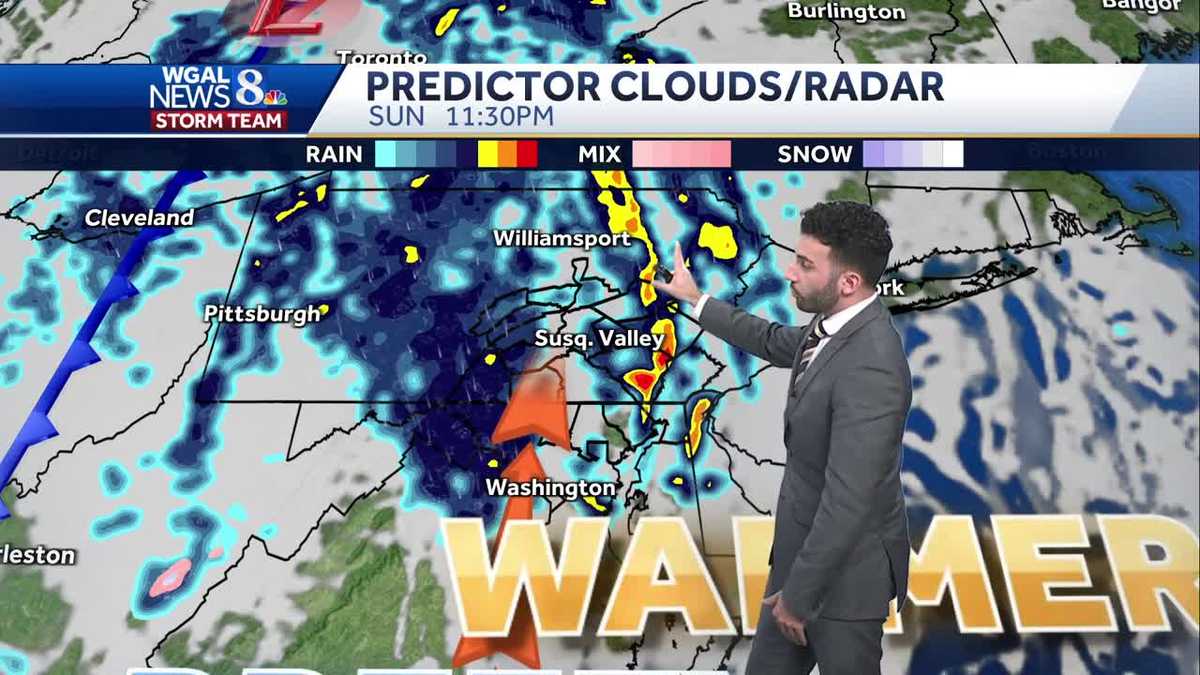
MORE THAN A DECADE. IT’S GOING TO BE A CALM NIGHT AS WE GET INTO THE OVERNIGHT PERIOD. I’D SAY PARTLY TO MAINLY CLEAR AS WE GET INTO THE OVERNIGHT, AS WE GET INTO THE OVERNIGHT HOURS. STILL A LITTLE BIT MILD, THOUGH FOR THIS TIME OF YEAR. BREEZY SUNDAY I WILL SAY WE’RE GOING TO BE SEEING SUSTAINED WINDS BETWEEN 10 TO 20MPH FOR TOMORROW AFTERNOON. COULD POTENTIALLY GUST TO 30MPH IN SOME ISOLATED AREAS. WARM INTO THE 70S. BUT I DID PUT AN IMPACT ICON HERE. THIS IS NOT FOR DURING THE DAY TOMORROW. DURING THE DAY IT’S GOING TO BE PARTLY SUNNY. IT WILL BE WARM AND BREEZY. THAT’S GOING TO BE THE MAIN STORY FOR THE AFTERNOON. AND INTO THE EVENING. TOWARD AFTER SUNSET IS WHAT WE’RE TALKING ABOUT IN TERMS OF THIS IMPACT NIGHT ICON. AS WE GET INTO OUR SUNDAY, WE’LL CHAT MORE ABOUT THE IMPACT NIGHT FORECAST HERE IN JUST A FEW MINUTES. MONDAY MORNING, LOOKING AT SOME SHOWERS, SOME LINGERING SHOWERS, THEN BREEZY ONCE AGAIN. HIGHS BACK TO THE 60S. FEELING MUCH MORE SEASONABLE TONIGHT. GETTING INTO THE 50S. PARTLY CLOUDY AND MILD. GOT A SOUTHEASTERLY 5 TO 10 MILE PER HOUR BREEZE FOR YOU. TOMORROW MORNING WE START PARTLY SUNNY. IT WILL BEGIN TO BECOME MORE BREEZY, STILL MILD INTO THE MID TO UPPER 50S APPROACHING THAT LOW 64 DEGREE MARK. ONCE WE GET INTO LATER IN THE MORNING, THEN WE’RE BUMPING UP TOWARDS THE 70S FOR THE AFTERNOON TOMORROW. LOOK AT THIS. THE WINDS SUSTAINED WINDS BETWEEN 10 TO 20MPH COULD GUST UP TO 30MPH. SO I KNOW FOLKS ARE GETTING SOME DECORATIONS OUT AND THEY’RE PUTTING THEM OUTSIDE. IF YOU HAVE DECOR ITEMS, YOU’RE YOU MIGHT WANT TO CONSIDER BRINGING THOSE INDOORS TEMPORARILY AS THIS NEXT COLD FRONT COMES THROUGH, WHICH IS GOING TO BE GIVING US THE POTENTIAL FOR SOME STORMS LATER IN THE NIGHT. AND SO THAT’S WHAT WE’RE WHAT WE’RE LOOKING OUT FOR AS WE GET INTO TOMORROW, 73 DEGREES AS WE GET INTO SATURDAY AFTERNOON OR I’M SORRY, EXCUSE ME, 73 WAS THE HIGH AS WE EARLIER THIS AFTERNOON. AVERAGE HIGH FOR THIS TIME OF YEAR IS RIGHT AROUND 65 DEGREES FOR FOR THIS TIME OF THE YEAR. WEATHER IN HELL FOR THE DAY TOMORROW. POLLEN LEVELS ARE LOW. MOLD LEVELS ARE LOW. AIR QUALITY IS MODERATE. GOT A LOW UV INDEX ABOUT A 50 MINUTE BURN TIME FOR YOU TOMORROW AFTERNOON, BUT YOU CAN SEE THE NEXT BEST CHANCES FOR RAIN ARE GOING TO BE LATE SUNDAY INTO EARLY MONDAY. THEN ONCE WE GET INTO THE AFTERNOON MONDAY, THAT’S WHEN THE PRECIPITATION CHANCES DO DROP OFF. WE DO HAVE A VERY LOW CHANCE, BY THE WAY, FOR TUESDAY FOR SOME SHOWERS, BUT IT’S VERY LOW AT THIS TIME. JUST WANTED TO ACCOUNT FOR IT THOUGH. AS WE GET INTO OUR TUESDAY TEMPERATURES INTO THE 50S RIGHT NOW, 60 DEGREES IN CHAMBERSBURG. CURRENT SUSTAINED WINDS OUT OF THE EAST RIGHT NOW. AND THEY’RE CALM. BUT THAT’S THAT’S NOT GOING TO BE THE SAME STORY THOUGH AS WE GET INTO TOMORROW AFTERNOON. THIS IS A THIS IS OUTSIDE OF THE STORMS THAT ARE THAT ARE FORECASTED TO COME IN. THIS IS WHAT’S GOING TO BE HAPPENING. AS YOU CAN SEE, THE TIME STAMP RIGHT IN THE AFTERNOON AND EARLY EVENING HOURS, 20 MILE PER HOUR SUSTAINED WIND IN HARRISBURG, JUST TO NAME ONE OF THOSE COMMUNITIES. STORM TEAM, LIVE RADAR NETWORK. ALL IS QUIET, ALL THANKS TO HIGH PRESSURE THAT’S SPRAWLING ACROSS THE EASTERN SEABOARD. BUT THIS IS WHAT I’M WATCHING AS WE GET INTO OUR SUNDAY, WE HAVE THIS LINE OF STORMS THAT COULD POSSIBLY COME IN, OR THAT WILL BE COMING IN AS WE GET INTO LATE IN THE EVENING. ON SUNDAY. LET’S TIME THINGS OUT FOR YOU. I’M GOING TO STOP THE CLOCK RIGHT HERE AT RIGHT AROUND 7:00. IN TERMS OF WHEN WE’RE EXPECTING THESE SHOWERS AND STORMS TO COME IN, IT’S RIGHT AROUND 7:00 WHERE YOU CAN SEE IT’S STARTING TO COME IN ON OUR WESTERN COUNTIES. PERSIST THROUGH THE LATE EVENING INTO THE OVERNIGHT PERIOD. YOU CAN SEE THE TIME STAMP RIGHT AROUND 1130 AT NIGHT, 12 A.M. COULD SEE SOME OF THAT SEVERE WEATHER OR THOSE STORMS COME THROUGH TOWARDS OUR EASTERN COMMUNITIES, TOWARDS LEBANON COUNTIES, LANCASTER COUNTY, DAUPHIN COUNTIES. JUST BE JUST BE ON ALERT UNTIL ABOUT 2 A.M. THEN WE ARE LOOKING AT SOME LINGERING SHOWERS FOR YOUR MONDAY MORNING COMMUTE. AND THEN ONCE WE GET INTO THE AFTERNOON, YOU CAN SEE SKIES CLEAR UP. WE DO SEE PARTLY TO MAINLY CLEAR CONDITIONS AS WE GET INTO OUR DAY ON MONDAY. SO FOR THE REST OF THE FORECAST, WE ARE LOOKING AT A POSSIBLE POSSIBLE SHOWER CHANCE FOR YOUR TUESDAY. BUT THEN WE ARE LOOKING AT SOME SEASONABLE CONDITIONS AS WE GET TO TUESD
Warmer & breezy Sunday, then rain & storm chances return late Sunday for south-central Pennsylvania
We end the day on a mainly clear and mild note. Sunday starts off dry, but rain and storm chances increase after sunset. We have the latest timing and forecast.

Updated: 11:42 PM EDT Oct 18, 2025
Tonight, sky cover will be on the increase, so we’ll have partly cloudy skies overnight. Lows are milder in the low to mid 50s.Another warm & breezy day is on tap for Sunday afternoon with partly sunny conditions. Southerly winds will be in the 10 to 20 mph range, with gusts pushing the 30 mph mark, which will assist in pushing highs back to the mid-70s. Rain chances hold off until after sunset.The Storm Prediction Center has highlighted the Susquehanna Valley in a Marginal Risk (a level 1 out of 5) for severe weather with damaging winds & heavy rain as the primary threats. As a slow-moving cold front approaches the area Sunday night, a line of showers and storms with gusty winds are expected to impact the Valley. Main timing is between 7 PM and 2 AM. Winds may gust to 30-40 mph with the passage of the front. With these storm threats in mind, the News 8 Storm Team has declared an Impact period for Sunday night from 7 PM – 2 AM. Also, if you have outdoor holiday decorations, such as inflatables or other items that may be unfastened, you may want to consider bringing decor items inside temporarily for Sunday night.Once the cold front pushes through, rain chances stick around from overnight Sunday into Monday morning as the upper-level system continues swinging through the Commonwealth. So for your Monday morning commute, expect some lingering showers up until around noon or 1 PM Monday afternoon. Skies become sunnier by Monday afternoon and will be cooler & breezy, thanks to west-northwest winds 10 to 20 mph. Winds may gust to 30 mph again for Monday. Highs will fall back to more seasonable norms in the low to mid 60s.Temperatures are in the mid 60s again on Tuesday, then another front is expected to knock temperatures down a bit into the upper 50s to low 60s the rest of the week.Have a great rest of your night!~ Ryan
Tonight, sky cover will be on the increase, so we’ll have partly cloudy skies overnight. Lows are milder in the low to mid 50s.
Another warm & breezy day is on tap for Sunday afternoon with partly sunny conditions. Southerly winds will be in the 10 to 20 mph range, with gusts pushing the 30 mph mark, which will assist in pushing highs back to the mid-70s. Rain chances hold off until after sunset.
The Storm Prediction Center has highlighted the Susquehanna Valley in a Marginal Risk (a level 1 out of 5) for severe weather with damaging winds & heavy rain as the primary threats. As a slow-moving cold front approaches the area Sunday night, a line of showers and storms with gusty winds are expected to impact the Valley. Main timing is between 7 PM and 2 AM. Winds may gust to 30-40 mph with the passage of the front. With these storm threats in mind, the News 8 Storm Team has declared an Impact period for Sunday night from 7 PM – 2 AM. Also, if you have outdoor holiday decorations, such as inflatables or other items that may be unfastened, you may want to consider bringing decor items inside temporarily for Sunday night.
Once the cold front pushes through, rain chances stick around from overnight Sunday into Monday morning as the upper-level system continues swinging through the Commonwealth. So for your Monday morning commute, expect some lingering showers up until around noon or 1 PM Monday afternoon. Skies become sunnier by Monday afternoon and will be cooler & breezy, thanks to west-northwest winds 10 to 20 mph. Winds may gust to 30 mph again for Monday. Highs will fall back to more seasonable norms in the low to mid 60s.
Temperatures are in the mid 60s again on Tuesday, then another front is expected to knock temperatures down a bit into the upper 50s to low 60s the rest of the week.
Have a great rest of your night!
~ Ryan