
Chilly & calm for Sunday, then watching more rain chances & milder temperatures next week in south-central Pennsylvania
Temperatures remain below average for the next couple days, but make a run for the 40s & 50s next week! Watch the Storm Team forecast to see when our next best chances for rain will be.
SO WHAT WE’RE TRACKING IS BEGINNING TO THE NEXT FEW DAYS, REALLY SEVERAL DAYS THROUGH MONDAY, WE’RE GOING TO BE STAYING CRISP AND CHILLY TUESDAY AND BEYOND. TEMPERATURES WILL BE TURNING AROUND TO THE 40S. WE’RE HOPPING ONTO A WARMING TREND, BUT THEN ALSO GETTING INTO NEXT WEEK. SEVERAL RAIN CHANCES WILL BE ON TAP FOR US STARTING RIGHT AROUND TUESDAY. WEDNESDAY TIME FRAME LATE TUESDAY INTO EARLY WEDNESDAY, AND ALSO GETTING INTO THE FOLLOWING WEEKEND. BUT WE’RE GOING TO CHAT ABOUT THAT HERE IN THE FULL FORECAST OVERNIGHT TONIGHT, MOSTLY CLOUDY CONDITIONS WILL HAVE. WE’LL START TO SEE MORE. SO SOME CLEARING BY THE MORNING TIME WITH STILL HAVE THAT SEASONAL CHILL IN THE AIR. TEMPERATURES RIGHT INTO THE LOWER 20S, 22 TO 26 DEGREES WITH NORTHWESTERLY 5 TO 10 MILE PER HOUR BREEZE. AND FOR TOMORROW MORNING, STILL CHILLY AND CRISP. BUT WE’LL START TO HAVE MORE OF THOSE INCREASING WINDS OUT OF THE NORTHWEST, STAYING RIGHT AROUND THE MID TO RIGHT AROUND THE MID 20S, I’D SAY UNDER MOSTLY SUNNY SKIES, BUT THEN TURNING BREEZY BY THE AFTERNOON. YOU CAN SEE INCREASING TO ABOUT A 10 TO 15 MILE PER HOUR BREEZE FOR THE AFTERNOON, SO STILL REMAINING PARTLY SUNNY, THOUGH WE HAVE A LITTLE BIT OF SOME ENERGY THAT’S GOING TO BE MOVING THROUGH LATE SUNDAY INTO MONDAY. THAT’S WHAT’S GOING TO BE CONTRIBUTING TO SOME OF THE INCREASING CLOUD COVER HEADING INTO OUR MONDAY. SO TEMPERATURES INTO THE 30S OR EXCUSE ME, WE HIT RIGHT AROUND 30 DEGREES TODAY FOR OUR SATURDAY. 39 IS WHAT WE EXPECT FOR THIS TIME OF YEAR. SO ABOUT NINE DEGREES BELOW AVERAGE FOR WHAT WE EXPECT FOR BEGINNING OF JANUARY. BUT WE’RE RIGHT AROUND PAR IN TERMS OF OVERNIGHT LOWS HIT ABOUT 22 DEGREES EARLIER THIS MORNING. 25 IS WHAT WE EXPECT. NO RAINFALL WAS RECORDED AT HARRISBURG INTERNATIONAL AIRPORT. SO THE QUADRANTID METEOR SHOWER BY THE WAY. SO THIS THIS USUALLY HAPPENS STARTS AROUND DECEMBER 28TH AND LASTS UP UNTIL ABOUT JANUARY 12TH. BUT I’M BRINGING IT UP NOW BECAUSE IT’S PEAKING TONIGHT, JANUARY 4TH. IT’S UP TO ABOUT 100 METEORS PER HOUR. THE BEST VIEWING IS GOING TO BE FROM MIDNIGHT TO DAWN, ALTHOUGH UNFORTUNATELY WITH THE MOON BEING OUT AND ALSO SOME OF THE THE THE CLOUDS BEING AROUND MIGHT BE SEEING SOME MORE. SO FAIR CONDITIONS. I STILL THINK WE’LL SEE SOME. YOU MAY SEE SOME CLEARING ALREADY. STARTING TO SEE SOME CLEARING ON SOME OF THE SKY CAMS RIGHT NOW, SO YOU MAY BE ABLE TO GET A PEEK AT SOME OF THESE METEOR SHOWERS. ALTHOUGH IT’S GOING TO BE MOSTLY CLOUDY OVERALL FOR TONIGHT, SO YOU MAY BE ABLE TO SEE SOMETHING, BUT IF YOU DO SEE SOMETHING, LET US KNOW. WE’LL BE WE’LL BE WATCHING THE COMMENTS. NOW CURRENT DROUGHT MONITOR. AT THIS TIME, THE MAJORITY OF THE AREA UNFORTUNATELY IS UNDER A MODERATE DROUGHT SITUATION. ALSO, SEEING SOME ABNORMALLY DRY CONDITIONS TOWARDS DAUPHIN, LEBANON AND LANCASTER COUNTIES. ALSO TOWARDS EASTERN PORTIONS OF YORK COUNTY AT THIS TIME. SO WE DEFINITELY NEED THE RAIN, ALTHOUGH THANKFULLY WE’RE GOING TO BE SEEING SOME MORE OF THOSE RAIN CHANCES FOR TUESDAY, WEDNESDAY AND ALSO FRIDAY AND SATURDAY OF NEXT WEEK. SO THAT’S SOME GOOD NEWS FOR US. HOPEFULLY WE CAN GET SO WE CAN PUT A LITTLE BIT OF A DENT IN SOME OF THAT, THAT DEFICIT THAT WE HAVE AT THIS TIME. BUT WE’RE INTO THE MID 20S FOR LANCASTER, LEBANON, LEWISTOWN AT THIS HOUR. YOU CAN SEE WINDS ARE CALM RIGHT NOW. BUT LOOK AT THIS. IT WILL BE A DIFFERENT STORY ONCE WE GET INTO TOMORROW. YOU CAN SEE WILL INCREASE TO ABOUT 10 TO 15MPH BY THE AFTERNOON. AND ALSO WATCHING A LITTLE BIT OF SOME UPPER LEVEL ENERGY THAT’S ALLOWING FOR SOME OF THESE SHOWERS, SNOW SHOWERS. VERY LIGHT IN NATURE THOUGH. HAVEN’T GOTTEN ANY SNOWFALL REPORTS QUITE YET. I’LL BE WATCHING THE COMMENTS, BUT AS OF NOW, JUST SEEING SOME REAL, JUST UPPER LEVEL FLURRIES THAT ARE HAPPENING, BUT WITH HIGH PRESSURE AROUND, IT’S KEEPING US DRY. IT WILL BE CLEARING US OUT FOR TOMORROW AFTERNOON, AND ONCE WE HAVE THIS SYSTEM THAT STARTS TO COME IN, OR THIS DISTURBANCE FROM OUR WEST STARTS TO COME IN, THAT’S GOING TO HELP INCREASE OUR CLOUDS. GETTING INTO MONDAY MORNING, ALSO LATER INTO OUR OR LATER INTO MONDAY MORNING MIGHT TRIGGER A LITTLE BIT OF A OF A SNOW CHANCE FOR OUR FAR NORTHERN COMMUNITIES. BUT THEN HERE COMES THE WARMER AIR FROM THE SOUTH. FOLKS WILL BE SEEING SOME VERY MILD TEMPERATURES HEADING INTO TUESDAY THROUGH FRIDAY OF NEXT WEEK. LOOK AT THAT. MAKING A RUN FOR 50 DEGREES IN THE TEN DAY FORECAST. ALSO TRACKING A FEW SHOWER CHANCES FROM WEDNESDAY OR TUESDAY NIGHT INTO EARLY WEDNESDAY. ANOTHER CHANCE OF S
Chilly & calm for Sunday, then watching more rain chances & milder temperatures next week in south-central Pennsylvania
Temperatures remain below average for the next couple days, but make a run for the 40s & 50s next week! Watch the Storm Team forecast to see when our next best chances for rain will be.

Updated: 12:10 AM EST Jan 4, 2026
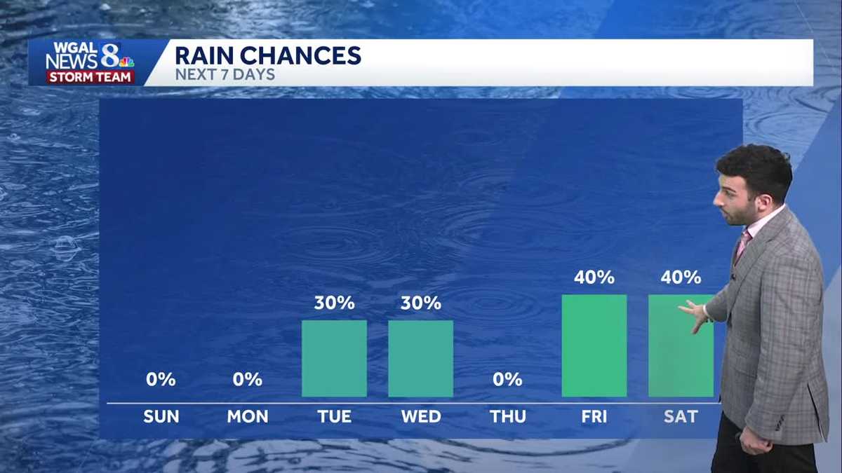
Cloudy conditions will persist through tonight with calm winds and temperatures dropping down to the lower 20s overnight. A few snow flurries are possible tonight as a wave of energy moves through the area. The air is dry so not much is expected to materialize.As high pressure builds in from the west, skies gradually clear by Sunday morning. We’ll begin the day with sunshine before some afternoon clouds bubble up. Overall skies are partly sunny. High temperatures peak in the mid 30s. The winds pick up out of the northwest 10 to 15 mph.There are plenty of clouds for the first couple of days of the new week, however, temperatures turn around, going from the 30s Monday to the 40s Tuesday.A disturbance skirting through the area Tuesday night into early Wednesday brings a few showers. There may be some mixing at higher elevations. Any accumulations will be light.There will be a series of fronts that bring showers late Thursday into Friday and again Saturday. Unfortunately for snow lovers, it will be wet not white. High temperatures will hover in the mid to upper 40s, maybe even a few 50s.Have a great rest of your night!~ Ryan
Cloudy conditions will persist through tonight with calm winds and temperatures dropping down to the lower 20s overnight. A few snow flurries are possible tonight as a wave of energy moves through the area. The air is dry so not much is expected to materialize.
As high pressure builds in from the west, skies gradually clear by Sunday morning. We’ll begin the day with sunshine before some afternoon clouds bubble up. Overall skies are partly sunny. High temperatures peak in the mid 30s. The winds pick up out of the northwest 10 to 15 mph.
There are plenty of clouds for the first couple of days of the new week, however, temperatures turn around, going from the 30s Monday to the 40s Tuesday.
A disturbance skirting through the area Tuesday night into early Wednesday brings a few showers. There may be some mixing at higher elevations. Any accumulations will be light.
There will be a series of fronts that bring showers late Thursday into Friday and again Saturday. Unfortunately for snow lovers, it will be wet not white. High temperatures will hover in the mid to upper 40s, maybe even a few 50s.
Have a great rest of your night!
~ Ryan