
Warming trend along with a couple rain chances return this week for south-central Pennsylvania
Temperatures remain below average another day but return to more seasonable norms Monday. With a pattern shift, 40s and 50s make a return this week. Next best chance for rain showers is late week.
AND NO FIREARM WAS FOUND AT THE SCENE. THE WEATHER HEADLINES AS WE GET INTO THE WORKWEEK, OR AS WE GET INTO THIS COMING WORKWEEK. IT’S GOING TO BE ANOTHER DAY OF SOME LOW 30S WITH SOME BELOW AVERAGE CHILLS. STILL SOME BREEZY WINDS THERE, BUT WE’LL FINALLY BE HOPPING ON TO A WARMING TREND WITH HIGH TEMPERATURES HEADING FOR THE 40S AND THE 50S. AS WE GET INTO THE MIDDLE OF THE WORKWEEK. THEN WE’RE STILL WE’RE STILL A LITTLE BIT OF A RAINFALL DEFICIT, SO WE DEFINITELY NEED SOME RAIN ACROSS THE AREA. BUT LUCKILY WE DO HAVE A COUPLE OF RAIN CHANCES AS WE GET INTO LATER IN THE WEEK. SO FOR THIS EVENING, EXPECT MOSTLY CLOUDY CONDITIONS WITH DIMINISHING WINDS. STILL A LITTLE BIT OF A OF A BREEZE OUT THERE RIGHT NOW. JUST SAW SOME OF THE SOME OF THE SKY CAMS STILL SEE A LITTLE BIT OF A BREEZE, BUT WE’LL STILL REMAIN MOSTLY CLOUDY FOR THE MAJORITY OF THIS EVENING. AND FOR TONIGHT, WE’LL STILL SEE THOSE MOSTLY CLOUDY CONDITIONS PERSIST. WE’LL HAVE THAT SEASONAL CHILL IN THE AIR WITH LOWS GETTING INTO THE LOW 20S. YOU CAN SEE THE THE MOSTLY CLOUDY ICON THERE FOR TONIGHT. THEN FOR TOMORROW WE’LL SEE SOME PARTIAL SUNSHINE. COULD SEE A FEW FLURRIES EARLY IN THE DAY. WE DO HAVE A LITTLE BIT OF SOME UPPER LEVEL ENERGY THAT’S GOING TO MAKE ITS WAY THROUGH, BUT I WOULD SAY WE HAVE PARTLY SUNNY CONDITIONS FOR THE AFTERNOON. BORDERLINE MOSTLY CLOUDY, BUT TEMPERATURES WILL BE INTO THE UPPER 30S. THIS IS WHEN WE’LL START TO SEE THAT MILDER TREND BEGIN TO KICK IN. SO STEELERS FORECAST BY THE WAY FOR THIS EVENING IT WILL BE THE RAVENS AGAINST THE STEELERS. EVERYBODY MOSTLY CLOUDY CONDITIONS WILL BE ON TAP 25 DEGREES RIGHT AROUND 7:00 AND STILL DRY RIGHT AROUND 9:00 AND 11:00. STILL COLD 25 DEGREES. SO IT’S VERY CHILLY OUT THERE. SO IF YOU’RE IF YOU’RE TUNING IN OR IF YOU’RE WATCHING THIS, IF YOU’RE WATCHING THIS LIKE A THE LIVE STREAM AND YOU’RE IN PITTSBURGH RIGHT NOW YOU’RE WATCHING THIS, MAKE SURE YOU HAVE THOSE HAND WARMERS IN THE THE EXTRA LAYERS, EXTRA GLOVES THAT YOU HAVE. IT’S DEFINITELY GOING TO BE A CHILLY REST OF THE EVENING AND CHILLY NIGHT TONIGHT. TEMPERATURES WERE REACHED RIGHT AROUND 33 DEGREES AT HARRISBURG INTERNATIONAL. 39 IS WHAT WE EXPECT FOR THIS TIME OF THE YEAR. SO A LITTLE BIT BELOW AVERAGE FOR THIS FOR THIS TIME OF THE YEAR IN JANUARY. BUT 26 DEGREES WAS THAT WAS EARLIER THIS MORNING’S LOW 24 DEGREES. THAT’S WHAT WE EXPECT FOR THIS TIME OF THE YEAR, ONLY HAD ABOUT A TRACE OF SOME RAINFALL RECORDED ON THE ON THE CLIMATOLOGICAL REPORT FROM THE AIRPORT. NOW CURRENT DROUGHT MONITOR. THIS IS WHY WE SAY THAT WE DEFINITELY NEED SOME RAIN, EVEN THOUGH WE’VE HAD SOME PAST SNOW CHANCES HAVE HAD SOME, YOU KNOW, WE HAD SOME SNOW IN THE PAST, BUT IT’S NOT ENOUGH WATER, NOT ENOUGH, NOT ENOUGH PRECIPITATION TO BE ABLE TO REALLY WET THE GROUND. FOR US, WE’RE DEALING WITH A BIT OF A MODERATE DROUGHT SITUATION BEGINNING TO DEVELOP AND SOME ABNORMALLY DRY CONDITIONS DEVELOPING TOWARDS DAUPHIN, LEBANON, YORK AND LANCASTER COUNTIES RIGHT NOW. BUT RAIN CHANCES THE NEXT SEVERAL DAYS. NOT THE BEST CHANCES FOR OUR TUESDAY AND INTO WEDNESDAY. THE TIME FRAME FOR THESE SHOWERS GOING TO BE LATE TUESDAY. EARLY WEDNESDAY MORNING, I’D SAY ENDING BY 3:00 IN THE MORNING. THAT’S HOW LATE WE’RE TALKING ABOUT. AND THEN FRIDAY AND SATURDAY, THAT’S GOING TO BE THE BETTER OF THE CHANCES FOR RAIN. THAT’S WHAT THAT’S WHERE WE’RE REALLY GOING TO BE WATCHING FOR MORE RAIN CHANCES, TEMPERATURES INTO THE 30S. YOU CAN SEE 28 IN YORK, 28 IN LEWISTOWN. YOU CAN SEE WE ALSO HAVE A LITTLE BIT OF A BREEZE STILL IN THE IN THE AIR. SO IT’S THAT’S WHAT’S CONTRIBUTING TO FEELS LIKE TEMPERATURES FEELING MORE SO INTO THE 20S RATHER THAN THE 30S. IN SOME COMMUNITIES. YOU CAN SEE MOSTLY CLOUDY CONDITIONS OVER THE AREA WILL WIDEN OUT THE PICTURE. YOU CAN SEE A LITTLE BIT OF A DISTURBANCE TOWARDS NEW YORK STATE AT THIS TIME, BUT WE’RE JUST SEEING SOME SOME MOSTLY CLOUDY CONDITIONS DEVELOPING, EVEN THOUGH WE HAVE A LITTLE BIT OF HIGH PRESSURE BUILDING IN. THAT’S WHAT MAY ALLOW FOR SOME PARTIAL CLEARING FOR THE AFTERNOON TOMORROW, BUT I’M NOT REALLY EXPECTING ANY ABUNDANT SUNSHINE FOR THE AFTERNOON AND THE EVENING. BUT THEN HERE COMES. HERE COMES THE MILDER AIR FROM THE SOUTH. THAT’S WHAT’S GOING TO BE PUSHING OUR TEMPERATURES TO THE 40S AND EVENTUALLY TOWARDS THE 50S. BY THE TIME WE GET TO OUR WEDNESDAY. NOW, I DO WANT TO POINT OUT, HERE’S WHEN THOSE FEW SHOWER CHANCES START TO COME IN, RIGHT AROUND 8:00, 9:00 IN THE EVENING TUESDAY. THAT’S WHEN WE’LL START TO SEE SOME OF THOSE SHOWERS COME THROUGH AND ALLOW FOR THAT SHOWER CHANCE. BUT WE HAVE BETTER CHANCES FOR SHOWERS FOR FRIDAY AND SATURDAY. BUT LOOK AT THIS. LOOK AT THIS TEMPERATURE TREND 50 DEGREES IN THE AVERAGE FOR THIS TIME OF YEAR, BY THE WAY, IS LIKE 40 DEGREES. ALSO 39 DEGREES BY NEXT SUNDAY. SO DEFINITELY GOING TO BE A MILD WEEK COMING UP. SO ENJOY IT. IF YOU’RE A WARM WEATHER LOVER, DO HAVE A CHANCE OF SOME OF THOSE SHOWERS FOR YOUR TUESDAY NIGHT, FRIDAY AND SATURDAY. LOOKING AHEAD INTO THE FOLLOWING WEEK, THOUGH, THIS MILDER TREND DOES NOT LAST. WILL BE GOING BACK DOWN TOWARDS THE 30
Warming trend along with a couple rain chances return this week for south-central Pennsylvania
Temperatures remain below average another day but return to more seasonable norms Monday. With a pattern shift, 40s and 50s make a return this week. Next best chance for rain showers is late week.

Updated: 6:31 PM EST Jan 4, 2026
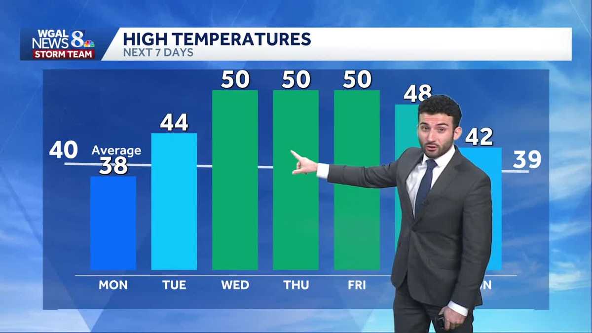
Expect increasing clouds ahead of some upper level energy that will pass through overnight tonight into Monday morning. Temperatures will drop through the upper 20s with winds diminishing out of the northwest.The next shortwave brings clouds back tonight into early Monday. A few flurries in northwestern counties are possible the chance is very low. Lows are in the mid 20s. Sunshine increases during the afternoon and highs are more seasonable in the upper 30s.Another disturbance approaches the area on Tuesday bringing plenty of cloud cover for the day. There may be a few showers late towards evening. We’ll watch for some light mixing at higher elevations. Overall, there isn’t much moisture with the system. Highs are milder and above average in the low 40s.Early clouds give way to brighter skies during the afternoon Wednesday. After a mild start in the low to mid 30s, and warmer air surging into the area, temperatures easily climb to near 50 degrees.Thursday is dry and mild in the upper 40s under partly sunny skies.Our best chances for showers are Friday and Saturday, as a couple of frontal boundaries cross the Susquehanna Valley. It is mild both days but colder moves inHave a great day!
Expect increasing clouds ahead of some upper level energy that will pass through overnight tonight into Monday morning. Temperatures will drop through the upper 20s with winds diminishing out of the northwest.
The next shortwave brings clouds back tonight into early Monday. A few flurries in northwestern counties are possible the chance is very low. Lows are in the mid 20s. Sunshine increases during the afternoon and highs are more seasonable in the upper 30s.
Another disturbance approaches the area on Tuesday bringing plenty of cloud cover for the day. There may be a few showers late towards evening. We’ll watch for some light mixing at higher elevations. Overall, there isn’t much moisture with the system. Highs are milder and above average in the low 40s.
Early clouds give way to brighter skies during the afternoon Wednesday. After a mild start in the low to mid 30s, and warmer air surging into the area, temperatures easily climb to near 50 degrees.
Thursday is dry and mild in the upper 40s under partly sunny skies.
Our best chances for showers are Friday and Saturday, as a couple of frontal boundaries cross the Susquehanna Valley. It is mild both days but colder moves in
Have a great day!