
Seasonable Monday; Warming Trend Throughout The Week In South Central Pennsylvania
High temperatures on Monday will reach the upper 30s with a few early morning flurries. Warmer-than-average temperatures stick around for the rest of the week.
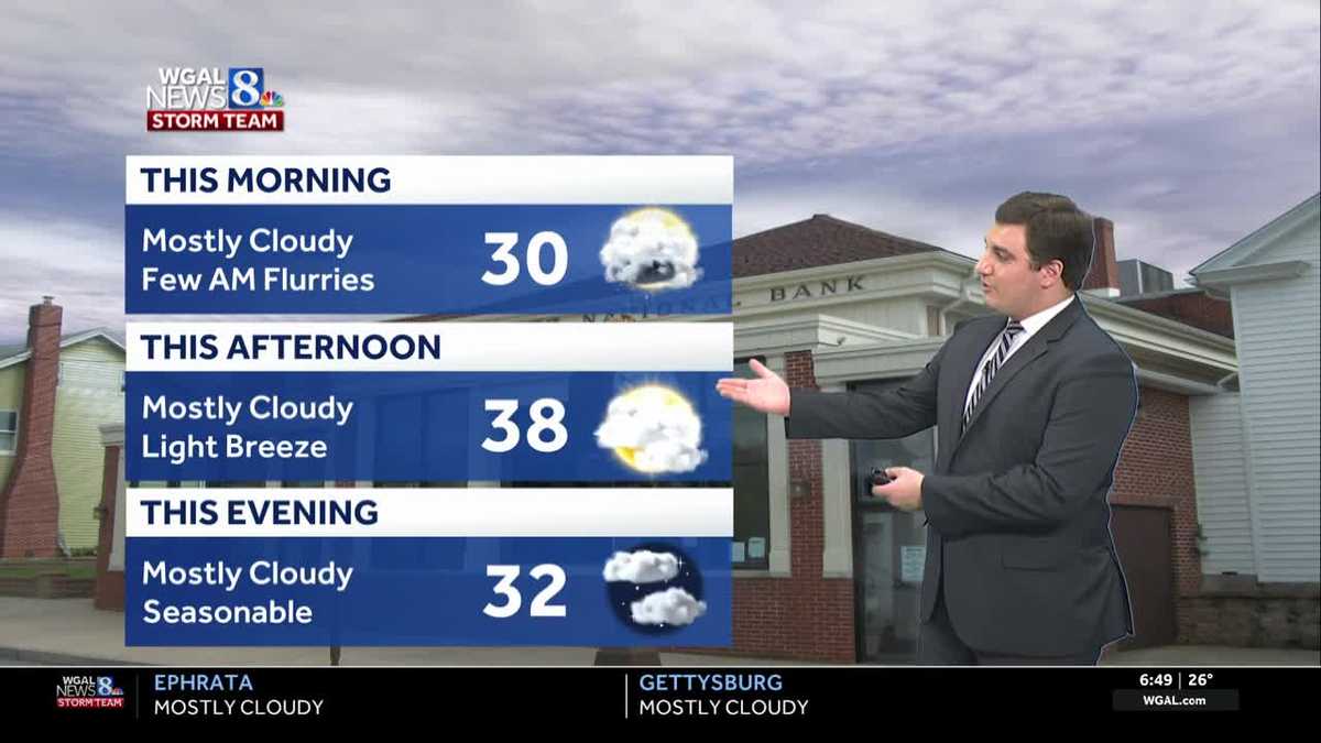
WE ARE TRACKING A FEW MORNING FLURRIES ACROSS THE AREA HERE. OTHERWISE IT’S GOING TO BE SEASONABLE TODAY. HIGHS IN THE UPPER 30S RIGHT WHERE WE SHOULD BE FOR THIS TIME OF YEAR. AS WE GO LATER IN THE WEEK THOUGH, WE FINALLY SEE A WARMING TREND. WE’RE GOING TO HAVE A STRETCH OF 50S COMING OUR WAY THE FIRST TIME ACTUALLY, SINCE JUST BEFORE THANKSGIVING AND LATER IN THE WEEK, RAIN CHANCES WILL ALSO GO UP. WE DO NEED THE RAIN AND WE WILL HAVE SOME WIDESPREAD RAIN AS WE HEAD TOWARDS FRIDAY AND SATURDAY TO END THE WEEK. BUT RIGHT NOW THROUGH THE DAY TODAY YOU’RE LOOKING AT TEMPERATURES GOING FROM 30 DEGREES THIS MORNING WITH A FEW MORNING FLURRIES UP TO 38 THIS AFTERNOON UNDER A MOSTLY CLOUDY SKY AND A LIGHT BREEZE. SO THERE WILL BE A LITTLE BIT OF A WIND CHILL THIS AFTERNOON, BUT NOT TOO BAD. TONIGHT MOSTLY CLOUDY. IT’S SEASONABLE LIGHT WINDS WITH TEMPERATURES IN THE UPPER 20S AND THAT MOSTLY CLOUDY SKY. TOMORROW THE MOSTLY CLOUDY SKY WILL CONTINUE. THERE WILL BE SOME SHOWERS LATE TOMORROW EVENING, BUT NOTHING THAT’S GOING TO BE WIDESPREAD OR TOO IMPACTFUL. WE’LL BE WARMER SOUTH THOUGH FOR OUR AREAS HERE. IF YOU ARE SOUTH OF A WARM FRONT TOMORROW YOU WILL GET INTO THE 50S. NORTH OF THAT, YOU’RE LOOKING AT 40S FOR YOUR TUESDAY. HERE’S A LOOK OUTSIDE LANCASTER. RIGHT NOW. WE’RE STARTING TO SEE A LITTLE BIT OF THAT SUNRISE HERE, TRYING TO PEAK OUT THERE BEHIND SOME OF THE CLOUDS. AND THE SUNRISE TODAY IS 730 IN THE MORNING. THIS IS ACTUALLY THE LATEST. THE SUNRISE OCCURS HERE IN THE SUSQUEHANNA VALLEY. THAT WILL CONTINUE UNTIL THURSDAY. AND THEN WE START TO SEE THE SUNRISE GET EARLIER AND EARLIER. FROM THAT POINT ON HERE, AS WE HEAD TOWARDS THE REST OF WINTER. BUT TEMPERATURES RIGHT NOW, 26 IN HARRISBURG, 24 IN LANCASTER, AS WELL AS LEBANON, CARLISLE, GETTYSBURG, YOU’RE BOTH SITTING AT 27. THE COLD SPOT IS YORK WITH A PAIR OF TWOS AT 22. STORM TEAM LIVE RADAR SHOWING A FEW FLURRIES AROUND THIS MORNING, ESPECIALLY UP BY LEWISTOWN. THERE, MIFFLIN AND JUNIATA COUNTY. SO DON’T BE SURPRISED IF YOU SEE SOME OF THAT OF THIS THIS MORNING AS YOU ARE HEADING OFF TO WORK AND SCHOOL. WE ARE SEEING MORE STEADY PRECIPITATION TO THE NORTH THAT STAYS TO THE NORTH AS WE GO THROUGH THE DAY TODAY HERE IN THIS MORNING. SO WE WILL NOT SEE ANYTHING IMPACTFUL TODAY. JUST ENOUGH FOR MAYBE SEE A FEW FLAKES FLYING AND THAT’S IT. THE REST OF THE DAY LOOKING DRY, MAYBE EVEN SOME SUNSHINE COMING OUT LATER ON THIS AFTERNOON. HERE. MILDER CONDITIONS. TRY TO SET UP HERE AS WE GO INTO TUESDAY, BUT THE PROBLEM IS THAT THIS BOUNDARY DROPS TO THE SOUTH, SO IT KEEPS ALL THAT MILDER AIR LOCKED TO THE SOUTH. HERE, AS WE GO INTO YOUR TUESDAY, IF YOU GET NORTH OR THAT FRONT PASSES NORTH OF YOU, YOU GET THE MILD AIR. YOU WILL BE IN THE 50S. BUT IF YOU ARE JUST NORTH OF THIS WARM FRONT IN RED, YOU’RE STAYING IN THE 40S HERE. SO IT’S GOING TO BE RIGHT SOMEWHERE ACROSS OUR AREA. LOOKS LIKE IF YOU’RE SOUTH OF ROUTE 30, YOU HAVE THE BEST CHANCE OF GETTING THE 50S TOMORROW. YOU DON’T GET IT TOMORROW. NO WORRIES. WE WILL SEE A WARMER PATTERN SETTING UP AS WE GO INTO WEDNESDAY AND BEYOND HERE. WEDNESDAY LOOKING LIKE A DRY DAY. AND THAT’S WHERE I THINK MOST OF US ACTUALLY DO SEE AROUND 50 DEGREES. COULD SEE THREE DAYS OR MORE FOR FIRST TIME SINCE NOVEMBER. AND AS WE GO INTO YOUR FRIDAY, WE GET TO 50S AGAIN. SOME RAIN FOR THE END OF THE WEEK AND INTO SATURDAY, BOTH DAYS LOOKING QUITE RAINY ACROSS THE AREA. AND THEN WE GET A REALITY CHECK STARTING SUNDAY AND THEN UPPER 30S RET
Seasonable Monday; Warming Trend Throughout The Week In South Central Pennsylvania
High temperatures on Monday will reach the upper 30s with a few early morning flurries. Warmer-than-average temperatures stick around for the rest of the week.

Updated: 7:51 AM EST Jan 5, 2026
Good morning,We start off the work week with a mostly cloudy sky. Some upper-level energy will pass over the Susquehanna Valley, potentially leading to a few flurries during the morning commute. Sunshine increases during the afternoon, and highs are more seasonable in the upper 30s. Monday will be the coldest day of the week before a warmer pattern sets up across Pennsylvania.Monday night will be seasonably chilly with temperatures in the mid/upper 20s under a mostly cloudy sky. The mostly cloudy sky will continue on Tuesday as a warm front approaches from the west. The placement of the warm front will be important for our high temperatures. Areas south of the warm front will make a run for the 50s, while those north of the boundary stay well into the 40s. Another disturbance is expected to approach the area on Tuesday evening, bringing a few showers to the area. We’ll watch for some light mixing at higher elevations, but no accumulation or impacts are expected.Early clouds give way to brighter skies during the afternoon on Wednesday. After a mild start in the low to mid 30s, and warmer air surging into the area, temperatures easily climb to near 50 degrees.The warmer-than-average trend continues for the end of the week! Thursday is dry and mild in the low 50s under a partly sunny sky. Our highs remain in the 50s for Friday and Saturday as well.Our best chances for showers are Friday and Saturday, as a couple of frontal boundaries cross the Susquehanna Valley. Sunday will be drier, but cooler and windy. Our streak of 50s comes to an end with highs back into the low 40s. A more seasonable pattern sets up for the following week with highs in the upper 30s. Have a great day!
Good morning,
We start off the work week with a mostly cloudy sky. Some upper-level energy will pass over the Susquehanna Valley, potentially leading to a few flurries during the morning commute. Sunshine increases during the afternoon, and highs are more seasonable in the upper 30s. Monday will be the coldest day of the week before a warmer pattern sets up across Pennsylvania.
Monday night will be seasonably chilly with temperatures in the mid/upper 20s under a mostly cloudy sky.
The mostly cloudy sky will continue on Tuesday as a warm front approaches from the west. The placement of the warm front will be important for our high temperatures. Areas south of the warm front will make a run for the 50s, while those north of the boundary stay well into the 40s. Another disturbance is expected to approach the area on Tuesday evening, bringing a few showers to the area. We’ll watch for some light mixing at higher elevations, but no accumulation or impacts are expected.
Early clouds give way to brighter skies during the afternoon on Wednesday. After a mild start in the low to mid 30s, and warmer air surging into the area, temperatures easily climb to near 50 degrees.
The warmer-than-average trend continues for the end of the week! Thursday is dry and mild in the low 50s under a partly sunny sky. Our highs remain in the 50s for Friday and Saturday as well.
Our best chances for showers are Friday and Saturday, as a couple of frontal boundaries cross the Susquehanna Valley. Sunday will be drier, but cooler and windy. Our streak of 50s comes to an end with highs back into the low 40s.
A more seasonable pattern sets up for the following week with highs in the upper 30s.
Have a great day!