
Impact Days with Rain and Gusty Winds for Pittsburgh
518 IMPACT DAY FOR US TODAY. NOT TOO BAD OF A START FOR US, BUT WE’LL STILL HAVE SOME SCATTERED SHOWERS AND SOME GUSTY WINDS TODAY. MORE WIDESPREAD RAIN, SOME POCKETS OF HEAVIER RAIN ON SATURDAY. IT WILL BE BREEZY AND WARM THEN A BIG SHOCK TO THE SYSTEM ON SUNDAY AS THOSE TEMPERATURES DROP BACK DOWN TO THE JANUARY FEEL DOWN INTO THE 30S. WIND CHILLS INTO THE TEENS. ON TOP OF IT, WE’RE GOING TO THROW IN SOME FLAKES AS WELL. I’LL BE TIMING THAT OUT HERE JUST ABOUT A MINUTE OR SO. BUT LOOK AT THESE TEMPERATURES THIS MORNING. IT FEELS REALLY NICE OUT 54 WAKING UP IN PITTSBURGH AND WASHINGTON, GREENSBURG AT 5553 INTO KITTANNING. FRANKLIN, YOU’RE AT 50 DEGREES A LITTLE BIT COOLER THERE IN THOSE HIGHER ELEVATIONS. SOMERSET AT 43. BUT WE’RE GOING TO BE PAYING ATTENTION TO THOSE WINDS GUSTING 25 TO SOME SPOTS, EVEN THE AFTERNOON, UP TO 35MPH. IT IS GOING TO GET A BIT ON THE BREEZY SIDE, AS THIS COLD FRONT WILL BE APPROACHING. NOW WE DO HAVE SOME DRIER AIR IN PLACE. THAT’S GOOD. WE WANT IT TO EAT UP THE RAIN. OUR GROUND IS ALREADY SO SATURATED, WE ARE STILL SEEING SOME OF THOSE SHOWERS INTO AKRON AND CLEVELAND PUSHING NORTHWARD. BUT TAKING A LOOK JUST TO OUR WEST, YOU CAN SEE THAT WELL-DEFINED LINE THAT FRONT WILL BE MOVING THROUGH AS WE GET INTO THE AFTERNOON. THAT’S REALLY WHEN THOSE WINDS ARE GOING TO START TO RAMP UP. SO WE’LL BE IN THE LOW 60S TODAY, 50S ON SATURDAY WITH SOME RAIN. AND THEN AGAIN, TEMPERATURES WILL BE DROPPING. THOSE WIND CHILLS WILL BE INTO THE TEENS. WHAT LOOKS NICE THOUGH IS OUR STEELERS FORECAST, WHICH HAS BEEN HOLDING STRONG PRETTY MUCH ALL WEEK LONG. PARTLY CLOUDY SKIES, COLD A LIGHT BREEZE, WIND CHILLS WILL BE INTO THE 20S, SO NOT TOO BAD FOR US, BUT OVERALL IT SHOULD BE A NICE NIGHT FOR SOME FOOTBALL. SO LET’S TIME OUT THIS RAIN TODAY. WE’LL SEE A FEW ISOLATED SHOWERS SIX 7:00 INTO LAWRENCE, ALSO INTO MERCER VENANGO THOSE SHOWERS THAT ARE OUT NEAR CLEVELAND COULD CLIP SOME OF OUR COUNTIES NORTH. AND THAT’S REALLY WHERE WE COULD STILL SEE SOME OF THAT RAIN AROUND SEVEN, 8:00. AND THEN VERY HIT OR MISS, BUT THREE, 4:00, NOT SO MUCH WORRIED ABOUT THE RAIN, BUT THOSE WINDS THAT DO PICK UP, ESPECIALLY AS KIDS ARE COMING HOME FROM SCHOOL AS THAT FRONT SWEEPS THROUGH A FEW BREAKS IN THE CLOUDS. THAT’S SHORT LIVED. WE WILL HAVE MOSTLY CLOUDY SKIES AND THIS HAS BEEN CONSISTENT AS WELL. A PRETTY DRY START FOR THE EARLY MORNING ON SATURDAY. THEN THIS RAIN IS GOING TO SWEEP IN. THIS LOW IS COMING IN FROM THE SOUTH. THAT’S WHAT’S WREAKING HAVOC DOWN NEAR TEXAS AND ALSO IN THE LOUISIANA. BUT WE’RE GOING TO HAVE THE RAIN AROUND LUNCHTIME, LATE MORNING, LUNCH HOUR, POCKETS OF HEAVY RAIN 4 OR 5:00, AND THEN EXPECTING THAT TO ROLL ON OUT. HERE COMES THE COLD AIR. A LITTLE SUNSHINE TO KICK OFF OUR SUNDAY. THEN WE’LL HAVE THOSE FLAKES FLYING AROUND. IT ALL DEPENDS ON THE WIND DIRECTION, BUT RIGHT NOW WE COULD SEE SOME LAKE ENHANCED SNOW SHOWERS, ESPECIALLY NORTH AND EAST. STILL DOES NOT LOOK LIKE A WHOLE LOT OF ACCUMULATION AROUND THE AREA. AGAIN, THIS COULD CHANGE IF THOSE WINDS DO SHIFT MORE WESTERLY, BUT OVERALL WE COULD SEE ABOUT A COATING TO A HALF AN INCH A LITTLE BIT HIGHER UP ALONG I-80 AND INTO THOSE MOUNTAINS EAST. WE’LL TAKE A LITTLE DIP WHEN WE REBOUND BACK UP INTO THE 40S. AS WE HEAD INTO TUESDAY AND WEDNESDAY. SO WE WILL BE WATCHING WEDNESDAY. THE TIMING OF THE RAIN COMING IN AT THE ONSET OF IT COULD HAVE A FEW FLAKES AS THOSE TEMPERATURES WILL
The spring-like temperatures will usher in rain changes for today and Saturday, which are both Impact Days. The weekend will end feeling like January again.Impact Days Heading into the WeekendFriday will be the warmest day of the week with highs in the low 60s. It will also turn breezy with winds gusting up to 30+ mph. Rain showers arrive today, making it an Impact Day. A few showers late this morning but a cold front will bring stronger wind gusts and a line of showers by the afternoon. Another system, arriving from the south, will send more rain our way on Saturday. Models show periods of rain are possible for Western PA. Continuing to watch the position of the low, but it still looks like the rain will arrive late morning on Saturday with pockets of heavy rain into the afternoon. Back to the January feelingThe set up for the end of the weekend certainly says January with colder air, gusty winds, and bursts of snow. Our high temperature on Sunday will happen at midnight with temperatures falling through the day. Factoring in the wind, it will feel like the 10s throughout the afternoon. Scattered flurries and snow showers will across the Pittsburgh area with little accumulation. Visibility would be more problematic as the bursts of snow hit. Steadier snow showers are possible north of I-80 and in the Laurel Highlands due to lake enhancement.Steelers Playoff GameThe seasonal temperatures will be around for the Monday night’s wild card game as the Steelers host the Texans. It will be dry with temperatures in the low 30s for the game.Temperatures will stay chilly next week. We are watching a system that may evolve with a rain and snow potential for the middle of next week.image id=’5bbe5434-93d3-44d8-87fa-5e5c419af963′ mediaId=’4adecdd7-dd3a-4b9c-a6b8-e0820b36cde8′ align=’center’ size=”medium” share=”true” caption=” expand=” crop=’original’][/image]TODAY: Impact Day. Cloudy with off and on scattered rain showers. High: 61°, low: 38°.SATURDAY: Impact Day. Cloudy with rain at times. Breezy and mild. High: 50°, low: 35°.SUNDAY: Windy and colder with bursts of snow. Falling temperatures with a midnight high of 35° and afternoon temperatures in the 20s. Wind chills will be in the teens.
The spring-like temperatures will usher in rain changes for today and Saturday, which are both Impact Days. The weekend will end feeling like January again.
Impact Days Heading into the Weekend
Friday will be the warmest day of the week with highs in the low 60s. It will also turn breezy with winds gusting up to 30+ mph.

Rain showers arrive today, making it an Impact Day. A few showers late this morning but a cold front will bring stronger wind gusts and a line of showers by the afternoon.
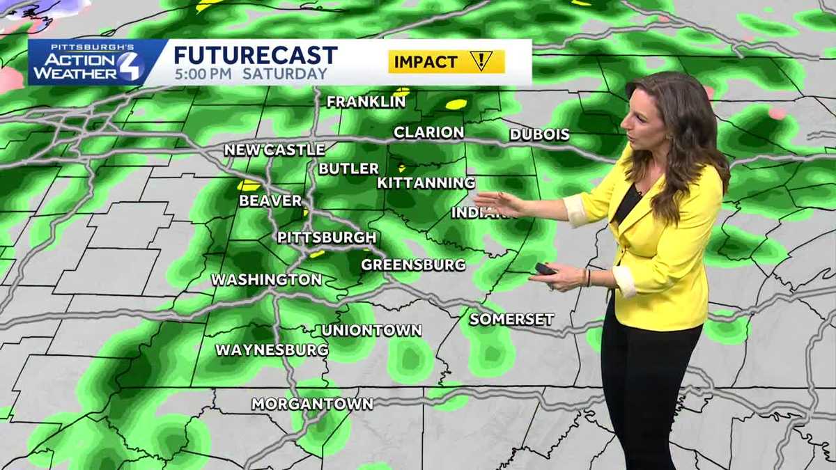
Another system, arriving from the south, will send more rain our way on Saturday. Models show periods of rain are possible for Western PA. Continuing to watch the position of the low, but it still looks like the rain will arrive late morning on Saturday with pockets of heavy rain into the afternoon.
Back to the January feeling
The set up for the end of the weekend certainly says January with colder air, gusty winds, and bursts of snow. Our high temperature on Sunday will happen at midnight with temperatures falling through the day. Factoring in the wind, it will feel like the 10s throughout the afternoon. Scattered flurries and snow showers will across the Pittsburgh area with little accumulation. Visibility would be more problematic as the bursts of snow hit. Steadier snow showers are possible north of I-80 and in the Laurel Highlands due to lake enhancement.
Steelers Playoff Game
The seasonal temperatures will be around for the Monday night’s wild card game as the Steelers host the Texans. It will be dry with temperatures in the low 30s for the game.

Temperatures will stay chilly next week. We are watching a system that may evolve with a rain and snow potential for the middle of next week.
image id=’5bbe5434-93d3-44d8-87fa-5e5c419af963′ mediaId=’4adecdd7-dd3a-4b9c-a6b8-e0820b36cde8′ align=’center’ size=”medium” share=”true” caption=” expand=” crop=’original’][/image]
TODAY: Impact Day. Cloudy with off and on scattered rain showers. High: 61°, low: 38°.
SATURDAY: Impact Day. Cloudy with rain at times. Breezy and mild. High: 50°, low: 35°.
SUNDAY: Windy and colder with bursts of snow. Falling temperatures with a midnight high of 35° and afternoon temperatures in the 20s. Wind chills will be in the teens.