
Impact weekend for Pittsburgh: More rain then winter returns
Colder air, gusty winds, and light snow are ahead for Sunday, another Impact Day.
BACK. 518 IS OUR TIME ON THIS SATURDAY MORNING. IT’S AN IMPACT DAY, SO LET’S GET YOU ANOTHER CHECK OF YOUR CERTIFIED MOST ACCURATE FORECAST. NOT ONLY IS TODAY AN IMPACT DAY, BUT ANOTHER ONE TOMORROW AS WELL. WE ARE GOING TO SEE A BIT OF A ROLLER COASTER RIDE AS WE GO THROUGH THIS WEEKEND. THE THOUGHT WAS GREAT WHILE WE HAD IT, BUT WE ARE HEADING BACK TO JANUARY LIKE CONDITIONS TODAY. MORE RAIN CHANCES ARE IN STORE GOING TO BE A BIT BETTER THAN IT WAS YESTERDAY, ESPECIALLY AS WE WORK INTO THE LATTER STAGE OF YOUR AFTERNOON. THEN, AS WE LOOK AHEAD TO SUNDAY. COLD, WINDY. ALSO SOME SNOW COMING INTO THE PICTURE AS WELL. YESTERDAY TEMPERATURES WERE WELL INTO THE 60S. FELT GREAT. BY TOMORROW AFTERNOON IT’S ONLY GOING TO FEEL LIKE THE TEENS I KNOW. I HATE TO BE THE BEARER OF BAD NEWS, BUT WE ARE GOING TO BE SETTLING INTO MORE OF A JANUARY LIKE PATTERN THAT WILL EXTEND INTO NEXT WEEK, BUT AT LEAST WE’RE DRY FOR OUR STEELERS MONDAY. I’LL BE BREAKING DOWN THAT FORECAST HERE IN JUST A MOMENT. PLENTY OF CLOUDS ACROSS WESTERN PENNSYLVANIA AS WE KICK OFF ONE OF TWO IMPACT DAYS THIS WEEKEND. RAIN IS STILL WELL TO OUR SOUTH INTO WEST VIRGINIA, BUT THAT WILL ARRIVE AS WE GET A LITTLE DEEPER INTO THIS MORNING. FOR SOME OF YOU NEAR THE WEST VIRGINIA BORDER, MAYBE CLOSER TO 9:00. SOME OF THAT RAIN COULD BE HEAVY AT TIMES, BUT YOU’LL SEE ON FUTURECAST AS WE WORK THROUGH THIS IMPACT DAY TOMORROW. ALSO NOW AN IMPACT DAY. AND THAT’S NOT ONLY THE COLD IN THE WIND, BUT ALSO SOME SNOW CHANCES. NOT EXPECTING A WHOLE LOT OF ACCUMULATION. BUT AS WE’VE SEEN, SOME OF THOSE SNOW SQUALLS ENOUGH TO REALLY DROP VISIBILITY, THAT COULD BE A BIG ISSUE. AND THEN YOUR 4-DAY PLUS 4 MORE FORECAST WE ARE SETTLING BACK INTO THE 40S, EVEN THE 20S AND 30S FOR HIGH TEMPERATURES. WE SLIDE INTO NEXT WEEK. RIGHT NOW, THE WIND IS CALMING DOWN, MAKING IT FEEL LIKE 32, EVEN THOUGH OUR TEMPERATURES AT 37 UNDER THOSE MOSTLY CLOUDY SKIES, ALL IS DRY, BUT NOT FOR LONG. HERE’S WE ADVANCE THROUGH THE MORNING ON FUTURECAST. YOU CAN SEE AFTER ABOUT NINE 10:00 SOME SCATTERED SHOWERS STARTING TO SHOW UP IN AND AROUND THE CITY OF PITTSBURGH. EVEN AROUND WASHINGTON. GREENSBURG TO STEADIER RAIN IS STILL SOUTH OF I-70, BUT THAT WILL CONTINUE TO BUILD IN TAKING OVER AS WE APPROACH THE AFTERNOON. SO IF YOU HAVE SOME PLANS THIS AFTERNOON, YOU WILL NEED THE RAIN GEAR. IT’S GOING TO BE MILD TEMPERATURES STILL AROUND 50, BUT PLENTY WET AS WE WORK THROUGH THE SECOND HALF OF THE DAY. EVEN INTO THIS EVENING, PROBABLY AFTER 9:00 TONIGHT, WE’LL START TO SEE THAT RAIN COMING TO AN END. THAT’S GOING TO BE WITH THE COLD FRONT THAT WILL DROP THOSE TEMPERATURES IN A HURRY. NUMBERS, IN FACT, WILL BE FALLING IF NOT HOLDING STEADY THROUGH MOST OF THE DAY. ON SUNDAY. WINDS ARE GOING TO PICK UP. COULD BE TALKING ABOUT SOME GUSTS BETWEEN 25 AND 40MPH. SO THAT’S GOING TO BLOW A LOT OF THE SNOW AROUND. IT STARTS TO DEVELOP INTO THE AFTERNOON. YOU CAN SEE SOME SCATTERED ACTIVITY AROUND 4:00 SUNDAY. SO SOMETHING TO BE MINDFUL OF AS WE ARE WRAPPING UP THIS WEEKEND IN TERMS OF ACCUMULATIONS TOMORROW. AGAIN, NOT EXPECTING A WHOLE LOT. MOST OF US ARE GOING TO STAY UNDER AN INCH EXCEPT FOR THOSE TYPICAL ZONES UP ALONG I-80, ALSO INTO THE LAUREL HIGHLANDS. BUT AGAIN, MORE IT’S GOING TO BE THE IMPACT ON VISIBILITY AS SNOW FALLS ALSO GETS SWIRLED AROUND BY THOSE GUSTY WINDS. FAST FORWARDING INTO YOUR STEELERS MONDAY, WE’RE GOING TO BRING IN SOME SUNSHINE. CERTAINLY A LITTLE BIT OF A CHILLY ONE OF COURSE. KICK OFF AGAINST THE TEXANS AT 815 RIGHT HERE ON WTAE CHANNEL 4 WILL BE 32. LIGHT BREEZE WILL LAST THROUGHOUT THE GAME. TEMPERATURES GET A LITTLE BIT OF A BOOST ON TUESDAY. WATCHING A SYSTEM WEDNESDAY THAT COULD BRING MOSTLY RAIN, POSSIBLY A LITTLE SNOW ON THE. AT THE ONSET. WE’LL CONTINUE TO TALK MORE ABOUT THAT THEN GETS COLDER SECOND HALF OF NEXT WEEK INTO NEXT WEEKEND. CERTAINLY LOOKS MORE JANUARY LIKE TOWARDS THE BACK HALF OF YOUR 4-DAY PLUS 4 MORE FORECAST. YOU WERE RIGHT. YOU SAID JANUARY WOULD BE BACK. I DIDN’T WANT TO BELIEVE IT, BUT I SHOULD HAVE KNOWN SUCH A TEASE THE PAST COUPLE OF DAYS. IT WAS SO NICE TO GET OUTSIDE AND ENJOY IT, AND HOPEFULLY EVERYBODY MADE THE MOST OF IT. IT WAS SO NICE YESTERDAY. NO JACKET. I RAN OUTSIDE IN A T SHIRT TO GRAB SOMETHING FROM THE CAR. I WAS LIKE, I COULD GET USED TO THIS. I KNOW WE’RE STILL MONTHS AWAY FR
Impact weekend for Pittsburgh: More rain then winter returns
Colder air, gusty winds, and light snow are ahead for Sunday, another Impact Day.

Updated: 6:35 AM EST Jan 10, 2026
Another Impact Day for another round of rain and breezy conditions. The wind will ramp up overnight, drawing in colder air. Light snow will kick off with our third Impact Day in a row. A January feeling will continue next week.Impact Day: Rain returns todayAnother system, arriving from the south, sends more rain our way today. The rain moves in after 9 a.m. There will be occasional lulls, but rain showers will continue through this evening. A few pockets of heavy rain are possible. With more rain and thicker clouds, temperatures will struggle to reach 50 degrees.Sunday’s Impact Day: A return to JanuaryThe set up for the end of the weekend certainly says January with colder air, gusty winds, and bursts of snow. Our high temperature on Sunday will happen at midnight with temperatures falling through the day. Factoring in the wind, it will feel like the teens throughout the afternoon. Winds will gust between 25 and 40 mph.Scattered flurries and snow showers will across the Pittsburgh area with little accumulation. Visibility will be more problematic as the gusty winds blow the light snow around. Steadier snow showers are possible north of I-80 and in the Laurel Highlands due to lake enhancement.Chilly for the Steelers Wild Card GameDry all day long for our Steelers Monday. The seasonal temperatures will be around as the Steelers host the Texans. Skies will be mainly clear with temperatures in the low 30s for the game.Temperatures will stay chilly next week. We are watching a system that may involve rain and/or snow for western Pennsylvania on Wednesday.TODAY – Impact Day: Rain showers after 9 a.m. Breezy and mild, high: 51°.TONIGHT: Rain ends, turning colder with a few late-night snow showers. Low: 33°.SUNDAY – Impact Day: Temperatures continue to drop after a midnight high in the mid 30s. Feeling like the teens with gusty winds. Scattered light snow.MONDAY: Partly cloudy and chilly. High: 36°, low: 28°.
PITTSBURGH —
Another Impact Day for another round of rain and breezy conditions. The wind will ramp up overnight, drawing in colder air. Light snow will kick off with our third Impact Day in a row. A January feeling will continue next week.
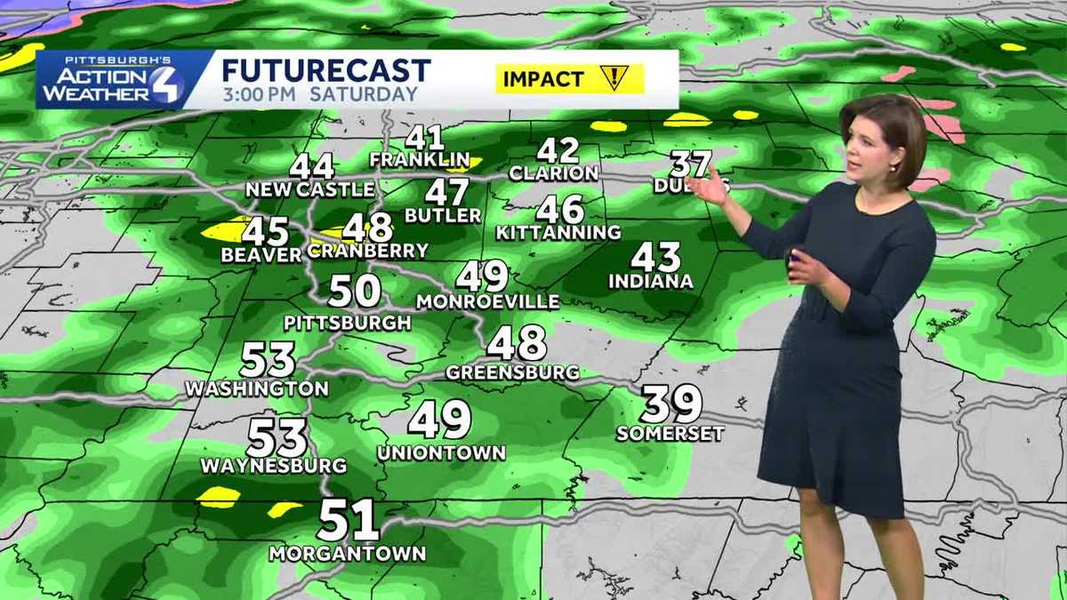
Impact Day: Rain returns today
Another system, arriving from the south, sends more rain our way today. The rain moves in after 9 a.m. There will be occasional lulls, but rain showers will continue through this evening. A few pockets of heavy rain are possible. With more rain and thicker clouds, temperatures will struggle to reach 50 degrees.

Hearst OwnedHearst
Rain moves in from the south after 9 a.m. Periods of rain will continue into this evening.
Sunday’s Impact Day: A return to January
The set up for the end of the weekend certainly says January with colder air, gusty winds, and bursts of snow. Our high temperature on Sunday will happen at midnight with temperatures falling through the day. Factoring in the wind, it will feel like the teens throughout the afternoon. Winds will gust between 25 and 40 mph.

Hearst OwnedHearst
Very light accumulations Sunday, but visibility will be more problematic has the wind picks up.
Scattered flurries and snow showers will across the Pittsburgh area with little accumulation. Visibility will be more problematic as the gusty winds blow the light snow around. Steadier snow showers are possible north of I-80 and in the Laurel Highlands due to lake enhancement.
Chilly for the Steelers Wild Card Game
Dry all day long for our Steelers Monday. The seasonal temperatures will be around as the Steelers host the Texans. Skies will be mainly clear with temperatures in the low 30s for the game.

Hearst OwnedHearst
Chilly and dry for our Steelers Monday. Temperatures will be in the lower 30s for the Wild Card match up.
Temperatures will stay chilly next week. We are watching a system that may involve rain and/or snow for western Pennsylvania on Wednesday.

Hearst OwnedHearst
We are settling back into a January-like pattern next week.
TODAY – Impact Day: Rain showers after 9 a.m. Breezy and mild, high: 51°.
TONIGHT: Rain ends, turning colder with a few late-night snow showers. Low: 33°.
SUNDAY – Impact Day: Temperatures continue to drop after a midnight high in the mid 30s. Feeling like the teens with gusty winds. Scattered light snow.
MONDAY: Partly cloudy and chilly. High: 36°, low: 28°.