
Mild Wednesday With Rain Developing; Light Snow Late In South Central Pennsylvania
Overnight temperatures will be very mild with lows around 40
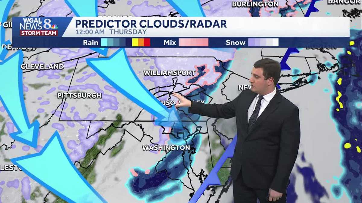
BREAKDOWN OF THOSE CUTS. THAT’S ON NEWS EIGHT AT FIVE. NOW, THE NEWS EIGHT STORM TEAM FORECAST WITH METEOROLOGIST MIKE SUSKO. GOOD TUESDAY EVENING. HOPEFULLY YOU HAD A NICE DAY. WE’LL ENJOY THAT SUNSHINE THAT WAS OUT THERE BECAUSE THE CLOUDS HAVE RETURNED TO THE SUSQUEHANNA VALLEY. LOOKING OUTSIDE LANCASTER RIGHT NOW, 45 DEGREES, IT’S ABOVE AVERAGE FOR THIS TIME OF YEAR. KEEP IN MIND WE SHOULD BE AROUND 38, SO WE ARE MUCH WARMER THAN WE SHOULD BE. ALTHOUGH THAT WIND OUT OF THE SOUTH AT 14MPH IS MAKING IT FEEL MORE LIKE THE UPPER 30S HERE. CURRENT TEMPERATURES IN THE SUSQUEHANNA VALLEY. 47 IN HARRISBURG IT’S 49 IN HERSHEY, AS WELL AS CAMP HILL, CHAMBERSBURG SITTING COMFORTABLY AT 50. SAME THING IN GETTYSBURG AND MIFFLINTOWN. YOU’RE SITTING AT 47 RIGHT NOW. HERE’S A LOOK AT WHAT STORM TEAM LIVE RADAR NETWORK. THERE’S A FEW RETURNS ON THE RADAR POPPING UP, BUT NOTHING IS ACTUALLY REACHING THE GROUND. THAT’S THAT VIRGA THAT WE ALWAYS TALK ABOUT, THAT PRECIPITATION THAT FALLS FROM THE CLOUDS BUT DOESN’T REACH THE GROUND. SO THAT’S WHY SOMETIMES WE SEE STUFF ON RADAR, BUT IT’S NOT ACTUALLY HAPPENING WHERE IT IS SNOWING AND RAINING THOUGH, IS A LITTLE BIT FARTHER TO THE NORTHWEST AND NORTHWEST PENNSYLVANIA. BUT THAT WILL STAY THERE AS WE GO THROUGH THE NIGHT TONIGHT. SO IT’S CLOUDY. TEMPERATURES WILL SLOWLY DROP INTO THE LOW 40S AS WE HEAD TOWARDS THE EVENING AND OVERNIGHT. TONIGHT, IT’S ACTUALLY GOING TO BE QUITE WARM. TEMPERATURES WILL BE IN THE UPPER 30S LOW 40S, WHICH IS CLOSE TO 15 TO 20 DEGREES ABOVE WHERE WE SHOULD BE FOR THE OVERNIGHT LOWS. SO IT’S VERY MILD AS WE GO INTO TOMORROW MORNING. TOMORROW CLOUDY WITH LIGHT RAIN DEVELOPING AND THEN A BRIEF PERIOD OF LIGHT SNOW. NO SNOW LATE AS WE GO INTO TOMORROW EVENING. TOMORROW NIGHT HIGHS WILL BE IN THE UPPER 40S. THAT’S IMPORTANT BECAUSE IT’S NOT GOING TO ALLOW ANYTHING REALLY TO STICK HERE AS WE GO INTO TOMORROW. SO LET’S TIME THIS OUT FOR YOU. WE GOT THE CLOUDS IN PLACE. THEY STICK AROUND AS WE GO THROUGH THE NIGHT. TONIGHT, AS WE HEAD INTO TOMORROW, MAYBE A BRIEF SHOWER AROUND 8:00 AT TIMES, BUT IN THE MORNING THERE. BUT OTHERWISE WE’LL WAIT TILL THE AFTERNOON FOR MOST OF THIS TO GET GOING. AND WE’LL START IN OUR NORTHWESTERN COMMUNITIES FIRST AND THEN EXPAND EAST. SO LANCASTER, YORK COUNTY, LEBANON COUNTY MIGHT TAKE A LITTLE BIT FOR THAT RAIN TO DEVELOP FOR YOU AS THIS COLD FRONT COMES IN DURING THE AFTERNOON AND EVENING HOURS FOR SUSQUEHANNA VALLEY. NOTICE HOW IT IS FILLING IN HERE AROUND SEVEN 8:00 TOMORROW NIGHT. THAT’S WHERE WE’LL SEE THAT MORE STEADY RAIN BEHIND THAT COLD FRONT IS WHEN WE GET THAT TRANSITION OVER TO SNOW FOR A FEW HOURS, AND IT’S EXPECTED TO BE LIGHT IN INTENSITY. SO WE’RE NOT ANTICIPATING A LOT OF ACCUMULATION WITH THIS. AND PLUS, BECAUSE IT’S BEEN SO WARM TODAY AND WILL BE TOMORROW AS WELL, THE GROUND’S JUST NOT GOING TO BE ABLE TO HOLD THAT SNOW. IT’S GOING TO MELT ON CONTACT HERE AS IT COMES ON DOWN. MOST OF THIS IS GONE BY TWO 3:00 IN THE MORNING. SO AS EVEN THOUGH TEMPERATURES ON THURSDAY ACTUALLY WILL BE DROPPING FOR MOST OF THE DAY, IT WILL BE BREEZY AS WELL. WE DON’T ANTICIPATE ANY ISSUES IN TERMS OF SNOWFALL. NOW HERE’S A LOOK AT THE PRECIPITATION CHANCES. IT IS HIGHER THE FARTHER NORTHWEST YOU GO. I WOULD SAY 81 IS KIND OF THE CUTOFF THERE. SO NORTHWEST OF 81 HAS THE BEST CHANCE OF GETTING SOME PERIODS OF RAIN. OTHERWISE YOU’RE LOOKING AT LATER CHANCES FOR THAT RAIN AS WE GO INTO SOUTHEAST OF 81. SO AGAIN, GETTYSBURG, YORK, LANCASTER, LEBANON AREA. THAT IS WHERE WE ANTICIPATE THINGS BEING A LITTLE BIT LATER FOR YOU. HOW MUCH SNOW, IF WE GET IT AT ALL. YOU’RE TALKING AT 10 TO 2 TENTHS OF AN INCH ON GRASSY SURFACES, SO IT’S NOT GOING TO AMOUNT TO MUCH WITH THIS BEHIND THAT FRONT. IT DOES GET WINDY THOUGH. WE’LL SEE THOSE GUSTS INCREASE AS WE HEAD INTO THURSDAY AND FRIDAY. AND THAT’S GOING TO LEAD TO WIND CHILLS IN THE UPPER TEENS AND 20S NOT JUST THURSDAY BUT ALSO FRIDAY. SO A VERY COLD INTO THE WEEK. HERE’S A LOOK AT THE TEN DAY FORECAST. WE’RE LOOKING AT 48 DEGREES FOR THE HIGH TOMORROW 30 ON THURSDAY, 32 FOR YOUR FRIDAY, 38 BY SATURDAY. AND THEN
Mild Wednesday With Rain Developing; Light Snow Late In South Central Pennsylvania
Overnight temperatures will be very mild with lows around 40

Updated: 4:50 PM EST Jan 13, 2026
The clouds have returned to the Susquehanna Valley before rain showers arrive on Wednesday. For tonight, expect the cloudy skies to stick around and milder temperatures in the upper 30s. A stray shower or two is possible, especially towards sunrise. Wednesday will feature cloudy skies, with light rain developing ahead of a cold front. Highs will remain mild, around 48 degrees. As the cold front passes Wednesday night, rain may switch to a brief period of light snow or snow showers, with little to no accumulation expected.After several days in the 40s, highs will fall to 30 degrees on Thursday. A few afternoon snow showers are possible. The bigger story is the wind, which will increase to 15-25 mph, with gusts to 35 mph. This will make it feel like the upper teens to 20 degrees.Blustery and cold conditions continue Friday, as highs hover in the low 30s. The blustery wind will make it feel like the teens & low 20s.We’re watching a clipper that could bring a few snow showers Saturday through early Sunday. Then, blustery and colder weather is in store for Martin Luther King Jr. Day, with highs only reaching the upper 20s. Lows will fall to the teens. Wind chill values will be much lower with single-digit and sub-zero values likely early next week.Tuesday and Wednesday of next week look frigid across the Susquehanna Valley with wind chill values in the single-digits and sub-zero.
The clouds have returned to the Susquehanna Valley before rain showers arrive on Wednesday. For tonight, expect the cloudy skies to stick around and milder temperatures in the upper 30s. A stray shower or two is possible, especially towards sunrise.
Wednesday will feature cloudy skies, with light rain developing ahead of a cold front. Highs will remain mild, around 48 degrees. As the cold front passes Wednesday night, rain may switch to a brief period of light snow or snow showers, with little to no accumulation expected.
After several days in the 40s, highs will fall to 30 degrees on Thursday. A few afternoon snow showers are possible. The bigger story is the wind, which will increase to 15-25 mph, with gusts to 35 mph. This will make it feel like the upper teens to 20 degrees.
Blustery and cold conditions continue Friday, as highs hover in the low 30s. The blustery wind will make it feel like the teens & low 20s.
We’re watching a clipper that could bring a few snow showers Saturday through early Sunday. Then, blustery and colder weather is in store for Martin Luther King Jr. Day, with highs only reaching the upper 20s. Lows will fall to the teens. Wind chill values will be much lower with single-digit and sub-zero values likely early next week.
Tuesday and Wednesday of next week look frigid across the Susquehanna Valley with wind chill values in the single-digits and sub-zero.