

When contemplating places in the United States that are most heavily impacted by snow, as one frequently does, it may seem counterintuitive that the Lehigh Valley would rank higher than a place — any place — in North Dakota. But a new list published recently by lawnlove.com claims it to be so. Furthermore, a ranking of more than 200 snowy counties pegs Lehigh as the fourth most-impacted place in Pennsylvania overall, after Erie, Luzerne and Allegheny.
The lawn service company’s rankings take into account historical snow totals, winter climate (number of days below freezing), and snow removal preparedness. The searchable and sortable rankings are listed below.
While three-quarters of a county’s score is determined by weather, the ranking also factors snow removal preparedness as one-quarter of a county’s score, indicating the effect that a snow storm has on daily life. Lehigh County ranks 60 for snowfall, 104 for climate and 72 for preparedness, which combines for an overall ranking of 73.
That puts Lehigh just outside the top third of the 213 snowiest counties listed out of about 3,200 total counties (and equivalents) nationwide. Lehigh’s overall score was 25.2, compared with 68.7 for top-ranked Coos County, New Hampshire, and 1.02 for last-place Miami-Dade County, Florida.
A look at Pennsylvania counties
The Morning Call looked at data from the National Weather Service to dig a little deeper into the counties listed in Pennsylvania. We included records from 1940 to present, since that is the period with the fewest missing data points in the state’s records.
First, we looked at average seasonal snowfall. The snow season runs from July 1 through June 30.
A keen observer might notice that one place stands out from all the others in Pennsylvania: Erie County, the only one of the state’s 67 counties to border a Great Lake, typically gets bombarded by lake effect snow early in the season.
World Atlas reports that Lake Erie is unique in that it is, by far, the shallowest of the five Great Lakes, averaging only about 62 feet deep, with a maximum depth of 210 feet. (By comparison, Lake Superior averages 483 feet, with a maximum depth of more than 1,300 feet.) As a consequence, the water in Lake Erie warms more, hitting close to 80 degrees in August, and remains warmer than the other lakes into the beginning of winter.
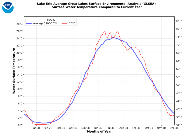
NOAA
This graph from the National Oceanic and Atmospheric Administration, shows the average surface temperature of Lake Erie since 1995.
That warmer water feeds lake effect and lake-enhanced snowfalls early in the season. The University of Michigan’s Great Lakes Integrated Sciences and Assessments Center, funded by the National Oceanic and Atmospheric Administration, says the amount of snow is amplified even more due to the orientation of Lake Erie, which coincides with prevailing winds, making the lake’s “fetch” that much stronger. The National Weather Service uses the term to describe the length that an unobstructed wind can blow over a body of water, picking up moisture and churning waves.
But Lake Erie’s relative shallowness also causes it to cool more than the others later in the winter. It is the only Great Lake capable of being completely frozen over. The colder the water gets, and the larger the ice coverage, the less moisture is available to turbocharge storms later in the season.
Lehigh County has no major bodies of water from which to fetch moisture, nor significant elevation to enhance snowfall. In fact, Blue Mountain and South Mountain partially shield the Valley from the worst of some storms, providing orographic lift, the phenomenon that causes moisture to be squeezed out of storms on the windward sides of mountains, leaving less moisture available on the leeward side.
The combination graph below shows year-by-year snowfall totals for the six counties. Hover over a year to see the totals for all counties.
Next we looked at average temperatures by month. The Weather Service classifies meteorological winter as December through February, so we got the records for the six counties for each winter month. Dauphin County, seat of the state capital in Harrisburg, has the highest average temperature for every month, and Lehigh hovers in the middle.
Erie, once again affected by the eponymous lake, starts off with the same temperature average as Lehigh, but its February average is almost three degrees lower, making it the coldest county of the six in the survey. Lehigh remains middling throughout the winter.
A dry January?
The National Weather Service predicts snow Thursday, but less than half an inch. The Lehigh Valley has gotten only a third of an inch of measurable snow in January, with trace amounts falling on Jan. 2 and 11. Our normal snowfall for this time of year is 2.9 inches, almost 10 times more than we’ve gotten. The total precipitation so far this year is 0.56 inches, less than half the normal amount of 1.27, according to the weather service.