
Western PA: Falling into a cooler and breezy week
A fall-like week with cooler temperatures, occasional gusts, and variable clouds.
CITY, BUT WE’LL HAVE SOME SUNSHINE AND BREEZY CONDITIONS THIS AFTERNOON. TEMPERATURES ARE GOING TO STAY COOLER, UPPER 50S AND LOW 60S. IT’S GOING TO BE A COOL WEEK AHEAD FOR US. WE’LL HAVE A FEW SHOWERS ON TUESDAY. DOESN’T LOOK LIKE A WHOLE LOT. MOST OF IT WILL BE LATE MORNING UNTIL ABOUT LUNCHTIME, AND THEN MUCH COOLER AND BREEZY FOR US ON WEDNESDAY. SMALL CHANCE FOR A STRAY SHOWER AS WELL, BUT NOTHING TOO SIGNIFICANT. YOU CAN SEE A LOT OF THE RAIN IS EAST OF ALLEGHENY COUNTY, BUT IT’S STILL REALLY PACKING A PUNCH HERE INTO WESTMORELAND COUNTY. IF YOU’RE TRAVELING IN THE LIGONIER ALONG ROUTE 30, LATROBE BOROUGH EVEN ALONG 119 SALEM AREA, YOU’RE GOING TO HIT SOME POCKETS OF HEAVY RAIN. THIS IS CONTINUING TO PUSH INTO PORTIONS OF SOMERSET AND EVEN INTO CAMBRIA COUNTY. A LOT OF IT’S STARTING TO EXIT OUT OF FAYETTE COUNTY, BUT SEVEN SPRINGS, EVEN INTO SOMERSET ALONG INTERSTATE 70, SEEING SOME STILL SOME OF THAT HEAVIER RAINFALL NORTH OF 422 INTO NORTHERN PORTIONS OF BUTLER, STILL SEEING SOME RAIN SHOWERS. IT’S EXTENDING INTO ARMSTRONG AND INDIANA COUNTY A LITTLE BIT LINGERING INTO CLARION AS WELL. THIS MORNING, 47 DEGREES AS YOU WAKE UP IN PITTSBURGH, CRANBERRY AND WASHINGTON, GREENSBURG, YOU’RE AT 4846 RIGHT NOW INTO BUTLER AND FRANKLIN, 48 IN BEAVER AND 46 INTO INDIANA. WINDS CONTINUE TO GUST NEAR TEN TO ALMOST 30MPH. AGAIN, WE WILL HAVE GUSTS UP TO 25MPH THROUGHOUT THE DAY. SO IT IS GOING TO KEEP THAT CHILL TO THE AIR. IT IS A COLD RAIN OUTSIDE THIS MORNING. ROADWAYS WILL BE WET. THERE’S LOTS OF LEAVES ON THE ROADS AS WELL THAT CAN MAKE THINGS A LITTLE SLICK FOR YOU. AGAIN, A FEW SHOWERS ON TUESDAY LOOKS TO BE LATE MORNING. WE WILL NOTICE PRETTY QUIET CONDITIONS FOR THE MORNING COMMUTE. GETTING INTO WEDNESDAY IS GOING TO BE BREEZY BUT MUCH COOLER. LOOK AT THOSE HIGHS ONLY REACHING THE MID 50S FOR WEDNESDAY AND THURSDAY. SO A LOOK AT FUTURECAST. WE’RE GOING TO CONTINUE TO SEE THIS RAIN MOVE OUT. STILL AROUND LUNCHTIME. WE’LL HAVE SOME OF THESE STUBBORN CLOUDS LINGERING. BUT GRADUALLY AFTER ONE 2:00 THESE CLOUDS MOVE OUT. WE ARE GOING TO FINISH OUT THE DAY WITH PLENTY OF SUNSHINE. VERY NICE OVERNIGHT. MOSTLY CLEAR TO START. LOOKS GREAT AS WE KICK OFF OUR MORNING COMMUTE. THEN WE’LL START TO SEE THAT EDGE OF THOSE CLOUDS STARTING TO WORK THEIR WAY IN. LOOKS LIKE WE COULD START TO SEE SOME SHOWERS BY LATE MORNING. WE’RE GETTING AROUND TEN 11:00. IT’S IN AND OUT PRETTY QUICKLY. THINGS QUIET DOWN. WE STILL COULD SEE THAT FRONT PASSING THOUGH. AROUND SIX 7:00 WITH SOME POCKETS OF STEADIER RAINFALL FROM ALLEGHENY COUNTY ON NORTH. VERY, VERY ISOLATED. THEN, AS WE HEAD INTO THE OVERNIGHT EARLY WEDNESDAY MORNING, A PASSING SHOWER. WHILE A LOT OF YOU ARE SLEEPING, BUT WE’RE JUST REALLY GOING TO NOTICE THE BREEZY CONDITIONS IN THE COLD AIR, SETTLING IN FOR MID WEEK IS GOING TO BE A BIT ON THE GLOOMY SIDE. WE’LL HAVE THAT CLOUD COVER LINGERING FOR WEDNESDAY. SO AS WE LOOK AT YOUR FOUR DAY PLUS FOUR MORE FORECAST, THE COOLER AIR COMES IN. IT SETTLES IN FOR THE WEEKEND. NICE THING IS WE ARE STAYING DRY FOR FOOTBALL WEEKEND HERE AT HOME. PITT PLAYS ON SATURDAY, STEELERS ON SUNDAY. SO EITHER GAME YOU’RE HEADING TO
Western PA: Falling into a cooler and breezy week
A fall-like week with cooler temperatures, occasional gusts, and variable clouds.

Updated: 5:40 AM EDT Oct 20, 2025
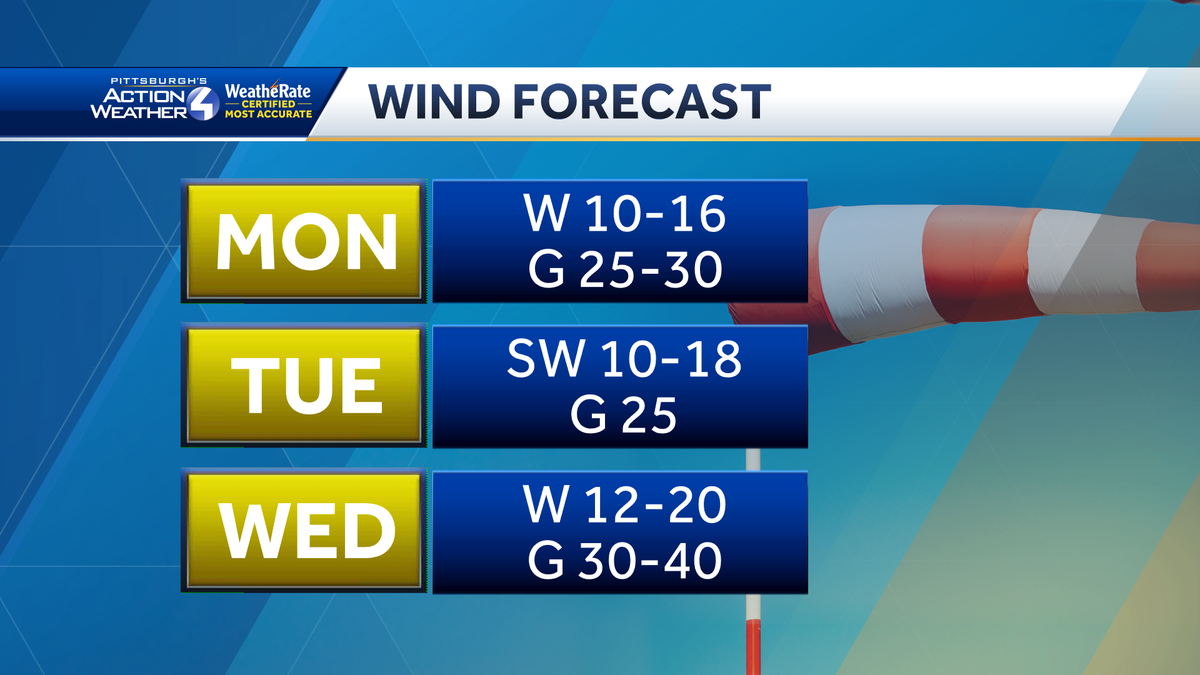
The last of the rain is moving out early this morning. Cooler and drier air sweeps in behind the cold front. This week will stay breezy with gusts between 25 and 30 mph.Drying out after the rainThe rain won’t be an issue for your morning commute. However, wet leaves and other debris could make roads and sidewalks a little slick this morning.Clouds will slowly clear throughout the day. It will be much cooler than the weekend with highs only around 60 degrees. It will be breezy too with gusts around 25 mph.More wind and showers TuesdayAnother front will push waves of widely scattered showers through western Pennsylvania tomorrow. The first batch of light rain will arrive on the tail end of the morning commute before exiting around lunchtime. A few more gusty showers will pop up closer to dinnertime. Wind gusts could peak around 30 mph Tuesday afternoon. This system will draw in even cooler conditions for the middle of the week.Brisk, November-like feeling through late weekThe next cool down will push temperatures down into the mid 50s for the second half of the week. It will be blustery too with even stronger wind gusts up to 40 mph. Outside of a stray shower on Wednesday, especially closer to I-80. The rest of the Pittsburgh area will settle into another dry spell through the weekend. We will enjoy a daily mix of sun and clouds. Temperatures will slowly bounce back into the 60s over the weekend. The forecast looks great for football on the North Shore!TODAY: Morning clouds, afternoon sunshine. Cooler and breezy, gusts around 25 mph. High: 60°.TONIGHT: Clear, a few clouds by sunrise. Low: 43°.TUESDAY: Breezy with off and on spotty showers. High: 62°, low: 42°.WEDNESDAY: Blustery with gusts up to 30 mph. Mostly cloudy with stray shower north. High: 54°, low: 39°.
PITTSBURGH —
The last of the rain is moving out early this morning. Cooler and drier air sweeps in behind the cold front. This week will stay breezy with gusts between 25 and 30 mph.
Drying out after the rain
The rain won’t be an issue for your morning commute. However, wet leaves and other debris could make roads and sidewalks a little slick this morning.

Hearst OwnedHearst
The rain is finally moving out. Be mindful of wet leaves and other debris on the roads and sidewalks this morning.
Clouds will slowly clear throughout the day. It will be much cooler than the weekend with highs only around 60 degrees. It will be breezy too with gusts around 25 mph.

Hearst OwnedHearst
A windy week with occasional gusts between 25 and 40 mph around the Pittsburgh area.
More wind and showers Tuesday
Another front will push waves of widely scattered showers through western Pennsylvania tomorrow. The first batch of light rain will arrive on the tail end of the morning commute before exiting around lunchtime. A few more gusty showers will pop up closer to dinnertime. Wind gusts could peak around 30 mph Tuesday afternoon. This system will draw in even cooler conditions for the middle of the week.

Hearst OwnedHearst
Two batches of showers Tuesday: the first arrives after the morning commute through lunchtime, a second during the evening drive with gusty winds.
Brisk, November-like feeling through late week
The next cool down will push temperatures down into the mid 50s for the second half of the week. It will be blustery too with even stronger wind gusts up to 40 mph. Outside of a stray shower on Wednesday, especially closer to I-80. The rest of the Pittsburgh area will settle into another dry spell through the weekend. We will enjoy a daily mix of sun and clouds. Temperatures will slowly bounce back into the 60s over the weekend. The forecast looks great for football on the North Shore!

Hearst OwnedHearst
Drying out and remaining seasonably cool through the upcoming weekend.
TODAY: Morning clouds, afternoon sunshine. Cooler and breezy, gusts around 25 mph. High: 60°.
TONIGHT: Clear, a few clouds by sunrise. Low: 43°.
TUESDAY: Breezy with off and on spotty showers. High: 62°, low: 42°.
WEDNESDAY: Blustery with gusts up to 30 mph. Mostly cloudy with stray shower north. High: 54°, low: 39°.