
The cold returns as we close out the weekend. Frigid air settles in Monday night, prompting a Severe Weather Alert Day on Tuesday.First wave of cold Sunday and Monday Cold air spills into the area for Sunday and Monday as highs stay in the teens. Some light snow showers will cross the area on Monday that may drop another half an inch to inch of snow. The wind will pick up late Monday as wind chills drop into the single digits during the day and subzero at night.Frigid air and brutal wind chills Tuesday – Alert DayTemperatures will keep dropping Monday night as we wake up around 4° Tuesday morning. Highs will struggle back to the teens, but it won’t feel like that at any point in the day. With winds gusting to 30 mph, wind chills will stay subzero through the day. Tuesday is a Severe Weather Alert Day as wind chills will likely reach 10 below zero and stay subzero through the day. Wind chills could be as cold as 30 below zero in the Laurel Highlands.Improving temperatures late weekTemperatures will improve as we head through the end of next week. Highs will climb above freezing as early as Wednesday. We are watching the potential for a little more snow Wednesday and Thursday. We drop temperatures again heading into next weekend.TONIGHT: Partly to mostly cloudy and cold. Low: 17°.SUNDAY: Colder with mostly cloudy skies. High: 24°, low: 16°.MLK DAY: A few snow showers. Mostly cloudy and windy. High: 23°, low: 4°.TUESDAY: Severe Weather Alert Day. Morning wind chills as low as -10° to -30°. Sub-zero feels continue through the afternoon. High: 16°, low: 8°.
PITTSBURGH —
The cold returns as we close out the weekend. Frigid air settles in Monday night, prompting a Severe Weather Alert Day on Tuesday.
First wave of cold Sunday and Monday
Cold air spills into the area for Sunday and Monday as highs stay in the teens. Some light snow showers will cross the area on Monday that may drop another half an inch to inch of snow. The wind will pick up late Monday as wind chills drop into the single digits during the day and subzero at night.
Frigid air and brutal wind chills Tuesday – Alert Day
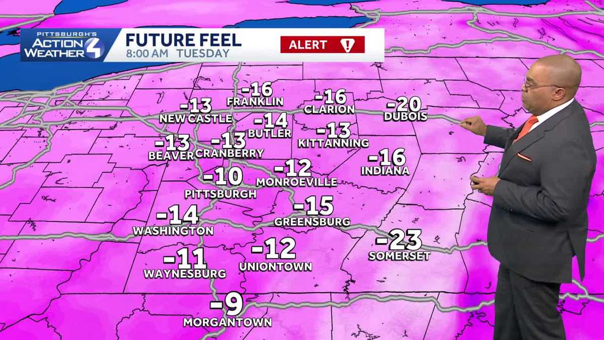
Temperatures will keep dropping Monday night as we wake up around 4° Tuesday morning. Highs will struggle back to the teens, but it won’t feel like that at any point in the day. With winds gusting to 30 mph, wind chills will stay subzero through the day.

Hearst Owned
Wind chills Tuesday morning could be as cold as -30.
Tuesday is a Severe Weather Alert Day as wind chills will likely reach 10 below zero and stay subzero through the day. Wind chills could be as cold as 30 below zero in the Laurel Highlands.
Improving temperatures late week
Temperatures will improve as we head through the end of next week. Highs will climb above freezing as early as Wednesday. We are watching the potential for a little more snow Wednesday and Thursday. We drop temperatures again heading into next weekend.

Hearst Owned
Cold air arrives to finish the weekend with dangerous cold on Tuesday.
TONIGHT: Partly to mostly cloudy and cold. Low: 17°.
SUNDAY: Colder with mostly cloudy skies. High: 24°, low: 16°.
MLK DAY: A few snow showers. Mostly cloudy and windy. High: 23°, low: 4°.
TUESDAY: Severe Weather Alert Day. Morning wind chills as low as -10° to -30°. Sub-zero feels continue through the afternoon. High: 16°, low: 8°.