
Is a winter storm headed our way this weekend?
NOW, THE WGAL NEWS EIGHT STORM TEAM FORECAST, WITH METEOROLOGIST MIKE SUSKO. GOOD AFTERNOON. THE SUN IS SHINING IN PARTS OF THE AREA THAT’S HELPING TO WARM UP SOME OF THE ROADS AND MELT ANYTHING THAT’S LEFT OVER FROM THE WEEKEND. BUT TONIGHT WE’LL BE TRACKING SUBZERO WIND CHILLS AS WE GO INTO TUESDAY MORNING, AND THEN ONLY SINGLE DIGIT WIND CHILLS FOR MOST OF THE DAY TOMORROW. AND IF YOU ARE HOPING FOR SOME WARMER WEATHER, THE GOOD NEWS IS WE GET TO AT LEAST 40 DEGREES ON THURSDAY. IT’S SHORT LIVED, THOUGH, BECAUSE ANOTHER ARCTIC AIR MASS COMES IN NEXT WEEKEND AND STICKS AROUND INTO NEXT WEEK, SO WE ARE DEFINITELY IN THE THICK OF THE WINTER CHILL ACROSS THE SUSQUEHANNA VALLEY, INCLUDING IN YORK. RIGHT NOW. WE’VE GOT THAT MIX OF SUN AND CLOUDS. IT’S DRY. IT’S JUST COLD, 31 DEGREES WITH WINDS OUT OF THE WEST AROUND 16MPH, MAKING IT FEEL MORE LIKE 20. WE’RE GOING TO BE WATCHING THAT WIND CHILL CLOSELY OVER THE NEXT 24 HOURS OR SO HERE ACROSS THE AREA RIGHT NOW. STORM TEAM LIVE RADAR SHOWING A MIX OF SUN AND CLOUDS TO THE NORTHWEST. WE HAVE SOME SNOW SQUALLS. ACTUALLY, THOSE PINK BOXES YOU SEE ARE SNOW SQUALL WARNINGS ACROSS PARTS OF WESTERN PENNSYLVANIA. JUST BE AWARE OF THAT IF YOU ARE HEADING ALONG I-80, ESPECIALLY WEST THIS AFTERNOON, YOU MAY ENCOUNTER SOME OF THAT, BUT I THINK THIS ENDS UP MISSING US JUST TO THE NORTH AND WEST AS WE GO THROUGH THE AFTERNOON. MAKE IT A NICE LATE FLURRY IN MIFFLIN AND JUNIATA COUNTY, BUT THAT’S PRETTY MUCH IT FOR THE REST OF THE DAY. PARTLY CLOUDY. HIGHS THEMSELVES RIGHT AROUND 32 DEGREES, BUT IT’S GOING TO FEEL MORE LIKE THE 20S AS WE GO THROUGH THE AFTERNOON. TONIGHT. IT’S GOING TO FEEL LIKE WE’RE BELOW ZERO. OVERNIGHT LOWS THEMSELVES AROUND TEN DEGREES. BUT THAT WIND OUT OF THE WEST 10 TO 20MPH AND JUST BE ENOUGH WHERE IT FEELS LIKE BELOW ZERO, MAKING TONIGHT AN IMPACT NIGHT AND TOMORROW MOSTLY SUNNY WITH THOSE SINGLE DIGIT WIND CHILLS CONTINUING THROUGHOUT THE ENTIRE DAY. WIND CHILLS WILL. WE GO INTO TOMORROW EVENING, AND THAT’S GOING TO MAKE A BIG DIFFERENCE FOR TUESDAY NIGHT INTO WEDNESDAY MORNING. BUT HERE’S A LOOK AT THE TEMPERATURE AND WIND CHILL FOR THE WIND CHILLS IN PINK AND YOU CAN SEE THAT MINUS TWO AROUND 8 A.M. AND THEN MAYBE GETTING UP TO TEN DEGREES FOR THE WIND CHILL DURING THE AFTERNOON. SO NO MATTER HOW YOU SLICE IT, IT’S COLD. BASICALLY, YOU’RE JUST TAKING THE NEGATIVE SIGN AND SWITCHING IT TO A POSITIVE THROUGHOUT THE DAY AS WE GO INTO YOUR TUESDAY. SO JUST MAKE SURE YOU BUNDLE UP HERE, YOU KNOW, DRESS IN LAYERS, ALL THAT GOOD STUFF TO STAY WARM HERE AS WE GO THROUGH YOUR TUESDAY. AND LIKE I SAID THOSE WINDS DO CALM DOWN AS WE GO INTO TOMORROW NIGHT. THE CULPRIT? IT’S THIS COLD FRONT. BEHIND IT, WE HAVE FRIGID AIR FROM THE ARCTIC COMING IN, AND THAT’S JUST GOING TO MAKE IT COLD AS WE GO INTO YOUR TUESDAY. BUT IT STAYS DRY FOR THROUGHOUT THE DAY TOMORROW. HIGH PRESSURE HELPS RELAX THOSE WINDS TUESDAY NIGHT INTO WEDNESDAY ITSELF THOUGH, WE WILL BE WATCHING FOR SOME SNOW SHOWERS, MAYBE WEDNESDAY NIGHT INTO THURSDAY AS ANOTHER FRONT WILL APPROACH THE AREA. HIGH TEMPERATURES WILL GET UP TO 40 DEGREES BY THURSDAY ITSELF, BUT THEN THEY DROP AS WE HEAD INTO THE WEEKEND. I ALSO WANT TO MENTION FOR THE WEEKEND SOME MODELS ARE SHOWING THE POTENTIAL FOR A LITTLE BIT OF SNOW. KEEP IN MIND WE ARE STILL 5 TO 6 DAYS OUT HERE, SO A LOT CAN CHANGE AND BE CAREFUL IF YOU SEE ANYTHING ONLINE WITH HIGH SNOW TOTALS THIS FAR OUT BECAUSE 50 MILES OR MORE IT CAN STILL MAKE A BIG DIFFERENCE. SO JUST BE AWARE OF THAT FOR THE WEEKEND. IF YOU HAPPEN TO SEE ANYTHING ONLINE. HERE’S A LOOK AT THE TEN DAY FORECAST. 32 DEGREES WILL BE THE HIGH ON TODAY 22 TOMORROW. WITH THOSE SUBZERO WIND CHILLS IN THE MORNING, 34 ON WEDNESDAY, 40 ON THURSDAY, AND THEN ARCTIC
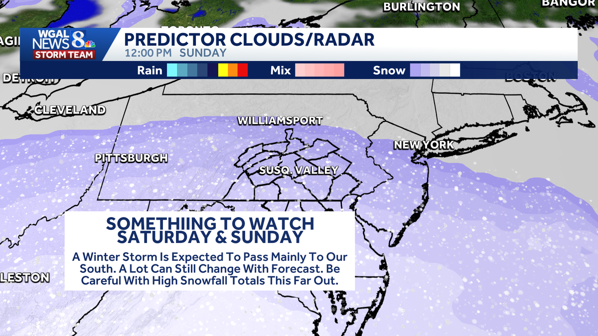
There has been a lot of buzz around social media regarding a possible big snowstorm this upcoming weekend in parts of the Mid-Atlantic. While a storm system is likely to impact areas of North Carolina, South Carolina, and Virginia, the northern extent is still uncertain.Be careful with high snow totals this far outWe are aware that some models and weather apps are giving very high snowfall amounts for the weekend. Keep in mind, we are still five to seven days out from the event. In addition to the actual storm track and timing, there is still a lot of uncertainty with how a very strong area of high pressure will interact with it.A stronger high or more southerly position will likely keep the storm farther south. However, a weaker high or more northerly position can help the snow move farther north. At this point, just be aware that there is a chance for a winter storm over the weekend in the region. We will continue to monitor the forecast and let you know if and when it is something you need to be concerned about.
There has been a lot of buzz around social media regarding a possible big snowstorm this upcoming weekend in parts of the Mid-Atlantic. While a storm system is likely to impact areas of North Carolina, South Carolina, and Virginia, the northern extent is still uncertain.
Be careful with high snow totals this far out

We are aware that some models and weather apps are giving very high snowfall amounts for the weekend. Keep in mind, we are still five to seven days out from the event. In addition to the actual storm track and timing, there is still a lot of uncertainty with how a very strong area of high pressure will interact with it.

A stronger high or more southerly position will likely keep the storm farther south. However, a weaker high or more northerly position can help the snow move farther north.
At this point, just be aware that there is a chance for a winter storm over the weekend in the region. We will continue to monitor the forecast and let you know if and when it is something you need to be concerned about.
