
It’s been the subject of online and offline conversations for the past 24 hours, but the first big snowstorm of 2026 is arriving online before it shows up in the official forecast. Reddit threads and weather‑nerd group chats are buzzing about screenshots that show upwards of 15 inches of snow for Sunday in the city, even as forecasters stress that the storm’s exact track — and how hard it hits Philadelphia — is still very much in flux.
Which is all true. But there’s this …
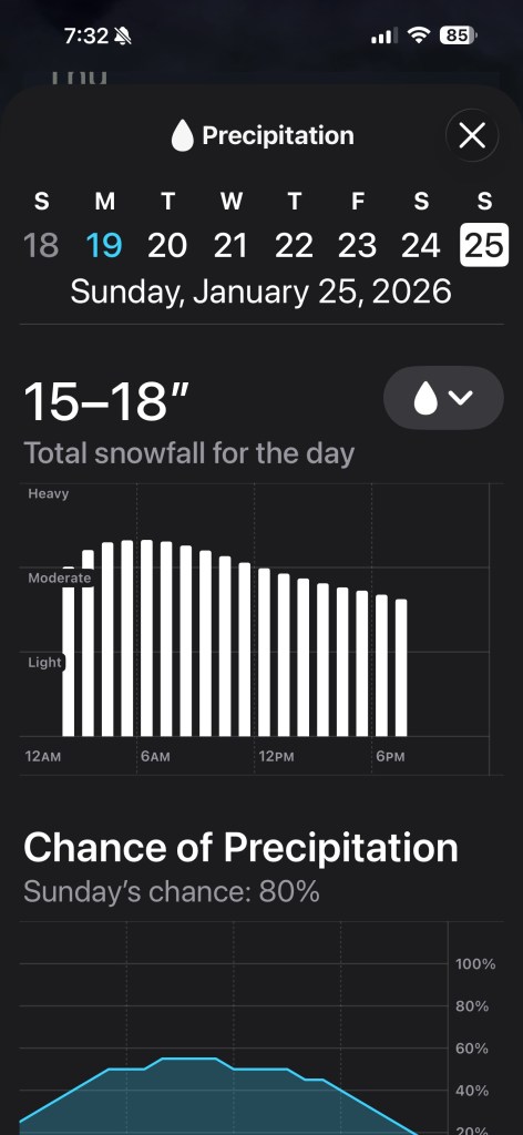 Screenshot
On r/philadelphia, one post with a phone‑screenshot forecast of nearly two feet has become a kind of Rorschach test for winter‑starved locals: some are planning sledding routes and hoagie runs, others are begging everyone to stop jinxing it.
In broader weather subreddits, users — including a few self‑identified folks watching “from Philly” — are trading model images and talking about “finally getting lucky” after a string of near‑miss storms, which only adds to the sense that something big is bearing down on the city. The vibe is familiar: half excitement, half eye‑rolling at how quickly this town can jump from “dusting” to “shut it all down.”
The most likely path for the week, though, looks less like a guaranteed blockbuster and more like a high‑potential setup evolving in slow motion.
Here’s what’s certain: A deep shot of Arctic air is locking in across the East, dropping wind chills into the single digits and teens — Tuesday morning and the next few days — and setting the stage for any late‑week system to fall as snow instead of rain. The National Weather Service in Mount Holly notes an unusually strong signal for a winter storm about five to six days out, with probabilistic guidance showing roughly a 40–60% chance of at least 2 inches and a 20–40% chance of 6 inches or more across areas south of Philadelphia, with lower odds but still notable chances in and around the city itself. In its discussion, the office talks about “high‑end potential” but just as clearly warns that the storm could still shift track and deliver far less, a reminder that the models throwing out foot‑plus totals are only one slice of a wide range.
For Philadelphia, that translates into a week that starts with plain old brutal cold and then gradually raises the stakes. Early on, the city deals with the kind of January weather that makes walking down Market Street feel like navigating a wind tunnel: highs struggling near freezing, lows in the teens, and wind chills that flirt with zero.
As the weekend approaches, attention turns to a developing system riding along the clash zone between that entrenched cold and milder, moisture‑rich air to the south — the classic I‑95 nail‑biter. If the storm tracks close enough to the coast, the city could be looking at a plowable, disruptive snowfall, with heavier bands possible if the low strengthens just offshore; if it slides farther south or east, the real “wow” totals could end up in South Jersey, Delaware, or points south, leaving Philly with something more modest.
As an arctic front crosses our area this evening, a bitterly cold airmass settles in and lasts through Tuesday night. Gusty winds will enhance the cold through Tuesday. Stay warm! And, we continue to monitor a possible winter storm for next weekend. #pawx #njwx #dewx #mdwx pic.twitter.com/qCN6TCQn1H
— NWS Mount Holly (@NWS_MountHolly) January 19, 2026
To provide some context, it’s been a while since Philly dealt with anything this big. The past decade has been relatively quiet after a two-decade stretch that included some of the biggest snowstorms in the city’s history:
The last “big one” was the Blizzard of 2016, with 22.4 inches (ranking fourth all-time).
A significant snow in February 2010, which saw a massive 28.5 inches (second all-time) and a combined 44 inches over a week with another storm.
December 2009, which brought 23.2 inches (third all-time) and was the biggest December storm ever.
The 1996 blizzard (30.7 inches) remains the all-time record.
We’ll keep our eyes on the projections and provide updates as makes sense.