
COUNTIES. LATE. BUT OVERALL, JUST MORE CLOUDS AND MILDER HIGHS. FINALLY, ON THURSDAY, A VERY WEAK BOUNDARY CROSSES IN THE MORNING WITH JUST A SLIM CHANCE OF A SNOW SHOWER. IT DOESN’T DO MUCH TO OUR TEMPERATURES. OUR TEMPERATURES WARM UP ON THURSDAY. WE COULD EASILY HIT 40 DEGREES. NOW FORGET ABOUT THE 40S THIS WEEKEND. WE HAVE A STORM SYSTEM THAT’S GOING TO BE PASSING THROUGH THE SOUTHEAST, THROUGH THE MID-ATLANTIC, AND OUT TO SEA. WE ARE ON THE NORTHERN EDGE OF THAT STORM SYSTEM. SO I THINK REALLY THROUGHOUT THE DAY SUNDAY, WE COULD BE SEEING SOME LIGHT TO MODERATE SNOWFALL. STILL TOO EARLY FOR THE EXACT TRACK. THE TIMING ON THIS, THE TOTALS ON THIS. BUT I COULD SEE A COUPLE OF INCHES OF SNOW FOR SURE ON SUNDAY AS THAT SYSTEM SCOOTS BY TO OUR SOUTH. SO WE’RE GOING TO KEEP YOU UPDATED ON THAT AS IT EVOLVES. UNTIL THEN, WE DO SEE A LITTLE BIT OF A WARM UP THURSDAY INTO FRIDAY THERE EVEN WEDNESDAY NOT TOO BAD. BUT THE ARCTIC AIR SETTLES IN THIS WEEKEND WITH THOSE TEMPERATURES IN THE TEENS TO NEAR 20 DEGREES. NEXT WEEK WE DON’T GET OUT O
Here’s how much snow we could get this weekend | Still too early for exact track, amounts

Updated: 8:52 AM EST Jan 20, 2026
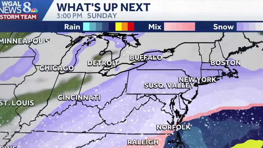
Light to moderate snow is likely Sunday for South-Central Pennsylvania as a big storm tracks just to our south this weekend. However, it’s still too early to determine the exact track and snowfall amounts.”We have a storm system that’s going to be passing through the southeast, through the Mid-Atlantic and out to sea. We are on the northern edge of that storm system. So, I think really throughout the day Sunday, we could be seeing some light to moderate snowfall,” WGAL Chief Meteorologist Christine Ferreira said.Timing of weekend snowExpect light to moderate snowfall late Saturday throughout the day Sunday as the system moves east.Exact timing and peak bands are still uncertain and may shift.Expected totalsA few inches are possible in many areas; isolated spots could get a bit more.Totals will depend on the final track — plan for variable accumulations.Temperatures and Arctic airArctic air settles in this weekend.Highs generally stuck in the 20s this weekend, falling into the teens next week.Overnight lows will range from single digits to the upper teens.Impacts and adviceSlick spots possible on untreated roads and sidewalks — monitor travel conditions.Stay tuned for updates as the track and totals become clearer.SOUTH-CENTRAL PA WEATHER RESOURCES: INTERACTIVE RADAR | ACTIVE WEATHER ALERTS | CURRENT CONDITIONS | HOURLY FORECAST | 10-DAY FORECAST | WEEKEND FORECAST | MAP ROOM | DOWNLOAD THE APP | WEATHER EMAILS
Light to moderate snow is likely Sunday for South-Central Pennsylvania as a big storm tracks just to our south this weekend. However, it’s still too early to determine the exact track and snowfall amounts.
“We have a storm system that’s going to be passing through the southeast, through the Mid-Atlantic and out to sea. We are on the northern edge of that storm system. So, I think really throughout the day Sunday, we could be seeing some light to moderate snowfall,” WGAL Chief Meteorologist Christine Ferreira said.
Timing of weekend snowExpect light to moderate snowfall late Saturday throughout the day Sunday as the system moves east.Exact timing and peak bands are still uncertain and may shift.


Expected totalsA few inches are possible in many areas; isolated spots could get a bit more.Totals will depend on the final track — plan for variable accumulations.


Temperatures and Arctic airArctic air settles in this weekend.Highs generally stuck in the 20s this weekend, falling into the teens next week.Overnight lows will range from single digits to the upper teens.Impacts and adviceSlick spots possible on untreated roads and sidewalks — monitor travel conditions.Stay tuned for updates as the track and totals become clearer.
SOUTH-CENTRAL PA WEATHER RESOURCES: INTERACTIVE RADAR | ACTIVE WEATHER ALERTS | CURRENT CONDITIONS | HOURLY FORECAST | 10-DAY FORECAST | WEEKEND FORECAST | MAP ROOM | DOWNLOAD THE APP | WEATHER EMAILS