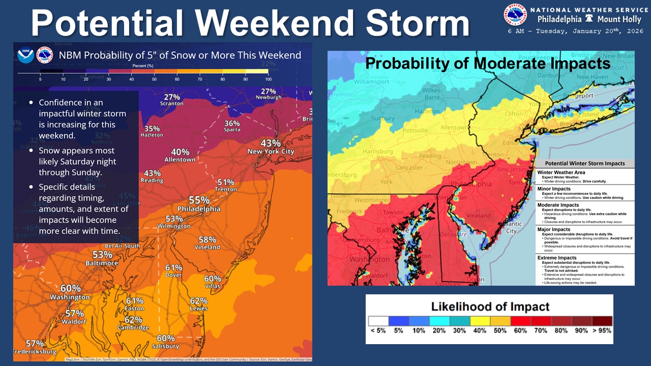
Residents in the Lehigh Valley should prepare for a prolonged arctic blast with dangerously low wind chills and single-digit low temperatures, with an increasing likelihood of a significant winter storm potentially impacting the region late Saturday into Sunday.
Wind chills dropped below zero degrees Tuesday morning in the Lehigh Valley, with actual air temperatures in the single digits. At 6:51 a.m., the National Weather Service reported a temperature of 9 degrees at Lehigh Valley International Airport, with a west wind of 10 mph creating a wind chill of minus 4 degrees.
The National Weather Service has issued a Cold Weather Advisory for the Lehigh Valley and most areas near and northwest of the I-95 corridor, warning residents to take precautions against extreme cold. Wearing multiple layers and limiting outdoor exposure is strongly recommended.
The weather service issued the advisory to expire at 10 a.m. Tuesday but warns air temperatures are forecast to dip back into the single digits overnight into Wednesday morning.
A deep atmospheric trough is ushering in an arctic air mass. Wind chills could reach as low as negative 10 degrees in the southern Poconos and near or below zero in the Lehigh Valley.
Forecasters anticipate another round of frigid temperatures Friday night into the weekend.
Temperatures will briefly moderate to more seasonable levels on Wednesday and Thursday, with highs in the 30s and 40s. However, another arctic front will push through late week, returning temperatures to the 20s and 30s by Friday.
Of particular interest is the potential winter storm developing late Saturday through Sunday. Current forecast models suggest a 60-70% chance of at least two inches of snow, with a 40-60% probability of 6 or more inches for areas along and south of the I-95 corridor. However, meteorologists caution that it is still too early to predict precise snowfall amounts with confidence.
Rounds of snowfall this past Saturday and Sunday dropped 8.7 inches at the weather service’s Lehigh Valley International Airport climate station. That pushed this winter’s total snowfall to 16.7 inches, which is above the normal 10.9 inches for the season to date.
Current weather radar