
Impact Day: Cold temperatures, scattered snow showers in Western Pennsylvania
TALK ABOUT THAT, ESPECIALLY WHEN YOU NEED TO CLEAN YOUR WINDSHIELD AND YOU DON’T WANT TO RISK IT. ABSOLUTELY. AND WE’RE GOING TO SEE MORE OF THOSE COLD BATTERY AND CAR BATTERY ISSUES THIS WEEKEND. WE WILL GET INTO A TEMPORARY THAW LATER TODAY AND TOMORROW. AS WE MAKE THE TRANSITION. THERE WILL BE A FEW SNOW SHOWERS AROUND EARLY THIS AFTERNOON. MINIMAL IF ANY ACCUMULATION LOCALLY NORTH OF I-80, MAYBE AN INCH OR SO. AGAIN, THE THAW THROUGH TOMORROW AND THEN THE NEXT COLD SHOT ARRIVING FRIDAY INTO THE WEEKEND. OUTSIDE. RIGHT NOW IT IS BITTER COLD TEMPERATURES IN THE UPPER SINGLE DIGITS TO LOW TEENS RIGHT NOW, 11 IN PITTSBURGH, AS WELL AS MONROEVILLE AND CRANBERRY. AND THESE NUMBERS WILL CONTINUE TO SURGE INTO THE 30S BY LATER THIS AFTERNOON. THANKFULLY, NOT MUCH OF A WIND, SO NOT MUCH OF A WIND CHILL FACTOR OUTSIDE THIS MORNING. WIND SPEEDS GENERALLY LESS THAN FIVE MILES AN HOUR, SHOULD EVENTUALLY GET TO 36 LATER THIS AFTERNOON. AGAIN, A FEW SNOW SHOWERS AROUND THE MIDDAY TIME FRAME. THAT’S YOUR IMPACT DAY, BUT AGAIN, LITTLE IF ANYTHING WILL STICK LOCALLY. TEMPERATURES IN THE MID 30S TOMORROW STARTS TO TURN COLDER AGAIN ON FRIDAY, AND THE CORE OF THE COLDEST AIR WILL BE OVERHEAD ON SATURDAY, WITH TEMPERATURES ONLY IN THE LOW TO MID TEENS FOR HIGHS, MAKING SATURDAY A SEVERE WEATHER ALERT DAY FOR THE COLD. HERE’S A LOOK AT SATELLITE AND RADAR RIGHT NOW. A FEW FLAKES AND FLURRIES ACROSS PORTIONS OF CENTRAL OHIO. THEY WON’T SHIFT THROUGH OUR AREA UNTIL EARLY THIS AFTERNOON. NOON ONE 2:00. AS WE’LL SEE OUR FLAKES AND FLURRIES FLYING BY THAT POINT, TEMPERATURES WILL PROBABLY BE REACHING THE LOW TO MID 30S. AND IT’S NOT OUT OF THE QUESTION THAT MAYBE SOUTH OF I-70 COULD EVEN BE A FEW RAIN SHOWERS MIXING IN AS THOSE WINDS SHIFT OUT OF THE SOUTHWEST AND PUSH THOSE TEMPERATURES INTO THE MID 30S FOR HIGHS BY LATER THIS AFTERNOON. HERE’S 8:00 THIS MORNING. FINE THROUGH THE MORNING COMMUTE. FAST FORWARD TO NOON, 1:00. HERE’S A WAVE OF FLAKES AND FLURRIES COMING THROUGH AGAIN. WOULDN’T BE SURPRISED TO SEE SOME LIGHT RAIN MIXING IN SOUTH OF I-70, ESPECIALLY AS WE HEAD TOWARD LATE THIS AFTERNOON. EARLY THIS EVENING. STILL PICKING UP MOISTURE AT THAT POINT SHOULD BE WELL ABOVE FREEZING. SO I THINK WHAT YOU’RE SEEING IN FAYETTE COUNTY WILL LIKELY BE A PERIOD OF SOME LINGERING RAIN SHOWERS, WHILE NORTH OF I-80, SOME FLAKES AND FLURRIES WILL CONTINUE TO FLY. AND THEN TOMORROW, OUTSIDE OF A MORNING FLURRY, SHOULD SEE SOME BREAKS OF AFTERNOON SUNSHINE. AGAIN. MINIMAL ACCUMULATION LOCALLY, MAYBE A COATING IN SPOTS AN INCH OR SO WILL BE POSSIBLE NORTH OF I-80. CLARION FRANKLIN ON UP TOWARD TIONESTA MAYBE AN INCH OR TWO BY LATER THIS EVENING. 36 THE HIGH TEMPERATURE TODAY, AN IMPACT DAY FOR THAT PERIOD OF A FEW SNOW SHOWERS EARLY THIS AFTERNOON FOR TOMORROW CONTINUES 34. TURNING COLDER AGAIN ON FRIDAY, 23 DEGREES AND THEN SATURDAY. THE CORE OF THE COLDEST AIR, THE HIGH ONLY 14. AND THAT OPPORTUNITY TO SEE ANOTHER ROUND OF SOME LIGHT SNOW SHOWERS ON SUNDAY. LOOKS LIKE THAT STORM SYSTEM THAT’S BEEN GETTING A LOT OF RUN ON SOCIAL MEDIA IS GOING TO STAY MAINLY TO OUR SOUTH. WE’LL JUST GET LIGHT SNOW SHOWERS LOCALLY. AND WHAT WE’RE PROBABLY LOOKING AT RIGHT NOW, AT LEAST BASED ON CURRENT INFORMATION LATE IN THE WEEKEND, AN INCH, AN INCH AND A HALF MAYBE THROUGHOUT THE DAY ON SUNDAY. SO NOT TERRIBLY IMPACTFUL AS THEY WILL SEE TO AREAS WELL TO OUR SOUTH. WE LIKE TO SAY THIS TIME OF YEAR WE’LL TAKE THE SMALL WINS WHEREVER WE CAN. YES, 36 FEELS LIKE A BIG WIN. YES, ESPECIALLY THIS MORNING. IT’S LIKE 11 DEGREES, 36 BY 4:00. IT’S GOING TO FEEL GREAT, WE’RE GOING TO GET QUITE THE HEAT UP HERE. PITTSBURGH
Impact Day: Cold temperatures, scattered snow showers in Western Pennsylvania

Updated: 11:28 AM EST Jan 21, 2026
The cold air will ease up Wednesday afternoon and the temporary thaw will continue into Thursday before another blast of bitter arctic air arrives Friday and into the weekend.Severe weather alerts: Get FREE alerts to your phone or emailSchool closings/delays: See the listLearn how to enable automatic weather alerts on the WTAE appImpact Day: Snow Wednesday afternoonTemperatures around 10 degrees in the morning will improve with highs above freezing and into the mid 30s in the afternoon.Clouds return ahead of another clipper with scattered snow in the afternoon. There will be little or no accumulation locally, with the best chance to get an inch or two being north of Interstate 80. Flakes will fizzle by Thursday morning.A winter weather advisory has been issued for Clarion, Forest, Indiana and Venango counties from 1 p.m. Wednesday to 10 a.m. Thursday.Temperatures temporarily improveEven though temperatures will improve slightly late week, the brutal cold isn’t done with us. Prolonged frigid air will settle in starting this weekend. This will promote subzero wind chills again on Saturday. Saturday is a Severe Weather Alert Day for wind chills that will be well below zero. We will also watch a storm that takes a southern track over the weekend. More snow is possible on Sunday, prompting an Impact Day for the snow and cold.WEDNESDAY – Impact Day: Frigid morning, seasonal afternoon. Scattered afternoon snow. High: 36°, low: 30°.THURSDAY: Mostly cloudy and chilly. High: 34°, low: 15°.FRIDAY: Mostly cloudy. Cold. High: 24°, low: 4°.
PITTSBURGH —
The cold air will ease up Wednesday afternoon and the temporary thaw will continue into Thursday before another blast of bitter arctic air arrives Friday and into the weekend.

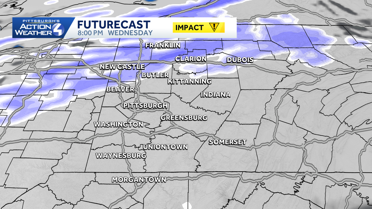
Impact Day: Snow Wednesday afternoon
Temperatures around 10 degrees in the morning will improve with highs above freezing and into the mid 30s in the afternoon.
Clouds return ahead of another clipper with scattered snow in the afternoon. There will be little or no accumulation locally, with the best chance to get an inch or two being north of Interstate 80. Flakes will fizzle by Thursday morning.

A winter weather advisory has been issued for Clarion, Forest, Indiana and Venango counties from 1 p.m. Wednesday to 10 a.m. Thursday.

Temperatures temporarily improve
Even though temperatures will improve slightly late week, the brutal cold isn’t done with us.
Prolonged frigid air will settle in starting this weekend. This will promote subzero wind chills again on Saturday.
Saturday is a Severe Weather Alert Day for wind chills that will be well below zero. We will also watch a storm that takes a southern track over the weekend.
More snow is possible on Sunday, prompting an Impact Day for the snow and cold.

WEDNESDAY – Impact Day: Frigid morning, seasonal afternoon. Scattered afternoon snow. High: 36°, low: 30°.
THURSDAY: Mostly cloudy and chilly. High: 34°, low: 15°.
FRIDAY: Mostly cloudy. Cold. High: 24°, low: 4°.