
Models show snow storm possible Sunday for Pennsylvania | What we know, don’t know right now
ENERGY. SNOW SHOWERS ACROSS WESTERN PENNSYLVANIA FOR US TODAY. THOSE WILL COME TO AN END BY TOMORROW MORNING. AND THEN THE TEMPERATURES START DROPPING. THAT’S THE STORY. BEFORE WE EVEN LOOK TO SUNDAY, AS WE’LL BE DANGEROUS COLD ON SATURDAY, WHICH IS A SEVERE WEATHER ALERT DAY WHERE WIND CHILLS WILL BE SUBZERO, LIKELY FOR A GOOD PORTION OF THE DAY. SO AGAIN, SNOW SHOWERS ARE WORKING THROUGH NOW. MOST OF US SEEING SNOW. THIS IS GENERALLY PRETTY LIGHT. AND AS THE SNOW ARRIVES, MAYBE A QUICK HALF AN INCH OR SO IN SPOTS. IT’S REALLY AS WE GET INTO LATER THIS AFTERNOON AND THIS EVENING THAT WE’LL WATCH FOR THAT SNOW TO REALLY PILE UP EAST AND NORTH OF PITTSBURGH. THAT’S WHERE WE HAVE OUR WINTER WEATHER ADVISORIES IN EFFECT, WHERE THESE SQUALLS WILL KIND OF SET UP INTO THE LAUREL HIGHLANDS. AND THEN A SECOND CLUSTER AS YOU HEAD ALONG AND NORTH OF INTERSTATE 80. WE’RE IN BOTH OF THOSE LOCATIONS, POTENTIALLY 2 TO 4IN OF SNOW IS POSSIBLE AGAIN IN THOSE HEAVIER BURSTS OF SNOW. AGAIN, EVERYBODY ELSE OUTSIDE OF THE LAUREL HIGHLANDS AND SOUTH OF 422 WILL BE LUCKY TO SEE REALLY MORE THAN A HALF AN INCH. WE DRY OUT TOMORROW AT 32. THEN THE TEMPERATURES FALL 22 FOR US ON FRIDAY. WE’LL START AT ONE ON SATURDAY, FINISH AT ONLY 12, BUT WIND CHILLS WILL BE SUBZERO IN THE MORNING. POTENTIALLY COLDER THAN WHAT WE JUST SAW A COUPLE OF DAYS AGO, AND THEY’LL STAY LIKELY SUBZERO AS WE HEAD THROUGH THE DAY. SO ANOTHER DANGEROUSLY COLD DAY FOR US. AND THEN WE’RE WATCHING SUNDAY. THE ONE THING THAT’S CHANGED TODAY IS ALL OF OUR MODELS ARE IN AGREEMENT. THIS COULD POTENTIALLY BE A SIGNIFICANT SNOWFALL EVENT ACROSS WESTERN PENNSYLVANIA, WHERE SNOW COULD START LATE SATURDAY. STAY WITH US THROUGH THE DAY ON SUNDAY. AND A NEW WRINKLE TODAY. WE MAY GET SOME WARMER AIR THAT WORKS IN SOUTH OF PITTSBURGH. THAT COULD CHANGE OVER TO SNOW, TO FREEZING RAIN AND OR RAIN THROUGH THE DAY. SO A LOT OF VARIABLES. WE STILL HAVE TO WORK OUT, BUT THE POTENTIAL FOR A SIGNIFICANT SNOWFALL IS INCREASING. SO WE’RE WATCHING SUNDAY VERY CLOSELY. WE’LL KEEP THE COLD AIR AROUND FOR MONDAY AND TUESDAY. HIGHS IN THE TEENS, LOWS IN THE SINGLE DIGITS. AND THEN ANOTHER SNOW CHANCE GETS TO US AS WE HEAD INTO WEDNESDAY. A COUPLE FLAKES FLYING HERE ON ACTION CAM AS WE LOOK OVER DOWNTOWN. IT IS 33. WE ARE ABOVE FREEZING OFFICIALLY AT THE AIRPORT. WILL ONLY DO THAT ONE MORE DAY. TH
Models show snow storm possible Sunday for Pennsylvania | What we know, don’t know right now

Updated: 12:48 PM EST Jan 21, 2026
As we get closer to the weekend, it appears that snow will fall across Western PA on Sunday. Some questions have been answered today, but there is still plenty that we don’t know as we approach the weekend.What we knowSnow likely starts late Saturday (after dinner) and lasts through the day SundaySnow could be heavy at timesThe heaviest snow is likely overnight Saturday into Sunday morningTravel will be difficult, especially in the morning hoursWhat we don’t knowHow much snow will fall? We are too far out for totals, and there is a range of possibilities, but significant snow seems certainWill it all be snow? Today, the European model has introduced the chance of seeing freezing rain or rain sneak in south of Pittsburgh. This is a new trend, but one worth watching as the exact track will be key to this.Timing of the event. While we have a solid idea of the overall timing of the event, a wiggle earlier or later of a few hours is always possible as we get closer.ImpactsTravel will be very difficult, especially Saturday night and early Sunday morningHeavy snow, and high snow totals, could cause power outagesBodily injury from shoveling snow is possible, especially if we see higher amounts or the snow is the heavy, wet kind that makes shoveling difficultWhat to look forThe forecast will continue to get fine-tuned as we get closer and our higher resolution models begin to analyze this event. The first, truly accurate snow totals likely won’t be out until Friday as we get a very clear picture of what should happen Sunday. Now, though, is the time to make sure you are prepared for a potentially significant snowfall and limited outdoor activity. Make sure you have all supplies you need in case you are inside and/or without power for a few days.
PITTSBURGH —
As we get closer to the weekend, it appears that snow will fall across Western PA on Sunday. Some questions have been answered today, but there is still plenty that we don’t know as we approach the weekend.

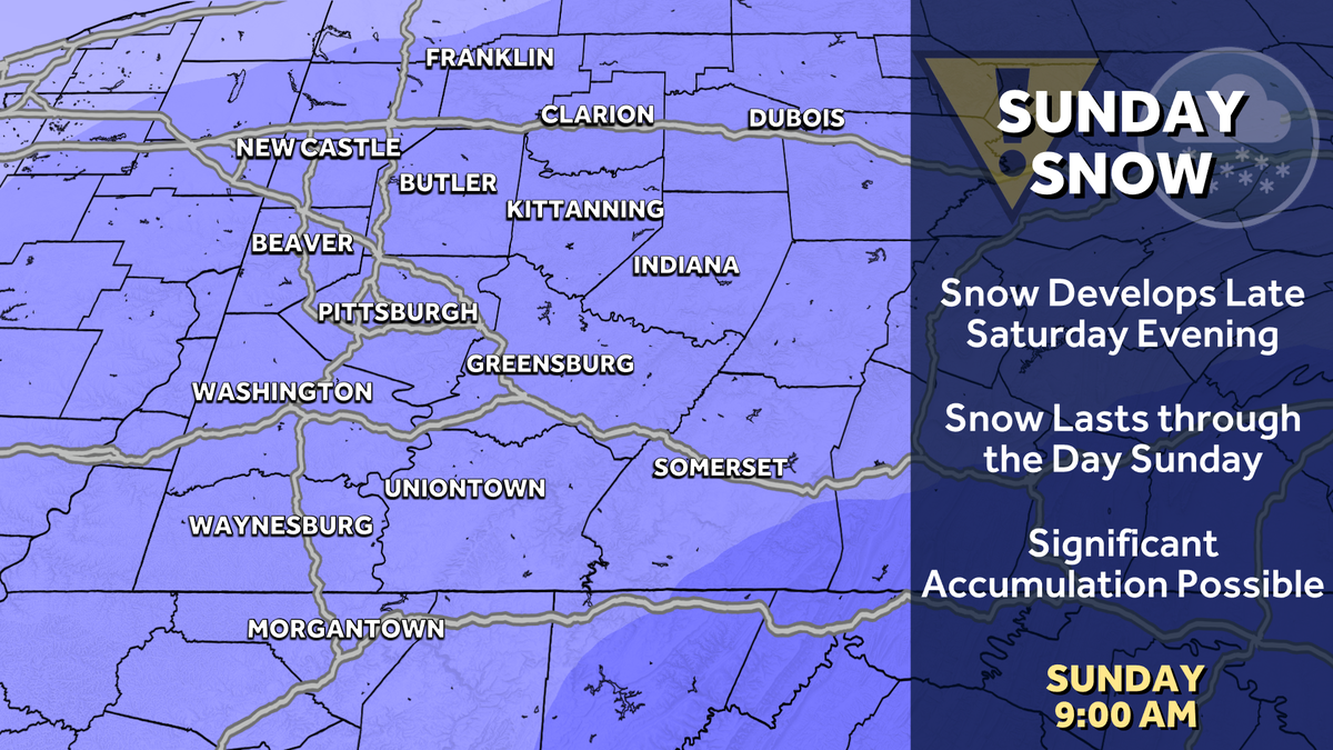
Hearst Owned
The two major models are in agreement of widespread snow on Sunday.
What we knowSnow likely starts late Saturday (after dinner) and lasts through the day SundaySnow could be heavy at timesThe heaviest snow is likely overnight Saturday into Sunday morningTravel will be difficult, especially in the morning hoursWhat we don’t knowHow much snow will fall? We are too far out for totals, and there is a range of possibilities, but significant snow seems certainWill it all be snow? Today, the European model has introduced the chance of seeing freezing rain or rain sneak in south of Pittsburgh. This is a new trend, but one worth watching as the exact track will be key to this.Timing of the event. While we have a solid idea of the overall timing of the event, a wiggle earlier or later of a few hours is always possible as we get closer.

Hearst Owned
A potential wintry mix may complicate the forecast for Sunday.
ImpactsTravel will be very difficult, especially Saturday night and early Sunday morningHeavy snow, and high snow totals, could cause power outagesBodily injury from shoveling snow is possible, especially if we see higher amounts or the snow is the heavy, wet kind that makes shoveling difficultWhat to look for
The forecast will continue to get fine-tuned as we get closer and our higher resolution models begin to analyze this event. The first, truly accurate snow totals likely won’t be out until Friday as we get a very clear picture of what should happen Sunday.
Now, though, is the time to make sure you are prepared for a potentially significant snowfall and limited outdoor activity. Make sure you have all supplies you need in case you are inside and/or without power for a few days.