
All eyes are on the weekend where we first see dangerous cold followed by the potential for significant snow Sunday.Winter Weather AdvisoryMore snow showers will be around overnight. Most locations will see a half an inch of snow total by Thursday morning. The Laurel Highlands could see an inch or two, and up to five inches of snow is possible near Interstate 80 where snow squalls are most likely.A Winter Weather Advisory has been issued for Clarion, Forest, Indiana, and Venango counties along with the ridges of Westmoreland, Fayette, and Preston counties until 10 a.m. Thursday. Severe Weather Alert Days this weekendWe dry out Thursday and Friday with temperatures near freezing Thursday and starting the tumble Friday with highs in the 20s.Saturday is a Severe Weather Alert Day as we see another round of dangerous cold. Wake-up temperatures will be near 0 with wind chills between -10 and -20 for most of Western PA. Temperatures and wind chills will barely improve as we head through the day.Sunday is also a Severe Weather Alert Day for snow. A system will approach from the south and bring snow, likely starting Saturday night and lasting through the day on Sunday. Models are still coming into in agreement on what will actually happen in Western PA. Areas of disagreement nclude timing of start and stop of precipitation, if some freezing rain mixes in south of Pittsburgh, and how much snow falls. The potential for a significant snow has increased and is only increasing as we approach the weekend.Models will come into closer agreemnt on Thursday and especially Friday. THURSDAY: Mostly cloudy and chilly. High: 35°, low: 18°.FRIDAY: Mostly cloudy. Cold High: 24°, low: 1°.SATURDAY – Severe Weather Alert Day: Dangerous cold with subzero wind chills. Late day snow likely. High: 14°, low: 8°.SUNDAY – Severe Weather Alert Day: Snow, potentially significant amount. High: 22°, low: 9°.
PITTSBURGH —
All eyes are on the weekend where we first see dangerous cold followed by the potential for significant snow Sunday.
Winter Weather Advisory

Hearst Owned
Snow showers will be around through Thursday morning.
More snow showers will be around overnight. Most locations will see a half an inch of snow total by Thursday morning. The Laurel Highlands could see an inch or two, and up to five inches of snow is possible near Interstate 80 where snow squalls are most likely.

Hearst Owned
Most locations will see less than one inch from snow Wednesday into Thursday.
A Winter Weather Advisory has been issued for Clarion, Forest, Indiana, and Venango counties along with the ridges of Westmoreland, Fayette, and Preston counties until 10 a.m. Thursday.

Hearst Owned
Winter Weather Advisory for snow squalls Wednesday into early Thursday.
Severe Weather Alert Days this weekend
We dry out Thursday and Friday with temperatures near freezing Thursday and starting the tumble Friday with highs in the 20s.

Hearst Owned
Wind chills could be as cold as -30 in the Laurel Highlands.
Saturday is a Severe Weather Alert Day as we see another round of dangerous cold. Wake-up temperatures will be near 0 with wind chills between -10 and -20 for most of Western PA. Temperatures and wind chills will barely improve as we head through the day.

Hearst Owned
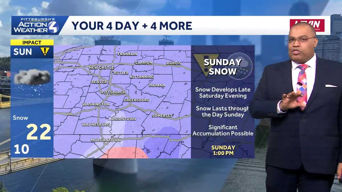
Significant snow is possible Sunday.
Sunday is also a Severe Weather Alert Day for snow. A system will approach from the south and bring snow, likely starting Saturday night and lasting through the day on Sunday. Models are still coming into in agreement on what will actually happen in Western PA. Areas of disagreement nclude timing of start and stop of precipitation, if some freezing rain mixes in south of Pittsburgh, and how much snow falls. The potential for a significant snow has increased and is only increasing as we approach the weekend.Models will come into closer agreemnt on Thursday and especially Friday.

Hearst Owned
Turning colder this weekend with dangerous cold Saturday and the potential for significant snow on Sunday.
THURSDAY: Mostly cloudy and chilly. High: 35°, low: 18°.
FRIDAY: Mostly cloudy. Cold High: 24°, low: 1°.
SATURDAY – Severe Weather Alert Day: Dangerous cold with subzero wind chills. Late day snow likely. High: 14°, low: 8°.
SUNDAY – Severe Weather Alert Day: Snow, potentially significant amount. High: 22°, low: 9°.