
All eyes are on the weekend where we first see dangerous cold followed by the potential for significant snow Sunday. A winter storm watch has been issued beginning Saturday evening. Winter Weather AdvisoryImpact day to kick off the morning with light snow showers around making slick road conditions. Little to no accumulation expected but the Laurel Highlands could see an inch or two. A winter weather advisory will remain in place until 10 a.m. for Mercer, Venango, Clarion, Eastern Westmoreland and Fayette, Indiana, Cambria, Somerset and Garrett county.Stay with WTAE.com and the WTAE app for breaking news updates.More: See current weather alerts for your countyInteractive radar: Track storms as they move through your areaLearn how to enable automatic weather alerts on the WTAE mobile appWinter Storm WatchWinter storm watch is in place from 7 p.m. Saturday through 1 p.m. Monday for the entire region. Severe Weather Alert Days this weekendWe dry out Thursday and Friday with temperatures near freezing Thursday and starting the tumble Friday with highs in the 20s.Saturday is a Severe Weather Alert Day as we see another round of dangerous cold. Wake-up temperatures will be near 0° with wind chills between -5° and -15° for most of Western PA. Temperatures and wind chills will barely improve as we head through the day.Sunday is also a Severe Weather Alert Day for snow. A system will approach from the south and bring snow, likely starting Saturday night and lasting through Sunday and into early Monday. Models are still coming into agreement on the timing of the storm. One scenario shows the snow starting Saturday night while the other scenario has it coming in early Sunday morning. The potential for a significant snow has increased and it still looks like the heaviest of snow will come on Sunday. Early estimate totals show around 6-10 inches around most of the area with 10+ inches in the higher elevations east. One caveat could be some of the warmer air hitting areas south of Pittsburgh which could cut down on snow totals. The latest model run has us still on the cold side, but we will be monitoring the storm as it continues to develop and prepare to push eastward.TODAY: Mostly cloudy to partly cloudy, breezy and chilly. High: 35°, low: 18°.FRIDAY: Mostly cloudy. Cold High: 24°, low: 1°.SATURDAY – Severe Weather Alert Day: Dangerous cold with subzero wind chills. Late day snow likely. High: 14°, low: 8°.SUNDAY – Severe Weather Alert Day: Snow, potentially significant amount. High: 22°, low: 9°.
All eyes are on the weekend where we first see dangerous cold followed by the potential for significant snow Sunday. A winter storm watch has been issued beginning Saturday evening.
Winter Weather Advisory
Impact day to kick off the morning with light snow showers around making slick road conditions.
Little to no accumulation expected but the Laurel Highlands could see an inch or two. A winter weather advisory will remain in place until 10 a.m. for Mercer, Venango, Clarion, Eastern Westmoreland and Fayette, Indiana, Cambria, Somerset and Garrett county.
Stay with WTAE.com and the WTAE app for breaking news updates.
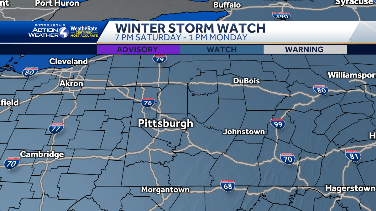
Winter Storm Watch
Winter storm watch is in place from 7 p.m. Saturday through 1 p.m. Monday for the entire region.

Severe Weather Alert Days this weekend
We dry out Thursday and Friday with temperatures near freezing Thursday and starting the tumble Friday with highs in the 20s.
Saturday is a Severe Weather Alert Day as we see another round of dangerous cold. Wake-up temperatures will be near 0° with wind chills between -5° and -15° for most of Western PA. Temperatures and wind chills will barely improve as we head through the day.

Sunday is also a Severe Weather Alert Day for snow. A system will approach from the south and bring snow, likely starting Saturday night and lasting through Sunday and into early Monday. Models are still coming into agreement on the timing of the storm.
One scenario shows the snow starting Saturday night while the other scenario has it coming in early Sunday morning. The potential for a significant snow has increased and it still looks like the heaviest of snow will come on Sunday.
Early estimate totals show around 6-10 inches around most of the area with 10+ inches in the higher elevations east.
One caveat could be some of the warmer air hitting areas south of Pittsburgh which could cut down on snow totals. The latest model run has us still on the cold side, but we will be monitoring the storm as it continues to develop and prepare to push eastward.

TODAY: Mostly cloudy to partly cloudy, breezy and chilly. High: 35°, low: 18°.
FRIDAY: Mostly cloudy. Cold High: 24°, low: 1°.
SATURDAY – Severe Weather Alert Day: Dangerous cold with subzero wind chills. Late day snow likely. High: 14°, low: 8°.
SUNDAY – Severe Weather Alert Day: Snow, potentially significant amount. High: 22°, low: 9°.