
Calming Winds Tonight; Mild Tuesday With Late PM Showers In South Central Pennsylvania
Overnight lows will drop to the upper 30s and low 40s with highs on Tuesday reaching the upper 60s. The strong wind gusts will calm down throughout the evening and overnight.
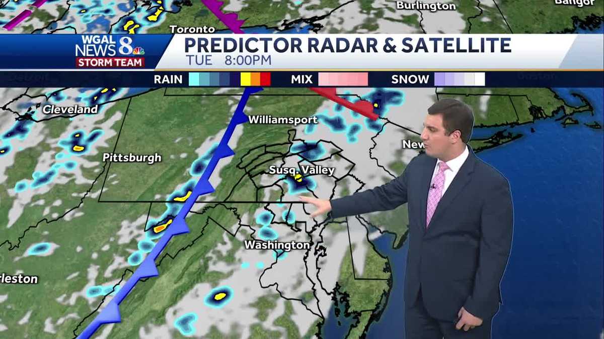
BACK TO YOU. AGAIN MONDAY EVENING. THOSE WINDS ARE GOING TO FINALLY CALM DOWN HERE AS WE GO INTO THE OVERNIGHT HOURS. AND THEN TOMORROW IT’S GOING TO BE MILD. TEMPERATURES WILL BE ABOVE AVERAGE, BUT WE DO HAVE SOME SHOWERS THAT WILL BE COMING IN LATER IN THE DAY. AND THEN FOR YOUR WEDNESDAY IT WILL BE COOLER AND BREEZY ONCE AGAIN AS WE GO INTO THE MIDDLE PART OF THE WEEK. BUT HERSHEY, RIGHT NOW YOU CAN SEE ALL THE FLAGS HERE IN THE BACKGROUND OR THE FOREGROUND THERE. THEY’RE GETTING A WORK OUT HERE THIS AFTERNOON. TEMPERATURES RIGHT NOW IN HERSHEY 62 DEGREES WITH GUSTS AROUND 35MPH. BUT EVEN SUSTAINED WINDS OVER 20 WITH THEM OUT OF THE WEST NORTHWEST THERE. SO IT IS DEFINITELY A BREEZY EVENING. TEMPERATURES AT 63 IN YORK AT 62 IN CARLISLE, 60 IN LANCASTER AT 64, IN GETTYSBURG, AS WELL AS CHAMBERSBURG. HERE’S A LOOK AT THE SUSTAINED WINDS. SO OUT OF THE WEST HERE, ANYWHERE FROM AROUND 20 TO SOME PLACES NEAR 50MPH, UP IN LEWISTOWN, CHAMBERSBURG, A BIT CALMER THERE IN YORK, AROUND NINE MILES PER HOUR. BUT THE WIND GUSTS SO FAR TODAY HAVE BEEN UP THERE AGAIN, AROUND 30 TO EVEN 40MPH. SOME CASES. BUT THEY DO CALM DOWN AS WE GO INTO THE EVENING AND OVERNIGHT HOURS HERE. SO THAT’S GOOD NEWS. YOU WILL NOT HAVE A LOUD NIGHT HERE WITH THE WINDS. SO THAT’S DEFINITELY ENCOURAGING. AND YOU GET SOME NICE SLEEP TONIGHT. HERE’S A LOOK AT LIVE RADAR. NETWORK WINDS ARE OUT OF THE WEST HERE. ALL THAT RAIN IS PULLING AWAY STILL. AND WE WILL KEEP A DRY NIGHT TONIGHT WITH A MOSTLY CLEAR SKY. ONCE THE CLOUDS BEGIN TO WORK THEIR WAY OUT. AND 50S WILL BE FOR THOSE TEMPERATURES TONIGHT. CLEAR SKIES, SEASONAL CHILL, TEMPERATURES DROPPING BACK INTO THE UPPER 30S AND LOW 40S OVERNIGHT TONIGHT HERE AND THEN AS WE GO INTO TOMORROW. MOSTLY SUNNY. BUT THEN IN THE LATE AFTERNOON AND EVENING WE WILL BE WATCHING A FEW SHOWERS HERE. JUST LIGHT SHOWERS SCATTERED IN NATURE, BUT TEMPERATURES. CHECK THAT OUT. GETTING CLOSE TO 70 DEGREES ONCE AGAIN ON YOUR TUESDAY. SO LET’S TIME THIS OUT FOR YOU HERE. WE GOT THE BREEZY CONDITIONS HERE THIS EVENING. THAT’S GOING TO PULL AWAY. AND THEN WE’LL HAVE A MOSTLY CLEAR SKY TONIGHT WITH WINDS COMING OUT OF THE SOUTH TOMORROW. BUT THEY WILL BE LIGHTER IN NATURE. 3:00 THE CLOUDS BEGIN TO INCREASE A LITTLE BIT FOR OUR WESTERN COMMUNITIES TOMORROW AFTERNOON. SO YOU’RE DRY THROUGHOUT MOST OF THE DAY AND THEN TOWARDS SUNSET. THAT’S WHEN THE CLOUDS COME IN. SOME SHOWERS AT TIMES. HERE AGAIN, VERY HIT OR MISS. NOTHING CRAZY THAT AS THIS COLD FRONT ROLLS ON THROUGH FOR TOMORROW. THEN AS WE HEAD INTO YOUR WEDNESDAY, IT’LL BE A MIX OF SUN AND CLOUDS, BUT IT DOES GET BREEZY ONCE AGAIN HERE AS WE HEAD INTO YOUR WEDNESDAY. IN FACT, WHEN WE LOOK AT PREDICTOR, YOU SEE THE GUSTS FORECAST RIGHT NOW. THEY CALM DOWN TONIGHT AND THEY REMAIN FAIRLY LOW AS WE GO THROUGH YOUR TUESDAY. BUT THEN WEDNESDAY THEY RAMP BACK UP INTO THE 20S AND EVEN A FEW 30 MILE PER HOUR GUSTS EXPECTED HERE. AS WE GO INTO YOUR WEDNESDAY, TEMPERATURES WILL BE BELOW AVERAGE, THOUGH FOR THE NEXT SEVERAL DAYS. AFTER YOUR TUESDAY HERE. OUR AVERAGE HIGHS IN THE LOW 60S, AND WE’LL BE IN THE 50S THERE FOR YOUR WEDNESDAY AND THURSDAY WHEN YOU HEAD TOWARDS THE END OF THE MONTH, THOUGH, CHANCES ARE THAT WE ARE A LITTLE BIT ABOVE AVERAGE HERE. BUT THEN WHEN WE LOOK AT THE PRECIPITATION, THIS DOES INCLUDE HALLOWEEN. BY THE WAY, IT IS ABOVE AVERAGE PRECIPITATION, SO IT DOES LOOK LIKE THE PATTERN BECOMES A LITTLE MORE UNSETTLED. AND THAT TEN DAY FORECAST SHOWS IT HERE AS WE APPROACH HALLOWEEN. SO WHEN YOU THINK ABOUT TRICK OR TREATING, JUST KEEP IN MIND YOU MIGHT WANT A COSTUME THAT HAS AN UMBRELLA WITH IT. BECAUSE GUYS, IT DOES LOOK LIKE AS WE HEAD TOWARDS THE END OF THAT TEN DAY FORECAST, THAT MOTHER NATURE BECOMES A L
Calming Winds Tonight; Mild Tuesday With Late PM Showers In South Central Pennsylvania
Overnight lows will drop to the upper 30s and low 40s with highs on Tuesday reaching the upper 60s. The strong wind gusts will calm down throughout the evening and overnight.

Updated: 4:40 PM EDT Oct 20, 2025
Good evening, The clouds will continue to decrease throughout the evening along with the strong wind gusts. Clear skies tonight and lighter winds will lead to a cool, but seasonable night in the low 40s.Plenty of sunshine expected to start the day Tuesday. Clouds will increase during the afternoon ahead of a cold front. Highs are milder in the mid to upper 60s. There may be a few showers in the late evening and early night. In the wake of the front, temperatures drop back to the 50s to around 60-degrees, with overnight lows in the 30s and 40s the rest of the week.A look ahead to next weekend shows a dry start Saturday with highs around 60 degrees. There is a chance for showers Sunday, but it doesn’t look like a washout at this point.There will be more rain chances the following week as we approach Halloween so stay tuned.Have a great evening!
Good evening,
The clouds will continue to decrease throughout the evening along with the strong wind gusts. Clear skies tonight and lighter winds will lead to a cool, but seasonable night in the low 40s.
Plenty of sunshine expected to start the day Tuesday. Clouds will increase during the afternoon ahead of a cold front. Highs are milder in the mid to upper 60s. There may be a few showers in the late evening and early night. In the wake of the front, temperatures drop back to the 50s to around 60-degrees, with overnight lows in the 30s and 40s the rest of the week.
A look ahead to next weekend shows a dry start Saturday with highs around 60 degrees. There is a chance for showers Sunday, but it doesn’t look like a washout at this point.
There will be more rain chances the following week as we approach Halloween so stay tuned.
Have a great evening!