
HOUR-BY-HOUR | Snow timeline for south-central Pennsylvania
TEAM FORECAST WITH CHIEF METEOROLOGIST CHRISTINE FERREIRA. GOOD MORNING. IT IS 522. I WANTED TO START YOU OUT WITH THE LATEST INFORMATION I RECEIVED OVERNIGHT, WHICH IS A WINTER STORM WATCH POSTED FOR THE SUSQUEHANNA VALLEY FROM 10 P.M. SATURDAY UNTIL 1 P.M. ON MONDAY. THIS WILL LIKELY BE UPGRADED TO A WINTER STORM WARNING COME TOMORROW. SO SUNDAY, OF COURSE, YOU KNOW THE BIG SNOW. WE ARE GOING TO WATCH IT DEVELOP SATURDAY NIGHT AND END EARLY MONDAY. SO SUNDAY IS REALLY THE HEART OF THE STORM. WE COULD SEE SIGNIFICANT SNOWFALL 12IN OR MORE POSSIBLE AND IT COULD EVEN MIX. NOW THIS IS SOMETHING NEW WITH SOME SLEET IN SOUTHEASTERN COUNTIES LATE ON SUNDAY, BUT THE BULK OF SNOW WILL ALREADY BE ON THE GROUND AT THAT TIME. IMPACTS HAZARDOUS TRAVEL. WE COULD SEE ONE INCH PER HOUR SNOWFALL RATES AT TIMES, FRIGID TEMPERATURES, AND THEN BEHIND THE STORM, BLOWING AND DRIFTING SNOW INTO MONDAY. SO WE’RE FAIRLY CONFIDENT THAT WE GET SIX INCHES OF SNOW. THAT’S HIGHLY LIKELY. LIKELY THAT WE COULD GET 12 NOW, POSSIBLE 18, BUT THAT MIGHT BE A LITTLE MUCH AND THERE’S A LOW CHANCE OF OVER 18IN OF SNOW ARE EXPECTED IMPACTS. OF COURSE, HAZARDOUS TRAVEL CONDITIONS, TRAVEL DISRUPTIONS WILL BE VERY HIGH CLOSINGS AS WELL. VISIBILITY COULD BE POOR AT TIMES, ESPECIALLY WHEN THAT SNOW COMES DOWN HEAVY AND WITH THE WIND PICKING UP BEHIND THE STORM, THERE MAY BE SOME POWER OUTAGES INTO MONDAY, SO ALL THINGS TO MONITOR AS WE HEAD TOWARD THE WEEKEND, AND WE’RE GOING TO HAVE SNOW TOTALS FOR YOU ON FRIDAY. HERE’S OUR NEWS EIGHT STORM TEAM FORECAST TODAY. A MIX OF CLOUDS AND SUNSHINE THIS MORNING. THERE MAY BE AN ISOLATED SNOW SHOWER, ESPECIALLY IN NORTHWESTERN COUNTIES FOR THE AFTERNOON. LOOK AT THE HIGH 44. THAT’S THE WARMEST TEMPERATURE YOU’RE GOING TO SEE IN THE ENTIRE TEN DAY FORECAST THIS EVENING. MOSTLY CLEAR, BREEZY AND CHILLY. TEMPERATURES WILL BE IN THE 30S NOW. TONIGHT UNDER PARTLY CLOUDY SKIES WILL SLIDE DOWN TO THE 20S, WHICH IS AVERAGE FOR THIS TIME OF THE YEAR. WE STILL HAVE THAT BRISK BREEZE TO BATTLE THOUGH, AND TOMORROW PARTLY SUNNY, DRY, COLD FRONT COMES THROUGH IN THE AFTERNOON. THE WIND PICKS UP AND THAT’S GOING TO DRIVE OUR WIND CHILLS TO SUBZERO LEVELS LATE TOMORROW NIGHT. SO THE WIND IS REALLY GOING TO PICK UP AND THE TEMPERATURES ARE GOING TO TANK BEHIND THAT ARCTIC FRONT. SO FRIDAY NIGHT, FRIDAY EVENING REALLY THROUGH SATURDAY AFTERNOON, WE HAVE TO BE MINDFUL OF THESE IMPACTFUL WIND CHILLS. THEY COULD BE SUBZERO. LET ME SHOW YOU HERE WITH THE PREDICTOR. YOU CAN SEE BY FRIDAY EVENING THOSE WIND CHILLS REALLY PLUMMET DOWN INTO THE NEGATIVE DIGITS. WE ARE BORDERLINE COLD WEATHER ADVISORY WITH THOSE WIND CHILLS, SO WE’LL LET YOU KNOW IF THAT’S ISSUED. BUT AS WE HEAD INTO SATURDAY MORNING, SUBZERO CHILLS ARE LIKELY. AND THEY DO IMPROVE TO THE SINGLE DIGITS SATURDAY AFTERNOON. BUT THIS JUST SETS UP THE ARCTIC AIR AHEAD OF OUR STORM. LUCKILY, IT’S NICE OUTSIDE THIS MORNING. I’D SAY 36 IS NICE IN LEWISTOWN, 35 IN LEBANON, 36 DEGREES IN LANCASTER. EVEN FOR HIGHS NEXT WEEK, YOU’RE NOT GOING TO SEE THOSE NUMBERS. WIND SPEEDS HAVE PICKED UP OVERNIGHT AND THEY’RE ABOUT 5 TO 15 RIGHT NOW. THEY’LL BE EVEN STRONGER 10 TO 20 LATER THIS AFTERNOON BEHIND THIS VERY WEAK BOUNDARY COLD FRONT RIGHT NOW IS FROM STATE COLLEGE TO LEWISTOWN. THERE COULD BE A COUPLE OF SNOW SHOWERS, BUT NOTHING SIGNIFICANT THAT WOULD SLOW DOWN YOUR MORNING TRAVELS ON OUR STORM TEAM LIVE RADAR NETWORK, THOUGH THERE’S A BOUNDARY OFFSHORE, ANOTHER ONE COMING IN FROM THE WEST. THERE’S JUST NO REAL COLD AIR UNTIL WE GET TO TOMORROW. SO HERE’S A LOOK AT THE PREDICTOR. I DO THINK WE SQUEEZE IN SOME SUNSHINE TODAY. AND THAT MEANS WITH HIGHS IN THE 40S AND THE SUN, IT IS YOUR OPTIMAL DAY TO GET OUTSIDE AND GET THOSE TASKS DONE BEFORE THE ARCTIC AIR SETS IN FOR FRIDAY, WE SHOULD SEE A MIX OF CLOUDS AND SUNSHINE. ONCE AGAIN, THAT DRY BOUNDARY COMES THROUGH, AND THAT’S REALLY THE LEADING EDGE OF THAT COLD ARCTIC AIR JUST AHEAD OF OUR WINTER STORM. SO SPEAKING OF THE WINTER STORM, HERE WE ARE AT 8:00 ON SATURDAY. YOU CAN SEE THE STORM COMING IN FROM THE WEST LATE, AND I’D SAY BY ABOUT 10 OR 11, EVEN MIDNIGHT, WE COULD START TO SEE THAT SNOW GENERATING. NOW AS WE HEAD INTO SUNDAY MORNING. THE SNOW COULD BE HEAVY AT TIMES. EVEN SUNDAY AFTERNOON WE COULD GET ONE INCH PER HOUR RATES AT TIMES. BUT HERE’S SOMETHING NEW THAT I’M WATCHING. YOU SEE THIS PINK DOWN HERE? SEE HOW IT JUST SQUEEZES INTO OUR SOUTHEASTERN COUNTIES? THAT’S A LITTLE BIT OF SLEEP. AND THAT COULD COME IN AT THE END OF THE STORM, WHEN MOST OF THE ACCUMULATIONS ARE ALREADY DOWN. BUT I WOULDN’T BE SHOCKED TO SEE SOME LOW LEVEL WARMING IN THE ATMOSPHERE AS LOW PRESSURE TRACKS OFF THE EAST COAST. THE SURFACE IS DEFINITELY GOING TO BE COLD, BUT IN THE LOWER LEVELS MID-LEVELS OF THE ATMOSPHERE, IT COULD WARM UP JUST A LITTLE BIT. NOW, OF COURSE, BEHIND THE STORM, BLOWING AND DRIFTING SNOW IS OUR BIG CONCERN ALL OF NEXT WEEK. IT IS JUST DOWNRIGHT FRIGID AND BLUSTERY. LOOK AT THOSE HIGHS THERE IN THE 20S. LOWS COULD VERY WELL BE IN THE SINGLE DIGITS. SO REGINA W
HOUR-BY-HOUR | Snow timeline for south-central Pennsylvania

Updated: 8:28 AM EST Jan 22, 2026
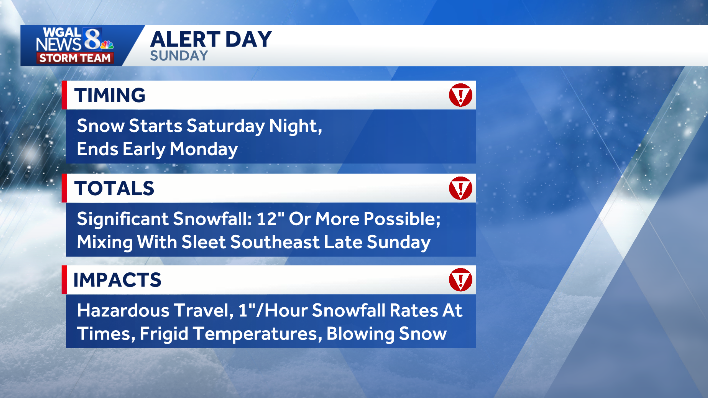
The WGAL News 8 Storm Team is closely tracking a major snowstorm headed for south-central Pennsylvania this weekend. The National Weather Service issued a Winter Storm Watch for all of the Susquehanna Valley counties in effect from 10 p.m. Saturday to 1 p.m. Monday. Hour-by-hour projections Snow develops late Saturday night.Snow continues Sunday morning and may become heavy at times.Snowfall rates could reach one inch per hour throughout the morning and afternoon.Roads will become snow-covered and hazardous.Warmer air may move into the lower atmosphere Sunday evening as low pressure shifts off the Delmarva coast.This could change snow to periods of sleet in the southeastern counties late Sunday night, after the bulk of the storm. Winds will strengthen on Monday, leading to blowing and drifting snow and bitterly cold wind chills.TotalsThe Susquehanna Valley is projected to get a foot or more of snow over about a 24-hour event. Six inches or more: Highly likely, over 80% chanceTwelve inches or more: Likely, about 60-80% chance18 inches or more: Possible, about 20-40% chance24 inches or more: Less likely ImpactsRoads will be snow-covered and dangerous. Travel delays and disruptions are expected. Visibility may be poor during heavier snowfall.The chance of sleet could make roads slick. Power outages are possible. Blowing and drifting snow is expected following the storm as winds increase. “Of course, hazardous travel conditions, travel disruptions will be very high closings as well. Visibility could be poor at times, especially when that snow comes down heavy and with the wind picking up behind the storm. There may be some power outages into Monday, so all things to monitor as we head toward the weekend,” WGAL Chief Meteorologist Christine Ferreira said.The WGAL News 8 Storm Team will continue to closely monitor this weekend’s snow and provide updates as new forecast models and data become available. Did you capture the snow and would like to share with News 8? Send us your photos or videos at https://www.wgal.com/upload.SOUTH-CENTRAL PA WEATHER RESOURCES: INTERACTIVE RADAR | ACTIVE WEATHER ALERTS | CURRENT CONDITIONS | HOURLY FORECAST | 10-DAY FORECAST | WEEKEND FORECAST | MAP ROOM | DOWNLOAD THE APP | WEATHER EMAILS
The WGAL News 8 Storm Team is closely tracking a major snowstorm headed for south-central Pennsylvania this weekend.
The National Weather Service issued a Winter Storm Watch for all of the Susquehanna Valley counties in effect from 10 p.m. Saturday to 1 p.m. Monday.
Hour-by-hour projections Snow develops late Saturday night.Snow continues Sunday morning and may become heavy at times.Snowfall rates could reach one inch per hour throughout the morning and afternoon.Roads will become snow-covered and hazardous.Warmer air may move into the lower atmosphere Sunday evening as low pressure shifts off the Delmarva coast.This could change snow to periods of sleet in the southeastern counties late Sunday night, after the bulk of the storm. Winds will strengthen on Monday, leading to blowing and drifting snow and bitterly cold wind chills.

Totals
The Susquehanna Valley is projected to get a foot or more of snow over about a 24-hour event.
Six inches or more: Highly likely, over 80% chanceTwelve inches or more: Likely, about 60-80% chance18 inches or more: Possible, about 20-40% chance24 inches or more: Less likely


ImpactsRoads will be snow-covered and dangerous. Travel delays and disruptions are expected. Visibility may be poor during heavier snowfall.The chance of sleet could make roads slick. Power outages are possible. Blowing and drifting snow is expected following the storm as winds increase.
“Of course, hazardous travel conditions, travel disruptions will be very high closings as well. Visibility could be poor at times, especially when that snow comes down heavy and with the wind picking up behind the storm. There may be some power outages into Monday, so all things to monitor as we head toward the weekend,” WGAL Chief Meteorologist Christine Ferreira said.


The WGAL News 8 Storm Team will continue to closely monitor this weekend’s snow and provide updates as new forecast models and data become available.
Did you capture the snow and would like to share with News 8? Send us your photos or videos at https://www.wgal.com/upload.
SOUTH-CENTRAL PA WEATHER RESOURCES: INTERACTIVE RADAR | ACTIVE WEATHER ALERTS | CURRENT CONDITIONS | HOURLY FORECAST | 10-DAY FORECAST | WEEKEND FORECAST | MAP ROOM | DOWNLOAD THE APP | WEATHER EMAILS