
More than a foot of snow headed for Susquehanna Valley | Latest totals
STORM TEAM FORECAST WITH CHIEF METEOROLOGIST CHRISTINE FERREIRA. GOOD MORNING. IT IS 646. I GOT SOME NEW INFORMATION FROM THE NATIONAL WEATHER SERVICE OVERNIGHT. THEY HAVE ISSUED A WINTER STORM WATCH FOR OUR ENTIRE AREA FROM 10 P.M. SATURDAY UNTIL 1 P.M. MONDAY, AND THAT WILL LIKELY BE UPGRADED TO A WARNING COME TOMORROW. SO TIMING ON SUNDAY. SNOW. YOU KNOW IT’S GOING TO BE A BIG ONE RIGHT? IT’S GOING TO START SATURDAY NIGHT AND EARLY MONDAY. THE BULK OF SNOW FALLS ON SUNDAY. WE’RE TALKING ABOUT 12IN OR MORE POSSIBLE A SIGNIFICANT SNOWSTORM FOR THE SUSQUEHANNA VALLEY. BUT HERE’S SOMETHING NEW. THERE COULD BE SOME MIXING WITH SLEET IN SOUTHEASTERN COUNTIES LATE ON SUNDAY, BUT I THINK THE BULK OF ACCUMULATIONS WILL HAPPEN BEFORE THEN. BEFORE THAT CHANGEOVER TO POSSIBLE SLEET. LATE IMPACTS. OF COURSE WE HAVE HAZARDOUS TRAVEL ALL DAY SUNDAY. WE COULD SEE SNOWFALL RATES OF ONE INCH PER HOUR OR MORE AT TIMES. FRIGID TEMPERATURES COME ALONG WITH THIS SNOW AND THEN BEHIND THE STORM, WE’RE GOING TO BE DEALING WITH BLOWING AND DRIFTING SNOW ON MONDAY. SNOWFALL. CONFIDENCE. LET’S TALK ABOUT IT. SIX INCHES, HIGHLY LIKELY ACROSS THE AREA. 12IN OF SNOW. THAT’S LIKELY 18IN POSSIBLE, BUT ONCE YOU GET ABOVE THAT, IT IS A LOWER CHANCE WE WILL HAVE SNOW TOTALS ON THE STORM TOMORROW MORNING. AT THIS TIME, HERE’S THE EXPECTED IMPACTS. ROAD CONDITIONS, HAZARDOUS TRAVEL ALL DAY SUNDAY, EVEN INTO MONDAY, TRAVEL DISRUPTIONS ARE GOING TO BE VERY HIGH. REMEMBER THOSE CANCELLATIONS. THINK ABOUT SCHOOLS EARLY NEXT WEEK. DOESN’T LOOK LIKELY TO HAVE SCHOOL ON MONDAY, ESPECIALLY WITH BLOWING AND DRIFTING SNOW. SO THAT COULD CAUSE SOME POWER OUTAGES BEHIND THE STORM AND DURING THE STORM, ESPECIALLY AT THE PEAK. VISIBILITY COULD BE POOR AT TIMES AS SNOW FALLS AT A HEAVY RATE. SO TODAY YOU CAN PUT THAT IN THE BACK OF YOUR MIND FOR NOW, BECAUSE I WANT YOU TO ENJOY THIS TEMPERATURE. 44 DEGREES IS OUR HIGH TODAY. IT’S GOING TO BE BREEZY, BUT IT WILL BE MILDER THAN YESTERDAY. AND IT IS THE WARMEST DAY IN THE TEN DAY FORECAST BY FAR. YOU HAVE TO DOUBLE THE HIGHS NEXT WEEK TO GET TO THAT NUMBER. SO DO YOUR RUNNING AROUND TODAY, PREPARE FOR THE STORM AND ENJOY THE SUN AND THE WARMTH FOR TONIGHT. PARTLY CLOUDY, A BRISK BREEZE. IT’S GOING TO FEEL LIKE THE TEENS THOUGH, WITH TEMPERATURES IN THE 20S. AND THEN TOMORROW WE HAVE PARTLY SUNNY SKIES TURNING BLUSTERY AGAIN. ARCTIC AIR. SO TOMORROW WE HIT THE 30S. BUT BY TOMORROW EVENING, LET ME SHOW YOU WHAT IT’S GOING TO FEEL LIKE. THIS IS AT 7 P.M. FRIDAY. LOOK AT THOSE WIND CHILLS. THEY’RE GOING TO BE SUBZERO LATE FRIDAY AS THAT ARCTIC AIR REALLY SETTLES IN OVERNIGHT FRIDAY NIGHT INTO SATURDAY MORNING, EVEN BY NOON ON SATURDAY, WE COULD STILL HAVE SOME SUBZERO CHILLS AND THEY’LL GET TO THE SINGLE DIGITS SATURDAY AFTERNOON. SO THE ARCTIC AIR SETTLES IN AHEAD OF THIS WINTER STORM. RIGHT NOW, THOUGH, IT’S 36 IN CARLISLE, NEARLY 40 IN YORK, 36 IN LANCASTER. JUST YESTERDAY AT THIS TIME, WE HAD LOWS THAT WERE BELOW FREEZING IN SOME AREAS. SO THAT’S A HUGE IMPROVEMENT. WIND SPEEDS THERE STILL GOING TO COME AT YOU TODAY OUT OF THE WEST AT ABOUT 10 TO 20. SO THAT WILL PUT A LITTLE NIP IN THE AIR. BUT STILL ALL THINGS CONSIDERED 44 FOR OUR HIGH TODAY. RIGHT NOW THERE’S A BOUNDARY PASSING THROUGH WESTERN PENNSYLVANIA. IT COULD PRODUCE A SNOW SHOWER THIS MORNING, ESPECIALLY IN MIFFLIN COUNTY, JUNIATA COUNTY. I’LL KEEP AN EYE ON THAT, BUT I HAVEN’T SEEN TOO MUCH OF DISRUPTIVE SNOW SO FAR. OVERNIGHT. BOUNDARY PASSES. TODAY WE GET INTO SOME SUNSHINE. WE GET THOSE 40S TOMORROW. HERE COMES THE SECONDARY FRONT. AND THAT’S THE LEADING EDGE OF ARCTIC AIR. SO GET READY FOR THAT BLAST FRIDAY EVENING, FRIDAY NIGHT INTO SATURDAY MORNING OF SUBZERO WIND. CHILLS. NOW HIGH PRESSURE MOVES OVERHEAD. SATURDAY AFTERNOON SETS US UP FOR THIS STORM THAT’S GOING TO HOLD OFF THE SNOW UNTIL LATE. SO IF YOU NEED TO GET THINGS DONE ON SATURDAY, YOU’RE STILL GOOD TO GO UNTIL AFTER DARK. WELL AFTER DARK. SO I THINK EIGHT 9:10 P.M. ON SATURDAY, EVEN AROUND MIDNIGHT FOR SOME, WE’LL START TO SEE THAT SNOW CREEPING INTO THE AREA. IT COULD BE HEAVY AT TIMES ON SUNDAY MORNING. EVEN SUNDAY AFTERNOON. AND THEN HERE’S THE NEW DATA. YOU SEE THIS MIXED LINE COMING IN THAT COULD TRANSITION SOME SPOTS INTO SLEET AT THE END OF THE STORM ON SUNDAY NIGHT, SO WE WILL KEEP YOU UPDATED. MONDAY IS BLUSTER
More than a foot of snow headed for Susquehanna Valley | Latest totals

Updated: 9:00 AM EST Jan 22, 2026
A major snowstorm is headed for south-central Pennsylvania this weekend. A Winter Storm Watch was issued for all of the Susquehanna Valley from Saturday night through Monday morning. This could be upgraded to a Winter Storm Warning. What to know “As we head into Saturday morning, subzero chills are likely. And they do improve to the single digits Saturday afternoon. But this just sets up the Arctic Air ahead of our storm,” WGAL Chief Meteorologist Christine Ferreira said.Friday is an Impact Night starting at 6 p.m. for sub-zero wind chills. Saturday is an Impact Day for sub-zero wind chills in the morning and single-digit wind chills in the afternoon.Because of heavy snow, Sunday is an Alert Day, meaning the day could feature the threat of extreme, severe, and possibly life-threatening weather. Monday is an Impact Day, meaning the day’s weather could disrupt your normal daily schedule or routine. More than a foot of snowThe Susquehanna Valley is expected to get over a foot of snow or more this weekend.Six inches or more: HIGHLY LIKELYTwelve inches or more: LIKELY18 inches or more: POSSIBLE24 inches or more: LOW CHANCE Snow timing, typeSnow will develop late Saturday night and end early Monday. Sunday is the heart of the storm. One inch of snow an hour is possible at times. Low pressure will move off the coast of Delmarva in the evening which could change snow to a period of sleet in the southeastern counties late Sunday, after the bulk of the storm. Impacts: Travel, visibility, power Roads will be snow-covered and hazardous. Travel delays and disruptions are expected. Visibility may be poor during heavier snowfall. Power outages are possible. Blowing and drifting snow expected following the storm. Last significant snow?The last time the Susquehanna Valley picked up more than a foot of snow in a two-day stretch was in 2021 on Jan. 31 and Feb. 1, when about 12.5 inches fell. SOUTH-CENTRAL PA WEATHER RESOURCES: INTERACTIVE RADAR | ACTIVE WEATHER ALERTS | CURRENT CONDITIONS | HOURLY FORECAST | 10-DAY FORECAST | WEEKEND FORECAST | MAP ROOM | DOWNLOAD THE APP | WEATHER EMAILS
A major snowstorm is headed for south-central Pennsylvania this weekend.
A Winter Storm Watch was issued for all of the Susquehanna Valley from Saturday night through Monday morning. This could be upgraded to a Winter Storm Warning.

What to know
“As we head into Saturday morning, subzero chills are likely. And they do improve to the single digits Saturday afternoon. But this just sets up the Arctic Air ahead of our storm,” WGAL Chief Meteorologist Christine Ferreira said.
Friday is an Impact Night starting at 6 p.m. for sub-zero wind chills. Saturday is an Impact Day for sub-zero wind chills in the morning and single-digit wind chills in the afternoon.Because of heavy snow, Sunday is an Alert Day, meaning the day could feature the threat of extreme, severe, and possibly life-threatening weather. Monday is an Impact Day, meaning the day’s weather could disrupt your normal daily schedule or routine.

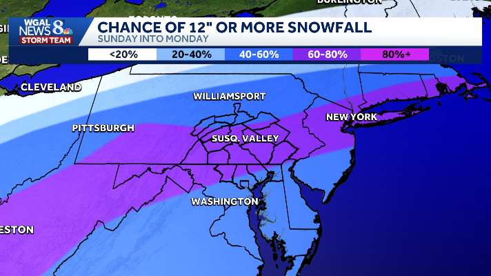
More than a foot of snow
The Susquehanna Valley is expected to get over a foot of snow or more this weekend.
Six inches or more: HIGHLY LIKELYTwelve inches or more: LIKELY18 inches or more: POSSIBLE24 inches or more: LOW CHANCE


Snow timing, typeSnow will develop late Saturday night and end early Monday. Sunday is the heart of the storm. One inch of snow an hour is possible at times. Low pressure will move off the coast of Delmarva in the evening which could change snow to a period of sleet in the southeastern counties late Sunday, after the bulk of the storm.

Impacts: Travel, visibility, power Roads will be snow-covered and hazardous. Travel delays and disruptions are expected. Visibility may be poor during heavier snowfall. Power outages are possible. Blowing and drifting snow expected following the storm.


Last significant snow?
The last time the Susquehanna Valley picked up more than a foot of snow in a two-day stretch was in 2021 on Jan. 31 and Feb. 1, when about 12.5 inches fell.

SOUTH-CENTRAL PA WEATHER RESOURCES: INTERACTIVE RADAR | ACTIVE WEATHER ALERTS | CURRENT CONDITIONS | HOURLY FORECAST | 10-DAY FORECAST | WEEKEND FORECAST | MAP ROOM | DOWNLOAD THE APP | WEATHER EMAILS