
All right, I hope you all are having *** good morning, but all eyes on the weekend storm, and we’ve been fine tuning it. Now we do have it down to about two scenarios, so it does look like, and what’s been pretty consistent is Saturday morning, early Saturday afternoon, still looks good minus the subzero wind chills we’ll be dealing with, though we do have *** severe weather alert day for Saturday and Sunday. Sunday mainly the snow, but we’re talking that wind chills about 5 to 5. 15 below zero as we kick off our weekend. Then the scenario one with the snow, it looks like we could start to see it as we get into Saturday evening. Some of the heavier snow Saturday late night into Sunday morning and afternoon. That’s scenario one. As we get into scenario two, the timing is where it changes *** little bit. It does look like we could start to see some of the heavier snow as we get into Sunday. Morning and afternoon hours lingering into the evening, so I mean like late morning getting closer to lunchtime, but those are the scenarios with the timing of the heaviest snow. It’s also been consistent that Sunday looks to be the worst day. And what’s changed *** little bit is this is going to extend now into Monday. So Monday morning commute could be *** little messy. That second scenario I was telling you about we could still have heavy snowfall in. To Monday morning we are looking around right now locally 6 to 10 inches and then into the higher elevations 10+ inches. These numbers still could change. They could go up, they could go down. We could see some of that warmer air trying to work its way in. We have *** lot of scenarios because this storm system is still out near New Mexico. It’s gonna travel south and then shoot up the East Coast, and we have been on the colder side of it, so hopefully it holds off.
Pennsylvania’s Watches & Warnings: Weekend snowstorm outlook

Updated: 10:52 AM EST Jan 22, 2026
Pennsylvania is bracing for a major weekend snowstorm, set to bring several inches of snow across the commonwealth.Ahead of the storm, the National Weather Service has issued multiple warnings and advisories to keep residents prepared. Stay with WTAE.com and the WTAE app for breaking news updates.More: See current weather alerts for your countyInteractive radar: Track storms as they move through your areaLearn how to enable automatic weather alerts on the WTAE mobile appWinter Storm Watch WHEN: 7 p.m. on Saturday through 1 p.m. on Monday Periods of moderate to heavy snow are expected over the weekend across Western Pennsylvania, with significant snowfall. Early estimate totals show around 6-10 inches around most of the area with 10+ inches in the higher elevations east.Travel during this time could be difficult to impossible with conditions sticking around to impact your Monday morning commute. All Western Pennsylvania counties including Allegheny County, Beaver County, Armstrong County, Butler County, Lawrence County, Washington County, Greene County, Westmoreland County, Indiana County and Fayette County are under this watch. Looking for a full forecast: Pittsburgh’s Action News 4 meteorologists have you coveredA breakdown of the next three daysTODAY: Mostly cloudy to partly cloudy, breezy and chilly. High: 35°, low: 18°.FRIDAY: Mostly cloudy. Cold High: 24°, low: 1°.SATURDAY – Severe Weather Alert Day: Dangerous cold with subzero wind chills. Late day snow likely. High: 14°, low: 8°.SUNDAY – Severe Weather Alert Day: Snow, potentially significant amount. High: 22°, low: 9°.
PITTSBURGH —
Pennsylvania is bracing for a major weekend snowstorm, set to bring several inches of snow across the commonwealth.
Ahead of the storm, the National Weather Service has issued multiple warnings and advisories to keep residents prepared.
Stay with WTAE.com and the WTAE app for breaking news updates.
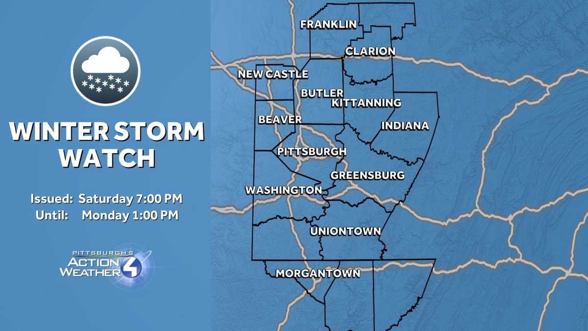
Winter Storm Watch
WHEN: 7 p.m. on Saturday through 1 p.m. on Monday

Periods of moderate to heavy snow are expected over the weekend across Western Pennsylvania, with significant snowfall.
Early estimate totals show around 6-10 inches around most of the area with 10+ inches in the higher elevations east.
Travel during this time could be difficult to impossible with conditions sticking around to impact your Monday morning commute.
All Western Pennsylvania counties including Allegheny County, Beaver County, Armstrong County, Butler County, Lawrence County, Washington County, Greene County, Westmoreland County, Indiana County and Fayette County are under this watch.

Looking for a full forecast: Pittsburgh’s Action News 4 meteorologists have you covered
A breakdown of the next three days
TODAY: Mostly cloudy to partly cloudy, breezy and chilly. High: 35°, low: 18°.
FRIDAY: Mostly cloudy. Cold High: 24°, low: 1°.
SATURDAY – Severe Weather Alert Day: Dangerous cold with subzero wind chills. Late day snow likely. High: 14°, low: 8°.
SUNDAY – Severe Weather Alert Day: Snow, potentially significant amount. High: 22°, low: 9°.