
Our forecast models continue to trend upward with snowfall totals across Western Pennsylvania with our system that gets here this weekend. There are still plenty of questions, but the picture of what will unfold this weekend continues to clear up with each hour we get closer to Sunday.In advance, a Winter Storm Watch is in effect for all of Western PA from 7 p.m. Saturday to 1 p.m. Monday. This will be upgraded Friday night, likely to a Winter Storm Warning.>> See the full list of warnings, watches and advisories. What to KnowSaturday is a Severe Weather Alert Day. Wind chills in the morning could be as cold as -20°. Wind chills will stay at or below zero through the day.The snow likely starts to arrive late Saturday, as early as 6 p.m. There is still timing start differences, so this may change.Sunday is a Severe Weather Alert Day. It will snow all day Sunday. The heaviest snow timeframe is still a question, based on when snow starts, but could be early in the morning or in the afternoon.There is the potential for freezing rain and/or sleet mixing in south of Interstate 70 through the afternoon on Sunday. This would drop snowfall totals but increase icing concerns.Snow could last through midday Monday. Cold weather will last for all of next week.Snow timing and precipitation typeWhile most of us will see just snow, there is the potential that locations south of Pittsburgh to see a mix of sleet and or freezing rain. Warm air will be surging northward as the system approaches us and passes to the south. How far north the warm air gets is still a question, but the greatest chance is south of Pittsburgh.Snow will likely start Saturday evening, but snow could start as late as early Sunday morning. The start time of the snow will determine when the heaviest snow gets here. If we start snow late Saturday, the heaviest snow will fall Sunday morning. If snow doesn’t start until Sunday morning, the heaviest snow will fall Sunday afternoon. In the heaviest snow, snowfall rates of an inch or more per hour are likely.Despite timing differences in the start and heaviest snowfall times, models are coming into good agreement on the amount of snow we will see.ImpactsTravel will deteriorate rapidly once the snow starts to fall. Travel will also be very difficult during the heaviest snowfall times, as the amount of snow falling will likely be more than crews can keep up with to keep roads in good condition.Visibility will be poor during the heavier snowfall periods and low during the entire event as snow is falling.Monday morning’s commute could also be tricky as snow will likely still be falling and crews will still be working to clear roads, especially neighborhood and non-mainline roads.Once the snow starts to fall, if you do not have to travel, it would be best to ride out the storm.Rare StormThe last time Pittsburgh saw snowfall of more than 10 inches in one day was February 5, 2010. That was Snowmageddon.
PITTSBURGH —
Our forecast models continue to trend upward with snowfall totals across Western Pennsylvania with our system that gets here this weekend.
There are still plenty of questions, but the picture of what will unfold this weekend continues to clear up with each hour we get closer to Sunday.
In advance, a Winter Storm Watch is in effect for all of Western PA from 7 p.m. Saturday to 1 p.m. Monday. This will be upgraded Friday night, likely to a Winter Storm Warning.
>> See the full list of warnings, watches and advisories.

Hearst Owned
Winter Storm Watch for all of Western PA this wekeend.
What to Know
Saturday is a Severe Weather Alert Day. Wind chills in the morning could be as cold as -20°. Wind chills will stay at or below zero through the day.The snow likely starts to arrive late Saturday, as early as 6 p.m. There is still timing start differences, so this may change.Sunday is a Severe Weather Alert Day. It will snow all day Sunday. The heaviest snow timeframe is still a question, based on when snow starts, but could be early in the morning or in the afternoon.There is the potential for freezing rain and/or sleet mixing in south of Interstate 70 through the afternoon on Sunday. This would drop snowfall totals but increase icing concerns.Snow could last through midday Monday. Cold weather will last for all of next week.
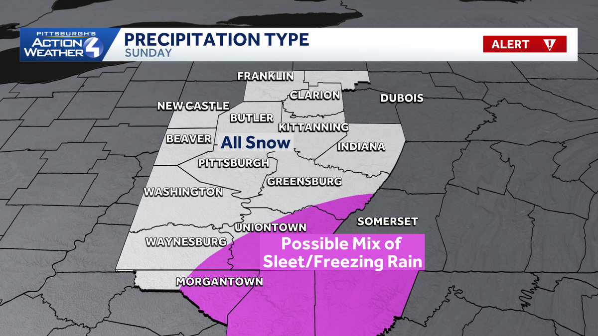
Snow timing and precipitation type
While most of us will see just snow, there is the potential that locations south of Pittsburgh to see a mix of sleet and or freezing rain. Warm air will be surging northward as the system approaches us and passes to the south. How far north the warm air gets is still a question, but the greatest chance is south of Pittsburgh.

Hearst Owned
Sleet and/or freezing rain could mix in south of Pittsburgh on Sunday.
Snow will likely start Saturday evening, but snow could start as late as early Sunday morning. The start time of the snow will determine when the heaviest snow gets here. If we start snow late Saturday, the heaviest snow will fall Sunday morning. If snow doesn’t start until Sunday morning, the heaviest snow will fall Sunday afternoon. In the heaviest snow, snowfall rates of an inch or more per hour are likely.
Despite timing differences in the start and heaviest snowfall times, models are coming into good agreement on the amount of snow we will see.
Impacts
Travel will deteriorate rapidly once the snow starts to fall. Travel will also be very difficult during the heaviest snowfall times, as the amount of snow falling will likely be more than crews can keep up with to keep roads in good condition.
Visibility will be poor during the heavier snowfall periods and low during the entire event as snow is falling.
Monday morning’s commute could also be tricky as snow will likely still be falling and crews will still be working to clear roads, especially neighborhood and non-mainline roads.

Hearst Owned
Travel will be difficult once snow starts this weekend.
Once the snow starts to fall, if you do not have to travel, it would be best to ride out the storm.
Rare Storm
The last time Pittsburgh saw snowfall of more than 10 inches in one day was February 5, 2010. That was Snowmageddon.