
YESTERDAY. IT WAS NOT BAD. YOU KNOW, FOR THIS TIME OF YEAR WASN’T BAD. COLDS COMING, COLDS COMING AND I CAN SEE IT ON THE HORIZON. I WANT TO SHOW YOU THIS ARCTIC FRONT THAT’S UP TO OUR NORTH. THAT IS GOING TO SET THE STAGE FOR OUR WINTER STORM. NOW THIS FRONT COMES THROUGH DRY THIS AFTERNOON, BUT IT WILL ROUGH UP THE WIND A LITTLE BIT. YOU CAN SEE OUR WIND SPEEDS INCREASING AS WE HEAD TOWARD EVENING. WE’RE GOING TO SEE WIND SPEEDS ABOUT 10 TO 20MPH OVERNIGHT TONIGHT. AND THAT IS REALLY GOING TO GIVE US SOME COLD WIND CHILLS AS TEMPERATURES PLUMMET RIGHT NOW. 27 IN LEWISTOWN, 25 IN HARRISBURG. THESE ARE TYPICAL TEMPERATURES FOR THIS TIME OF THE YEAR. IT’S 23 DEGREES IN LANCASTER TODAY. WE DO GET UP INTO THE 30S, BUT IT WILL FEEL LIKE THE 20S WITH THAT PESKY BREEZE THAT WE’VE HAD FOR THE PAST COUPLE OF DAYS. NOW, LET ME SHOW YOU HOW COLD IT WILL FEEL TOMORROW. WE START OUT WITH WIND CHILLS BELOW ZERO IN THE MORNING, AND ONLY GET TO THOSE SINGLE DIGIT CHILLS IN THE AFTERNOON. OUR HIGH TOMORROW IS JUST A MEASLY 18 DEGREES. SO HERE’S A LOOK AT OUR WEATHER PLANNER FOR TODAY. WE SEE INCREASING CLOUDS THIS MORNING, A MIX OF CLOUDS AND SUNSHINE INTO THE AFTERNOON, AND THEN PARTLY CLOUDY SKIES WITH SUBZERO WIND CHILLS AS WE HEAD TOWARD EVENING. ALL RIGHT, SO THE WINTER STORM ON SUNDAY. I THINK IT’S A FAIRLY UNIFORM AREA OF 12 TO 18IN ACROSS THE SUSQUEHANNA VALLEY. I AM WATCHING THE SLEET LINE, THOUGH. I THINK SOUTHERN COUNTIES COULD MIX WITH SLEET AND THAT MIGHT CUT DOWN TOTALS. SO I’M GETTING SOME MORE INFORMATION HOUR BY HOUR ON THAT, WHERE EXACTLY THAT LINE SETS UP AND HOW IT IMPACTS OUR TOTALS. SO WE’LL KEEP YOU UPDATED BECAUSE THAT’S THE HIGHEST AREA OF UNCERTAINTY ON OUR MAP HERE. BUT IT’S GOING TO BE A FOOT OF SNOW FOR MUCH
COLD WEATHER ADVISORY | Bitter wind chills to drop 10 below zero in south-central Pennsylvania

Updated: 5:46 AM EST Jan 23, 2026
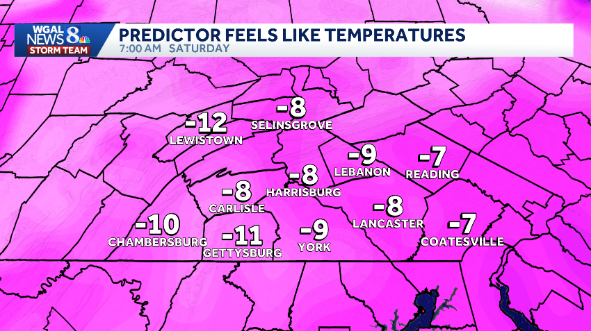
The National Weather Service issued a Cold Weather Advisory for all of south-central Pennsylvania as wind chills are expected to drop as low as 10 degrees below zero. The advisory is in effect for the following counties from 10 p.m. Friday to 10 a.m. Saturday:AdamsCumberlandDauphinFranklinLancasterLebanonPerrySchuylkillYorkIn Juniata and Mifflin counties, the Cold Weather Advisory is in effect from 6 p.m. Friday to 10 a.m. Saturday. Impact Friday and SaturdayDue to the bitterly cold wind chills, Friday is an Impact Night and Saturday is an Impact Day, meaning the day’s weather could disrupt your normal daily schedule or routine.An Arctic front is expected to move into the Susquehanna Valley around 6 p.m. Friday, bringing stronger winds and pushing wind chills below zero. Those sub-zero wind chills will continue Saturday morning before reaching single-digit wind chills in the afternoon. Safety precautionsOfficials warned the bitter wind chills could lead to hypothermia for anyone who is outdoors without proper protection.Residents are urged to limit time outside and dress in warm layers, including a hat and gloves, especially when traveling.SOUTH-CENTRAL PA WEATHER RESOURCES: INTERACTIVE RADAR | ACTIVE WEATHER ALERTS | CURRENT CONDITIONS | HOURLY FORECAST | 10-DAY FORECAST | WEEKEND FORECAST | MAP ROOM | DOWNLOAD THE APP | WEATHER EMAILS
The National Weather Service issued a Cold Weather Advisory for all of south-central Pennsylvania as wind chills are expected to drop as low as 10 degrees below zero.
The advisory is in effect for the following counties from 10 p.m. Friday to 10 a.m. Saturday:
AdamsCumberlandDauphinFranklinLancasterLebanonPerrySchuylkillYork
In Juniata and Mifflin counties, the Cold Weather Advisory is in effect from 6 p.m. Friday to 10 a.m. Saturday.

Impact Friday and Saturday
Due to the bitterly cold wind chills, Friday is an Impact Night and Saturday is an Impact Day, meaning the day’s weather could disrupt your normal daily schedule or routine.
An Arctic front is expected to move into the Susquehanna Valley around 6 p.m. Friday, bringing stronger winds and pushing wind chills below zero.
Those sub-zero wind chills will continue Saturday morning before reaching single-digit wind chills in the afternoon.


Safety precautions
Officials warned the bitter wind chills could lead to hypothermia for anyone who is outdoors without proper protection.
Residents are urged to limit time outside and dress in warm layers, including a hat and gloves, especially when traveling.


SOUTH-CENTRAL PA WEATHER RESOURCES: INTERACTIVE RADAR | ACTIVE WEATHER ALERTS | CURRENT CONDITIONS | HOURLY FORECAST | 10-DAY FORECAST | WEEKEND FORECAST | MAP ROOM | DOWNLOAD THE APP | WEATHER EMAILS