
NEW TOTAL MAPS: Weekend storm could dump 1-2 inches of snow per hour in Pennsylvania
PREVENT FUTURE MID-AIR COLLISIONS NEAR THE AIRPORT. NOW, THE WGAL NEWS EIGHT STORM TEAM FORECAST, WITH CHIEF METEOROLOGIST CHRISTINE FERREIRA. WE ARE WAITING FOR THE NATIONAL WEATHER SERVICE TO ISSUE A WINTER STORM WARNING FOR THE AREA. IT’S COMING TODAY BECAUSE WE CERTAINLY MEET THE CRITERIA FOR THAT. WE’RE STILL UNDER THIS WINTER STORM WATCH, THOUGH FOR THE TIME BEING. SUNDAY IS WHEN THE BULK OF THE SNOW WILL BE FALLING. I BELIEVE IT STARTS LATE SATURDAY NIGHT AFTER MIDNIGHT AND ENDS MONDAY BEFORE SUNRISE. SO REALLY, SUNDAY IS THE HEART OF THE STORM TOTALS. WE’RE TALKING ABOUT A BIG SWATH OF 12 TO 18IN OF SNOW ACROSS MOST OF THE SUSQUEHANNA VALLEY. I THINK A FOOT IS GUARANTEED FOR MOST PEOPLE. HOWEVER, WE WILL SEE MIXING WITH SLEET LATER ON SUNDAY. SO IN THE LATE AFTERNOON, IN THE EVENING IN SOUTHEASTERN COUNTIES. AND THAT’S MY BIGGEST CONCERN BECAUSE IT COULD CUT DOWN ON TOTALS. I’LL SHOW YOU ON THE MAP IN JUST A SECOND, BUT EXPECT HAZARDOUS TRAVEL, ESPECIALLY WHEN WE SEE 1 TO 2 INCH PER HOUR SNOWFALL RATES. THAT’S POSSIBLE SUNDAY MORNING INTO THE AFTERNOON. THIS SNOW IS GOING TO COME WITH FRIGID TEMPERATURES. WE’RE TALKING ABOUT TEENS ON SUNDAY AND THEN BLOWING AND DRIFTING SNOW BEHIND IT. SO A LOT OF IMPACTS A LOT OF MOVING PARTS HERE. HERE’S A LOOK AT OUR EXPECTED SNOW TOTALS IN THAT PURPLE SHADED AREA IS 12 TO 18IN. I THINK MOST SPOTS ARE GUARANTEED A FOOT OUT OF THIS. SOMETHING WE HAVEN’T SEEN IN FIVE YEARS. SO IT’S BEEN A WHILE SINCE WE’VE SEEN A STORM THIS BIG. HERE’S THE DOTTED LINE WHERE SLEET COULD MIX IN. I’VE SEEN SOME GUIDANCE BRINGING THAT LINE ALL THE WAY UP TO THE TURNPIKE, AND SOME KEEPING IT TO OUR SOUTH. SO WE’RE GOING TO HAVE TO PIN DOWN THE EXACT LOCATION OF THAT LINE AND SEE HOW IT IMPACTS SNOW TOTALS, BECAUSE RIGHT NOW I COULD SEE SOME SLIGHTLY LOWER TOTALS 8 TO 12IN. STILL A LOT OF SNOW GETTING INTO THE SOUTHERN END OF YORK AND LANCASTER COUNTY. SO WE’LL KEEP YOU UPDATED AS THAT’S THE GREATEST AREA OF UNCERTAINTY. NEWS EIGHT STORM TEAM FORECAST TODAY A MIX OF CLOUDS AND SUNSHINE TURNING BLUSTERY. THAT WIND STILL HAS BEEN RELENTLESS ALL WEEK. IT’S GOING TO GET EVEN STRONGER LATER TODAY BEHIND AN ARCTIC FRONT, SO SUBZERO WIND CHILLS ARE POSSIBLE LATE THIS EVENING INTO TONIGHT. OVERNIGHT 6 TO 10 FOR OUR ACTUAL AIR TEMPERATURE AND FIVE BELOW TO 15 BELOW FOR THE WIND CHILL. THAT’S CERTAINLY GOING TO BE IMPACTFUL. AND THAT WIND CHILL STICKS AROUND TOMORROW MORNING. SUBZERO IMPROVES TO THE SINGLE DIGITS TOMORROW AFTERNOON. AND LOOK AT OUR HIGHS. THEY STAY IN THE TEENS REALLY SETTING THE STAGE WITH ARCTIC AIR AHEAD OF THE SNOWSTORM ON SUNDAY. LOOKING BACK AT YESTERDAY, DID YOU ENJOY THE WARMTH? IT WAS 47 DEGREES, ALMOST HIT 50 IN SOME SPOTS THE SNOW WAS MELTING WHERE IT WAS LEFT, ESPECIALLY IN EASTERN COUNTIES. THE RECORD 64 THOUGH, SO NOWHERE NEAR A RECORD WITH THAT WARMTH. AS FAR AS OUR TEMPERATURES GO, IT’S 31 IN LEBANON RIGHT NOW, 30 IN YORK. IT’S BEEN CLEAR OVERNIGHT IN CARLISLE, 24 WINDS ARE CURRENTLY LIGHT, BUT I’M STARTING TO SEE THEM PICK UP OUT OF THE WEST IN OUR WESTERN COUNTIES. SO CHAMBERSBURG YOU HAVE A 16 MILE PER HOUR WIND RIGHT NOW. LET ME SHOW YOU THE FEELS LIKE TEMPERATURES LATER TODAY AS TEMPERATURES DROP AS THE WINDS PICK UP. WE ARE GOING TO SEE THOSE SUBZERO WIND CHILLS LATE THIS EVENING. DEFINITELY TONIGHT AND INTO TOMORROW MORNING. WE COULD SEE A RANGE OF FIVE BELOW TO UP TO 15 BELOW ZERO, AND A COLD WEATHER ADVISORY IS IN EFFECT RIGHT NOW. STORM TEAM LIVE RADAR NETWORK STARTING TO SEE SOME CLOUDS BUBBLE UP. WE’LL SEE THAT MIX OF CLOUDS AND SUNSHINE TODAY, BUT THE ARCTIC AIR IS WAITING IN THE WINGS RIGHT ACROSS THE GREAT LAKES. SO THAT SLIDES IN LATER TODAY. YOU CAN SEE IT RIGHT HERE WITH THE COLD FRONT. IT COMES IN DRY, BUT WE WILL SEE SOME CLOUDS WITH THAT FRONT BEHIND IT. BONE CHILLING COLD AIR TOMORROW MORNING. IT’S A VERY, VERY DRY AIR. OUR DEW POINTS WILL BE IN THE NEGATIVE DIGITS. SO THAT SHOWS YOU THE STRENGTH OF THIS DRY AIR. HIGH PRESSURE THEN SETS UP SHOP OVER THE NORTHEAST. WE’LL SEE INCREASING CLOUDS TOMORROW. STILL A GOOD DAY TO GET PREPARED, BUT MAKE SURE YOU LAYER UP IF YOU HAVE TO BE OUTSIDE FOR AN EXTENDED PERIOD OF TIME. SO SATURDAY NIGHT WE’RE WAITING FOR THE SNOW TO DEVELOP. SOME GUIDANCE BRINGS IT IN AROUND MIDNIGHT, OTHERS A LITTLE BIT LATER. BUT I THINK BY SUNRISE ON SUNDAY WE ARE GOING TO BE SEEING THAT SNOW ACROSS THE SUSQUEHANNA VALLEY AND SEE THE BRIGHTER WHITES HERE. THAT’S SOME HEAVY SNOW. THOSE ARE THOSE RATES OF 1 TO 2IN PER HOUR SUNDAY MORNING INTO SUNDAY AFTERNOON. AND NOTICE HERE’S THE MIX WITH SLEET. SO THE PREDICTOR DOESN’T BRING THAT UP VERY FAR NORTH. BUT THAT COULD CHANGE. I’VE SEEN A LOT OF VARIATION IN MODELING AS TO WHERE THAT LINE ENDS UP, AND THAT WILL IMPACT OUR TOTALS, ESPECIALLY IN SOUTHEASTERN COUNTIES. BUT THE SNOW CONTINUES SUNDAY NIGHT. IT WRAPS UP BEFORE SUNRISE ON MONDAY, AND WE’RE NOT DONE JUST YET. WE HAVE IMPACTS BEHIND THE STORM. WINDS WILL INCREASE ON MONDAY. WE’RE TALKING ABOUT GUSTS UP TO 35MPH, CAUSING BLOWING AND DRIFTING SNOW. DANGEROUS CONDITIONS ON RURAL ROADS. BECAUSE OF THAT AND PROLONGED ARCTIC AIR, BITTER COLD STICKS AROUND, SUBZERO WIND CHILLS FOR MOST NIGHTS NEXT WEEK. LOOK AT THOSE OVERNIGHT LOWS. THEY ARE IN THE SINGLE DIGITS, SO IT DOESN’T TAKE MUCH. WIND FIVE MILES PER HOUR TO CAUSE WIND CHILLS TO GO BELOW ZERO. SO A LOT OF IMPACTS, A LOT OF WEATHER T
NEW TOTAL MAPS: Weekend storm could dump 1-2 inches of snow per hour in Pennsylvania

Updated: 6:37 AM EST Jan 23, 2026
The WGAL News 8 Storm Team is tracking a big storm expected to bring 12 to 18 inches of snow to south-central Pennsylvania this weekend. The National Weather Service issued a Winter Storm Watch for the entire Susquehanna Valley from 10 p.m. Saturday to 1 p.m. Monday. This could be upgraded to a Winter Storm Warning. What to know Friday is an Impact Night starting at 6 p.m. as wind chills drop below zero. Saturday is an Impact Day for sub-zero wind chills in the morning and single-digit wind chills in the afternoon. Sunday is an Alert Day due to the potential for significant snowfall, meaning the day could feature the threat of extreme, severe and possibly life-threatening weather.Monday is also an Alert Day for blowing and drifting snow, dangerous wind chills, and hazardous travel conditions.Totals: 12-18 inches expectedThe storm is expected to bring about 12 to 18 inches of snow across most of the Susquehanna Valley.Southern York and Lancaster counties could get about eight to 12 inches, depending on the chance of sleet Sunday evening.TimingSnow will develop Saturday night, around midnight, and will be steadily snowing around sunrise on Sunday. It will be heavy at times, with one to two inches of snow an hour throughout the afternoon. Visibility will be poor. Warmer air will move into the low-levels of the atmosphere, and low pressure will move off the Delmarva coast. This will change snow to sleet in the southeastern counties late Sunday. The WGAL Storm Team is closely tracking this line, as it could cut down snow totals. After the storm, winds will increase on Monday, causing blowing and drifting snow. Impacts after the storm Stronger winds and lingering Arctic air will bring dangerous, bone-chilling cold after the storm.Blowing and drifting snow will create hazardous travel, especially on Monday. Expect snow-covered and slick roads, especially on untreated areas. Strong winds could lead to scattered power outages. Live weather coverageWith all eyes on this weekend’s storm, the News 8 Today team has you covered. We’ll have live team coverage from 6 a.m. to 9 a.m. Sunday morning, plus a special livestream newscast at noon. Watch on WGAL.com and the Very Local app. WGAL Weather ToolkitWatch it: Use WGAL’s interactive radar to track storms.Get alerts that follow you: Turn on location-based weather alerts with WGAL’s step-by-step instructions.Check what’s closed: See closings and delays for businesses, churches, and organizations during severe weather.Navigate smarter: Open WGAL’s interactive traffic map for crashes, construction, and road closures—with traffic cameras.Inbox updates: Sign up for email alerts, from daily forecasts to severe-weather warnings.Plan by the hour: View the hour-by-hour forecast for your day.Weekend ready: Preview the weekend forecast before you lock in plans.Look ahead: Browse the 10-day forecast for the extended outlook.
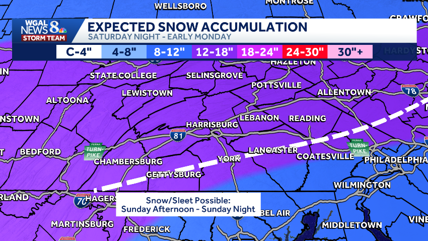
The WGAL News 8 Storm Team is tracking a big storm expected to bring 12 to 18 inches of snow to south-central Pennsylvania this weekend.
The National Weather Service issued a Winter Storm Watch for the entire Susquehanna Valley from 10 p.m. Saturday to 1 p.m. Monday. This could be upgraded to a Winter Storm Warning.

What to know Friday is an Impact Night starting at 6 p.m. as wind chills drop below zero. Saturday is an Impact Day for sub-zero wind chills in the morning and single-digit wind chills in the afternoon. Sunday is an Alert Day due to the potential for significant snowfall, meaning the day could feature the threat of extreme, severe and possibly life-threatening weather.Monday is also an Alert Day for blowing and drifting snow, dangerous wind chills, and hazardous travel conditions.

Totals: 12-18 inches expected
The storm is expected to bring about 12 to 18 inches of snow across most of the Susquehanna Valley.
Southern York and Lancaster counties could get about eight to 12 inches, depending on the chance of sleet Sunday evening.

TimingSnow will develop Saturday night, around midnight, and will be steadily snowing around sunrise on Sunday. It will be heavy at times, with one to two inches of snow an hour throughout the afternoon. Visibility will be poor. Warmer air will move into the low-levels of the atmosphere, and low pressure will move off the Delmarva coast. This will change snow to sleet in the southeastern counties late Sunday. The WGAL Storm Team is closely tracking this line, as it could cut down snow totals. After the storm, winds will increase on Monday, causing blowing and drifting snow.


Impacts after the storm Stronger winds and lingering Arctic air will bring dangerous, bone-chilling cold after the storm.Blowing and drifting snow will create hazardous travel, especially on Monday. Expect snow-covered and slick roads, especially on untreated areas. Strong winds could lead to scattered power outages.


Live weather coverage
With all eyes on this weekend’s storm, the News 8 Today team has you covered. We’ll have live team coverage from 6 a.m. to 9 a.m. Sunday morning, plus a special livestream newscast at noon. Watch on WGAL.com and the Very Local app.
WGAL Weather Toolkit