
Western PA: Alert Days for frigid wind chills, major snowstorm
Snow arrives Saturday night and will continue through Monday morning.
PITTSBURGH’S ACTION SPORTS. PITTSBURGH’S ACTION SPORTS TWO. PITTSBURGH’S ACTION WEATHER REALLY THE MAIN STORY OF THIS WEEKEND. AND WE’VE BEEN TALKING ABOUT IT FOR A WHILE. UNFORTUNATELY, IT IS TIME, RIGHT. IT’S UPON US. IN THE NEXT 24 HOURS, SNOW WILL BE FALLING AND MORE THAN LIKELY SEVERAL INCHES ALREADY ON THE GROUND. BY THIS TIME TOMORROW. AND THAT WILL JUST BE THE BEGINNING OF THE SNOWSTORM. BEFORE WE GET GOING, THOUGH, WE’RE DEALING WITH THOSE EXTREMELY COLD WIND CHILLS THIS MORNING ARE HOVERING AROUND ZERO EVEN AS WE HEAD INTO THIS AFTERNOON. THEN THE SNOW KICKS IN LATER ON TONIGHT. LAST ALL DAY LONG. TOMORROW WILL BE HEAVY AT TIMES BEFORE EVENTUALLY THINGS WILL WRAP UP EARLY IN THE DAY. ON MONDAY IT FEELS LIKE NINE BELOW RIGHT NOW IN PITTSBURGH. ELSEWHERE, THOSE WIND CHILLS CLOSER TO ZERO AS WE WILL SEE THE COLD WEATHER ADVISORY EXPIRE. FOR THOSE OF YOU INTO THE LAUREL HIGHLANDS AS WE HIT THE TOP OF THE 10:00 HOUR, BUT IT STAYS FRIGID ALL DAY LONG. AIR TEMPERATURES ONLY IN THE TEENS WON’T FEEL LIKE THAT AT ANY POINT. AS WE GO THROUGH THE AFTERNOON WITH THOSE WIND CHILL NUMBERS STILL HOVERING CLOSE TO ZERO ALL DAY LONG. STARTING AT 7:00 TONIGHT, WINTER STORM WARNING IS OUT AND THAT WILL EXTEND THROUGH NOON ON MONDAY. SO SHOWS YOU THE TIMELINE OF THE SIGNIFICANT SNOWSTORM THAT IS GOING TO BE COMING IN. BIGGEST ONE THAT WE HAVE SEEN IN QUITE SOME TIME NOW. THE TYPE OF SNOW WE GET IS ALL GOING TO BE LOCATION DEPENDENT. IT’S GOING TO BE LIGHT AND FLUFFY, A LITTLE BIT DRIER SNOW, ESPECIALLY FOR THOSE OF YOU NORTH OF THE CITY. BUT THEN AS YOU GET CLOSER TO ALLEGHENY COUNTY, WE’LL START OFF FLUFFY BUT EVENTUALLY GET TO THAT HEAVIER, WET SNOW THAT’S A LITTLE BIT MORE DENSE, HARDER TO PUSH AND CLEAR OFF OF THE SIDEWALK AS WE APPROACH MIDDAY. LASTING THROUGH THE SECOND HALF OF THE STORM. MEANWHILE, THAT SNOW IS GOING TO BE A WHOLE LOT BETTER. MUCH BETTER FOR MAKING SNOW MEN. FOR THOSE OF YOU CLOSER TO THE WEST VIRGINIA BORDER, WE’LL TALK MORE ABOUT JUST HOW MUCH OF THAT SNOW MAKING SNOW YOU’LL GET HERE IN JUST A MOMENT. BUT LET’S TALK ABOUT THE TIMELINE OF THIS STORM. THINGS WILL GET GOING AS WE GET CLOSER TO MIDNIGHT. FIRST, FOR THOSE OF YOU CLOSE TO THE WEST VIRGINIA BORDER IN SOUTH OF I-70, THAT SNOW CONTINUES TO BUILD FROM SOUTH TO NORTH. AS YOU’RE WAKING UP TOMORROW, WHETHER YOU’RE GOING TO BE AN EARLY BIRD JOURNEY. JOINING US AT 5 A.M. OR AT ANY POINT THROUGH THE MORNING, SNOW WILL BE FLYING. COULD BE HEAVY AT TIMES AS WELL. TALKING ABOUT SNOWFALL RATES WITH SOME OF THOSE HEAVIER BANDS BETWEEN 1 AND 2IN PER HOUR. AGAIN, THIS HAS BEEN THE COMPLICATING FACTOR WITH THIS STORM. THIS A LITTLE BIT OF A WARM EDGE, STARTS TO BUILD IN AROUND MIDDAY. THAT WILL BRING A PERIOD OF SOME FREEZING RAIN AND SLEET TO THOSE OF YOU IN NORTHERN WEST VIRGINIA, POSSIBLY EVEN COULD PUSH CLOSER TO I-79 IN GREENE COUNTY. ALSO, MOST OF FAYETTE, EVEN PARTS OF WESTMORELAND COUNTY TOO. SO YOU WILL GET THAT ICY CHUNK OF ACCUMULATION OF THAT SLEET AND FREEZING RAIN ON TOP OF THE SNOW IN THE MORNING. WE WILL ADD MORE SNOW ON TOP OF THAT, AS THINGS WILL CONTINUE TO PILE ON AS WE GO THROUGH THE AFTERNOON. AS WE LOOK AHEAD TO EARLY MONDAY, SNOW IS GOING TO BE FLYING STILL AROUND THE MIDNIGHT HOUR BEFORE IT EVENTUALLY STARTS TO SHUT OFF. AS WE LOOK TOWARDS THE TYPICAL MONDAY MORNING COMMUTE TIME FRAME. AS YOU GET THE DAY STARTED TOMORROW, THIS IS 7:00 IN THE MORNING ALREADY. SOMEWHERE BETWEEN 1 AND 4IN OF SNOW WILL BE ON THE GROUND PRETTY QUICKLY. THAT SNOW IS GOING TO PILE UP AND ACCUMULATE RAPIDLY AGAIN, WITH THOSE HEAVIER BURSTS OF SNOW, THOSE SNOW BANDS WILL BE SHOWING UP AS WE GO THROUGH THE DAYLIGHT HOURS. THAT’S WHERE WE COULD EASILY GET THAT 8 TO 12IN OF SNOW. AND AGAIN, THAT’S JUST DURING THE DAYLIGHT HOURS. WE’LL TACK ON MAYBE 1 TO 3 MORE INCHES OF SNOW BEFORE THINGS ARE ALL SAID AND DONE BY MONDAY. SO WE ARE TALKING ABOUT, IN MOST NEIGHBORHOODS, A FOOT OR MORE OF SNOW BEFORE THINGS ARE ALL SAID AND DONE BY MONDAY. AS LOOK AT YOUR 4-DAY PLUS 4 MORE FORECAST. THE COLD IS HERE TO STAY 24 TOMORROW, BUT THEN WE SLIDE BACK INTO THE TEENS MONDAY. I’VE ADDED AN IMPACT DAY TO TUESDAY. THAT’S FOR THESE BITING WIND CHILLS THAT WILL CONTINUE, ESPECIALLY DURING THE MORNING HOURS. COULD BE TALKING ABOUT THOSE FEELS ANYWHERE FROM 20 TO EVEN 30 DEGREES BELOW ZERO. WE MAY NEED TO UPGRADE THAT TO AN ALERT DAY AS WELL. DOESN’T GET MUCH BETTER NEXT WEEK. LOW TEMPERATURES STILL CLOSE TO ZERO, AND THAT AGAIN DOESN’T ACCOUNT FOR THE WIND. HIGHS ONLY IN THE TEENS. MAYBE GETTING CLOSE TO 20 BY THIS TIME NEXT WEEKEND. BUT THAT COLD AIR IT IS STICKING AROUND THROUGH AT LEAST THE END OF JANUARY COULD SPILL OVER INTO THE START OF FEBRUARY TOO, BUT AT LEAST CONDITIONS ARE QUIETER. SECOND HALF OF NEXT WEEK. WE’RE STILL GOING TO HAVE OUR FAIR SHARE OF SNOW COMING IN TOMORROW. UNFORTUNATELY, THOUGH, YOU KNOW, WE’VE BEEN SAYING ALL MORNING THIS IS A TIME TO CHECK ON YOUR NEIGHBORS THAT KINDNESS WILL HAVE TO CONTINUE WELL INTO THE WEEK. IT’S GOING TO TAKE SOME TIME FOR THOSE ALL THE STREETS TO BE CLEARED. MAKE SURE THE SNOW IS MOVING OUT SO THAT WE CAN BE SAFE, SO WE MAY BE EXTENDING OUR SNOW DAY INTO MONDAY, IF NOT FARTHER THAN THAT DOWN THE LINE AS WE CONTINUE TO CLEAN UP. WE APPRECIATE ALL OF YOUR UPDATES. WE KNOW YOU WILL
Western PA: Alert Days for frigid wind chills, major snowstorm
Snow arrives Saturday night and will continue through Monday morning.

Updated: 10:18 AM EST Jan 24, 2026
This weekend is a double whammy of winter weather. First, sub-zero wind chills today. Next is the major snow storm that will begin overnight and last through Monday morning.Alert Day for the extreme coldSaturday is a Severe Weather Alert Day as we see another round of brutal cold. Wake-up temperatures will be near 0° with wind chills between -10° and -20° for most of Western Pennsylvania. Temperatures and wind chills will barely improve and hover only around zero as we head through the day. Outside of the frigid air, conditions will remain quiet and dry for your last minute trips to the store. The snow will arrive tonight.Winter Storm Warning – Sunday snowstormA Winter Storm Warning has been issued for all of Western PA from 7 p.m. Saturday through noon Monday.Tomorrow is also a Severe Weather Alert Day for snow. The storm will approach from the south with the snow starting tonight. Models are remain in agreement that the “brunt” of the storm will be during the day on Sunday. Snow could pile up at rates of one to two inches per hour. The heaviest snow will taper off Sunday evening. The storm will finally end Monday morning.Significant snow is anticipated across the region. The forecast holds with 8-12 inches of snow to fall by the end of Sunday for most of Western Pennsylvania. We could tack on an additional one to three inches through Monday morning.Our one question left today is does enough warm air make it north into our area to allow for a period of sleet and/or freezing rain south of Interstate 70 and into the Laurel Highlands. If it does, this will limit snow totals here but add icing concerns.Prolonged cold next weekAfter the snow ends, we will see a prolonged period of cold. Tuesday is now an Impact Day for sub-zero wind chills, especially in the morning. The frigid air will keep morning temperatures in the single digits to around zero, and highs in the teens all week long. Substantial river icing is likely by the middle of next week.SATURDAY – Severe Weather Alert Day: Dangerous cold with subzero wind chills. High: 14°.TONIGHT – Severe Weather Alert Day: Snow arrives after midnight, low: 10°.SUNDAY – Severe Weather Alert Day: A significant amount of snow. High: 24°, low: 14°.MONDAY – Severe Weather Alert Day: Morning snow then cold. High: 18°, low: 0°.TUESDAY – Impact Day: Subzero wind chills in the morning, partly cloudy and very cold. High: 16°, low: 3°.
PITTSBURGH —
This weekend is a double whammy of winter weather. First, sub-zero wind chills today. Next is the major snow storm that will begin overnight and last through Monday morning.
Alert Day for the extreme cold
Saturday is a Severe Weather Alert Day as we see another round of brutal cold. Wake-up temperatures will be near 0° with wind chills between -10° and -20° for most of Western Pennsylvania. Temperatures and wind chills will barely improve and hover only around zero as we head through the day.

Hearst OwnedHearst
Wind chills only “improve” close to zero this afternoon.
Outside of the frigid air, conditions will remain quiet and dry for your last minute trips to the store. The snow will arrive tonight.
Winter Storm Warning – Sunday snowstorm
A Winter Storm Warning has been issued for all of Western PA from 7 p.m. Saturday through noon Monday.

Hearst OwnedHearst
The Winter Storm Warming for all of western PA takes us through noon on Monday.
Tomorrow is also a Severe Weather Alert Day for snow. The storm will approach from the south with the snow starting tonight. Models are remain in agreement that the “brunt” of the storm will be during the day on Sunday. Snow could pile up at rates of one to two inches per hour. The heaviest snow will taper off Sunday evening. The storm will finally end Monday morning.
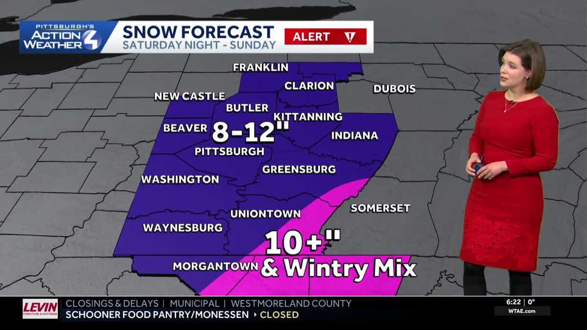
Significant snow is anticipated across the region. The forecast holds with 8-12 inches of snow to fall by the end of Sunday for most of Western Pennsylvania. We could tack on an additional one to three inches through Monday morning.

Hearst Owned
The snow total forecast holds with most of western PA picking up between 8 inches and a foot by late Sunday. Additional light accumulations arrive Monday morning.
Our one question left today is does enough warm air make it north into our area to allow for a period of sleet and/or freezing rain south of Interstate 70 and into the Laurel Highlands. If it does, this will limit snow totals here but add icing concerns.
Prolonged cold next week
After the snow ends, we will see a prolonged period of cold. Tuesday is now an Impact Day for sub-zero wind chills, especially in the morning. The frigid air will keep morning temperatures in the single digits to around zero, and highs in the teens all week long. Substantial river icing is likely by the middle of next week.

Hearst OwnedHearst
There is no shaking the bitter cold next week.
SATURDAY – Severe Weather Alert Day: Dangerous cold with subzero wind chills. High: 14°.
TONIGHT – Severe Weather Alert Day: Snow arrives after midnight, low: 10°.
SUNDAY – Severe Weather Alert Day: A significant amount of snow. High: 24°, low: 14°.
MONDAY – Severe Weather Alert Day: Morning snow then cold. High: 18°, low: 0°.
TUESDAY – Impact Day: Subzero wind chills in the morning, partly cloudy and very cold. High: 16°, low: 3°.