
NEW HOUR-BY-HOUR: Snow falls 1-2 inches per hour in south-central Pennsylvania
MARYELLEN PANN. THANK YOU BOTH FOR BEING HERE THIS MORNING. LET’S GO RIGHT OVER TO METEOROLOGIST. YEAH. SO DRIVING IN ABOUT 1 A.M. THIS MORNING, THE SNOW STARTED OUT VERY SCATTERED AND LIGHT IN NATURE. BUT NOW PICKING UP AND MOVING ACROSS THE AREA AND EVEN HAVE SOME MODERATE SNOW FALLING IN PARTS. AND YOU WERE TALKING ABOUT YOU STEPPED OUTSIDE. IT WAS LIKE THE FINE AND POWDERY, YOU KNOW, VERY SPARKLY SNOW IS JUST FALLING EXTREMELY LIGHTLY. THE AIR IS DRY. SO THAT’S WHAT WE’RE GOING TO BE SEEING TODAY. THIS VERY FLUFFY, POWDERY SNOW. AND IT’S ACCUMULATING QUICKLY ALREADY. I THINK WE SOME PLACES MAYBE EVEN HAVE CLOSING IN ON TWO INCHES. I WOULDN’T BE SHOCKED TO SEE THAT. AND THIS IS JUST THE BEGINNING. SO LET’S TAKE A LOOK AT OUR STORM TEAM LIVE RADAR NETWORK AND TAKE YOU AROUND THE AREA AND SHOW YOU THE BRIGHTER WHITES INDICATING WHERE IT’S COMING DOWN A LITTLE BIT MORE MODERATELY. WHEN YOU START TO SEE THE GRAY COLOR OR THE BLUE COLOR, THAT’S WHERE IT IS LIGHT IN NATURE. SO ZOOMING INTO CHAMBERSBURG, GETTYSBURG, BENDERSVILLE AND ADAMS COUNTY, YOU’RE SEEING SOME MODERATE LIGHT TO MODERATE SNOW FALLING HERE. WE’VE GOT LIGHT TO MODERATE SNOW FROM HARRISBURG OVER TOWARDS PORT ROYAL. UP THERE IN JUNIATA COUNTY HEADING OVER TO HERSHEY, LEBANON, MANHEIM AND INTO LANCASTER. LIGHT TO MODERATE SNOW CONTINUING TO FALL. IT’S A LITTLE LIGHTER TO THE SOUTH ACROSS FAWN GROVE, DELTA AND SHREWSBURY, RIGHT THERE ALONG I-83. BUT LOOK HOW MASSIVE THIS STORM IS. I MEAN, IT EXTENDS ALL THE WAY BACK INTO TEXAS. WE’RE TALKING ABOUT SNOW, FREEZING RAIN, SLEET, A LOT OF MOISTURE MOVING FROM SOUTHWEST TO NORTHEAST INTO THE AREA. SO BECAUSE OF THIS MASSIVE STORM AND THE POTENTIAL FOR SEVERAL INCHES OF SNOW ACCUMULATIONS, WE HAVE A WINTER STORM WARNING IN EFFECT AND THAT GOES UNTIL 1 P.M. TOMORROW. IT’S GOING TO BE A LONG DURATION STORM. AND LET ME SHOW YOU OUR SNOW TOTALS. HERE. WE HAVE THAT PURPLE SHADED AREA WHERE YOU CAN SEE 12 TO 18IN OF SNOW. THE DOTTED WHITE LINE IS WHERE SLEET WILL REACH, SO IT WILL GRADUALLY MOVE IN THIS AFTERNOON FROM SOUTH TO NORTH. I THINK I 81 IS A GOOD STOPPING LINE FOR THAT SLEET NOW BECAUSE OF THE MIX TO SLEET IN THE AFTERNOON WE HAVE LANCASTER, YORK, ADAMS AND PARTS OF FRANKLIN COUNTY IN OUR 8 TO 12 INCH ZONE. BUT REMEMBER YOU COULD GET SNOW PLUS AN INCH OR TWO OF SLEET, SO THAT IS STILL GOING TO MAKE THINGS QUITE DANGEROUS. RIGHT NOW, TEMPERATURES ARE IN THE TEENS RIGHT AROUND TEN, IN FACT, AND OUR WIND CHILLS ARE SUBZERO. SO IF YOU ARE HEADED OUT TO SHOVEL, PLEASE USE EXTREME CAUTION. MAKE SURE YOU’RE WELL BUNDLED UP. SO WIDESPREAD SNOW FROM NOW TO NOON. HEAVY SNOW THIS AFTERNOON WITH THAT SLEET LINE MOVING NORTH AS WE HEAD TOWARD EVENING. SNOW WILL TAPER AND TOMORROW WE’RE GOING TO TALK ABOUT BLOWING
NEW HOUR-BY-HOUR: Snow falls 1-2 inches per hour in south-central Pennsylvania

Updated: 6:23 AM EST Jan 25, 2026
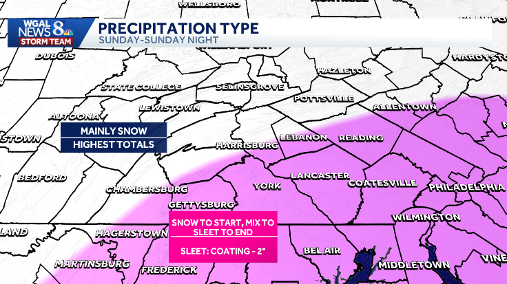
A major winter storm has arrived in south-central Pennsylvania, with one to two inches of snow accumulating per hour. The National Weather Service issued a Winter Storm Warning, which is in effect until 1 p.m. Monday. Hour-by-hour After midnight: Snow developed, arrived in Pennsylvania and is moving south to north. Sunday morning: Peak timing for the heaviest snow and worst conditions into early afternoon. Peak snowfall rates: 1-2 inches per hour. Sunday afternoon into evening: Sleet mixes in, mainly southern and southeastern counties (which could cut totals)Late Sunday night: Most precipitation tapers offSnow TotalsMost areas: About 12 inches Southern Lancaster & York Counties: 8–12 inchesImpactsMonday impacts (after snow ends): Northwest winds 15–25 mph could cause blowing and drifting snow, reducing visibility.Travel impacts: Hazardous and dangerous travel during the heaviest snow, with poor visibility, delays or closures, and possible power outages.After the storm: Bitter cold arrives next week—highs in the low 20s, lows in the single digits, and sub-zero wind chills likely on many nights. Do you have photos or videos of the snowstorm? Send them to WGAL News 8 at https://www.wgal.com/upload. Be sure to include where the image was captured.SOUTH-CENTRAL PA WEATHER RESOURCES: INTERACTIVE RADAR | ACTIVE WEATHER ALERTS | CURRENT CONDITIONS | HOURLY FORECAST | 10-DAY FORECAST | WEEKEND FORECAST | MAP ROOM | DOWNLOAD THE APP | WEATHER EMAILS
A major winter storm has arrived in south-central Pennsylvania, with one to two inches of snow accumulating per hour.
The National Weather Service issued a Winter Storm Warning, which is in effect until 1 p.m. Monday.
Hour-by-hour After midnight: Snow developed, arrived in Pennsylvania and is moving south to north. Sunday morning: Peak timing for the heaviest snow and worst conditions into early afternoon. Peak snowfall rates: 1-2 inches per hour. Sunday afternoon into evening: Sleet mixes in, mainly southern and southeastern counties (which could cut totals)Late Sunday night: Most precipitation tapers off


Snow Totals
Most areas: About 12 inches Southern Lancaster & York Counties: 8–12 inches


Impacts
Monday impacts (after snow ends): Northwest winds 15–25 mph could cause blowing and drifting snow, reducing visibility.
Travel impacts: Hazardous and dangerous travel during the heaviest snow, with poor visibility, delays or closures, and possible power outages.
After the storm: Bitter cold arrives next week—highs in the low 20s, lows in the single digits, and sub-zero wind chills likely on many nights.


Do you have photos or videos of the snowstorm? Send them to WGAL News 8 at https://www.wgal.com/upload. Be sure to include where the image was captured.
SOUTH-CENTRAL PA WEATHER RESOURCES: INTERACTIVE RADAR | ACTIVE WEATHER ALERTS | CURRENT CONDITIONS | HOURLY FORECAST | 10-DAY FORECAST | WEEKEND FORECAST | MAP ROOM | DOWNLOAD THE APP | WEATHER EMAILS