
LET’S GO RIGHT OVER TO THE METEOROLOGIST IN THE HOUSE. GOOD MORNING EVERYONE. IT HAS BEEN QUITE A STORM. IT CERTAINLY HAS A VERY COMPLEX STORM. WE HAD FREEZING RAIN AND SLEET AND WE HAD SNOW. AND I’LL EXPLAIN WHY WE SAW THOSE THREE TYPES OF PRECIPITATION WITH YESTERDAY’S STORM. AND NOW AS WE MOVE FORWARD, WE’RE GOING TO BE LOOKING AT BLOWING AND DRIFTING SNOW BEING OUR MAIN CONCERN TODAY. THE STORM HAS MOVED OUT. YOU SEE IT IS DRY ON OUR STORM TEAM LIVE RADAR NETWORK AND IT’S MOSTLY CLOUDY RIGHT NOW. THAT’S HELPING TO KEEP OUR TEMPERATURES UP. IT’S 19 IN LEBANON, 15 IN YORK, 17 IN CHAMBERSBURG, AND THESE NUMBERS ARE GOING TO BE WARM COMPARED TO THE NUMBERS YOU’LL SEE IN THE MORNINGS OVER THE NEXT COUPLE OF DAYS. FEELS LIKE TEMPERATURES, WIND HAVING VERY LITTLE IMPACT THIS MORNING. BUT IT WILL HAVE A GREATER IMPACT ONCE WE HIT THE AFTERNOON 12 HOUR FORECAST. TODAY WE CONTINUE OUR ALERT DAY BECAUSE OF THE BLOWING AND DRIFTING SNOW POTENTIAL. IN ADDITION, THE HAZARDOUS ROAD CONDITIONS STILL AROUND IN MANY AREAS ACROSS THE SUSQUEHANNA VALLEY THIS MORNING. NOW WE WILL GET TO THE 20S THIS AFTERNOON. I DO SEE SOME CLEARING, SO THAT’S GOOD NEWS, BUT IT JUST GETS DOWNRIGHT COLD TONIGHT. SO IF YOU CAN CLEAR YOUR SIDEWALKS, IN YOUR DRIVEWAYS AND MAYBE A LITTLE BIT OF SUN WILL HELP US OUT THIS AFTERNOON, DO THAT TODAY BECAUSE WE ARE UNDER A COLD WEATHER ADVISORY TONIGHT AND OVERNIGHT WIND CHILLS. THEY COULD BE SUBZERO WELL BELOW ZERO. WE’
AFTER THE STORM: Blustery winds to cause blowing, drifting snow across south-central Pennsylvania

Updated: 4:14 AM EST Jan 26, 2026
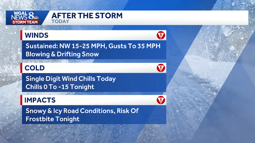
Although the winter storm has moved out of south-central Pennsylvania, blustery winds are kicking up, blowing and drifting snow, creating hazardous road conditions across the region. Monday is an Alert Day, meaning the day features the threat of extreme, severe, and possibly life-threatening weather. The National Weather Service has issued a cold weather advisory for the entire Susquehanna Valley, in effect from 7 p.m. Monday through 10 a.m. Tuesday. Sub-zero wind chillsWinds increase: Sustained 15-25 mph winds with gusts up to 40 mph. Temperatures: Highs in the low 20s with a mix of clouds and sunshine across the region. Wind chills: Single digits during the day, making it feel much colder. Heading into the night: Winds diminish, but temperatures drop to near zero with wind chills below zero. Blowing, drifting snowTravel impacts: The gusty winds will cause blowing and drifting snow, leading to dangerous road conditions. Slick roads: Drivers are reminded to be alert and cautious as some roads remain very slick and icy, especially on untreated areas. Speed limit restrictions: PennDOT reduced the speed limit and implemented traffic restrictions on major highways across the Susquehanna Valley. Closings, delaysHundreds of schools, businesses and other organizations have announced closings and delays following Sunday’s winter storm. View the full list here. WGAL weather linksWatch it: Use WGAL’s interactive radar to track storms.Get alerts that follow you: Turn on location-based weather alerts with WGAL’s step-by-step instructions.Check what’s closed: See closings and delays for businesses, churches, and organizations during severe weather.Navigate smarter: Open WGAL’s interactive traffic map for crashes, construction, and road closures—with traffic cameras.Inbox updates: Sign up for email alerts, from daily forecasts to severe-weather warnings.Plan by the hour: View the hour-by-hour forecast for your day.Weekend ready: Preview the weekend forecast before you lock in plans.Look ahead: Browse the 10-day forecast for the extended outlook.
Although the winter storm has moved out of south-central Pennsylvania, blustery winds are kicking up, blowing and drifting snow, creating hazardous road conditions across the region.
Monday is an Alert Day, meaning the day features the threat of extreme, severe, and possibly life-threatening weather.
The National Weather Service has issued a cold weather advisory for the entire Susquehanna Valley, in effect from 7 p.m. Monday through 10 a.m. Tuesday.

Sub-zero wind chills
Winds increase: Sustained 15-25 mph winds with gusts up to 40 mph.
Temperatures: Highs in the low 20s with a mix of clouds and sunshine across the region.
Wind chills: Single digits during the day, making it feel much colder.
Heading into the night: Winds diminish, but temperatures drop to near zero with wind chills below zero.

Blowing, drifting snow
Travel impacts: The gusty winds will cause blowing and drifting snow, leading to dangerous road conditions.
Slick roads: Drivers are reminded to be alert and cautious as some roads remain very slick and icy, especially on untreated areas.
Speed limit restrictions: PennDOT reduced the speed limit and implemented traffic restrictions on major highways across the Susquehanna Valley.


Closings, delays
Hundreds of schools, businesses and other organizations have announced closings and delays following Sunday’s winter storm.
View the full list here.
WGAL weather links