
The snow may be over, but the cold stretch is not! January ends on a frigid note with temperatures staying well below freezing all week long. Today and Tuesday are Alert Day; Impact Days for Wednesday and Thursday.Lingering snow showersThe Winter Storm Warning remains in effect for all of us until noon. Roads are still snow covered and may not have been plowed in several hours.The steady accumulating snow has ended. Additional light snow showers and flurries are possible this morning. The ridges could enhance some of this snowfall out east. The flakes will shut off around mid-day for most of western Pennsylvania. We could see a couple more inches of snow on top of what fell yesterday. But, for the most part, any extra snow will go unnoticed.Alert Days: Frigid air and brutal wind chillsIt is another bitterly cold day. Wind chills will hover around zero as you continue digging out from the snowstorm. Gusts up to 25 mph are expected this afternoon, which will blow around the powdery top layer of snow.The entire area will go under an Extreme Cold Warning between 7 p.m. and 11 a.m. Tuesday. Tomorrow will be the coldest feeling morning of this stretch of Arctic air. The Alert Days extend into Tuesday. Wind chills could dip as low as 25 degrees below zero overnight. For the higher elevations east, reading will go as low as -30°. Frostbite can occur in as little as 30 minutes on exposed skin. The feels like temperatures will remain sub-zero for most of the day.Plenty of very cold air to end JanuaryTo put it plainly, there really is no end in sight to this brutally cold stretch. The Arctic air will keep morning temperatures in the single digits to around zero and highs in the teens all week long. Wednesday and Thursday are Impact Days. There is a chance for flurries tomorrow and Wednesday. Little, if any, accumulation with these passing flakes. The pattern will trend quieter through the weekend. High temperatures will bust into the 20s over the weekend.TODAY – Severe Weather Alert Day: Morning flurries and light snow showers. Very cold with single digit wind chills. High: 18°.TONIGHT – Severe Weather Alert Day: Partly to mostly cloudy. Wind chills as low as -15° to -30°. Low: 0°.TUESDAY – Severe Weather Alert Day: Sub-zero wind chills all day long. Mostly cloudy with passing flurries. High: 16°, low: 3°.WEDNESDAY – Impact Day: Mostly cloudy with flurries. High: 14°, low: 1°.THURSDAY – Impact Day: Limited sunshine and very cold. High: 15°, low: 0°.
PITTSBURGH —
The snow may be over, but the cold stretch is not! January ends on a frigid note with temperatures staying well below freezing all week long. Today and Tuesday are Alert Day; Impact Days for Wednesday and Thursday.
Lingering snow showers
The Winter Storm Warning remains in effect for all of us until noon. Roads are still snow covered and may not have been plowed in several hours.
The steady accumulating snow has ended. Additional light snow showers and flurries are possible this morning. The ridges could enhance some of this snowfall out east. The flakes will shut off around mid-day for most of western Pennsylvania. We could see a couple more inches of snow on top of what fell yesterday. But, for the most part, any extra snow will go unnoticed.

Hearst OwnedHearst
Scattered flurries and light snow continue today. The Laurels could pick up a few extra inches of accumulation.
Alert Days: Frigid air and brutal wind chills
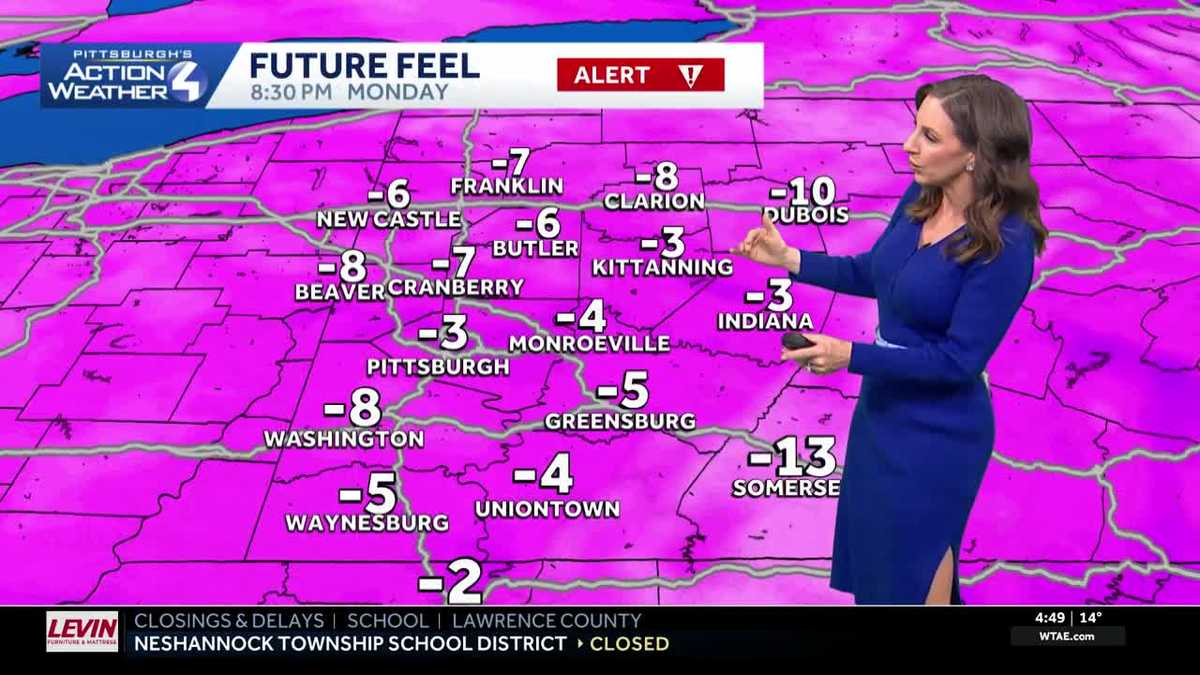
It is another bitterly cold day. Wind chills will hover around zero as you continue digging out from the snowstorm. Gusts up to 25 mph are expected this afternoon, which will blow around the powdery top layer of snow.

Hearst OwnedHearst
An Extreme Cold Warning for all of western PA through late Tuesday morning.
The entire area will go under an Extreme Cold Warning between 7 p.m. and 11 a.m. Tuesday. Tomorrow will be the coldest feeling morning of this stretch of Arctic air. The Alert Days extend into Tuesday. Wind chills could dip as low as 25 degrees below zero overnight. For the higher elevations east, reading will go as low as -30°. Frostbite can occur in as little as 30 minutes on exposed skin. The feels like temperatures will remain sub-zero for most of the day.

Hearst OwnedHearst
Tuesday morning will be the coldest feeling morning of this Arctic stretch.
Plenty of very cold air to end January
To put it plainly, there really is no end in sight to this brutally cold stretch. The Arctic air will keep morning temperatures in the single digits to around zero and highs in the teens all week long. Wednesday and Thursday are Impact Days.
There is a chance for flurries tomorrow and Wednesday. Little, if any, accumulation with these passing flakes. The pattern will trend quieter through the weekend. High temperatures will bust into the 20s over the weekend.

Hearst OwnedHearst
It is a frigid week ahead with lows near zero and highs in the teens.
TODAY – Severe Weather Alert Day: Morning flurries and light snow showers. Very cold with single digit wind chills. High: 18°.
TONIGHT – Severe Weather Alert Day: Partly to mostly cloudy. Wind chills as low as -15° to -30°. Low: 0°.
TUESDAY – Severe Weather Alert Day: Sub-zero wind chills all day long. Mostly cloudy with passing flurries. High: 16°, low: 3°.
WEDNESDAY – Impact Day: Mostly cloudy with flurries. High: 14°, low: 1°.
THURSDAY – Impact Day: Limited sunshine and very cold. High: 15°, low: 0°.