
Major nor’easter expected to stay off shore for now
FLYING RIGHT THROUGH THE SUSQUEHANNA VALLEY MIDDAY. AND THEN THEY’RE OUT OF HERE BY EVENING. THAT SYSTEM PASSES OVERNIGHT. THE SKY CLEARS AND SETS US UP ONCE AGAIN FOR VERY COLD TEMPERATURES AND SUBZERO WIND CHILLS. TOMORROW MORNING WE SEE A FEW CLOUDS PASSING BY. TOMORROW AFTERNOON GET THE SAME FORECAST ON THURSDAY WITH MORNING SUN, AFTERNOON CLOUDS, TEMPERATURES NEAR 20 AND SUBZERO WIND CHILLS AT NIGHT. SO KIND OF A RINSE AND REPEAT. AS WE’VE BEEN SAYING. TAKE A LOOK AT THIS THING. THIS IS A MONSTER STORM, BUT IT IS OFF SHORE. SO IT MOVES OUT TO SEA AND DOESN’T REALLY BOTHER US AS WE HEAD INTO SATURDAY AND SUNDAY. THAT’S THE LATEST THINKING ON THE GUIDANCE. BUT LOOK, IT’S A CLOSE SHAVE, SO IT’S SOMETHING THAT WE’RE GOING TO BE WATCHING VERY CLOSELY OVER THE NEXT COUPLE OF DAYS TO SEE IF THERE ARE ANY POTENTIAL IMPACTS TO THE SUSQUEHANNA VALLEY FROM THIS STORM. THERE IS A HIGH LIKELIHOOD THAT THERE WILL BE A NOR’EASTER OUT TO SEA, BUT I DON’T THINK IT’S GOING TO IMPACT US. IT’S VERY LOW CHANCE RIGHT NOW THE WAY THINGS ARE LOOKING. SO WE’LL KEEP YOU UPDATED ON THAT. BUT NOTICE AS WE HEAD INTO THE WEEKEND, TEMPERATURES MODERATE A LITTLE BIT. NEXT WEEK WE SEE SOME IMPROVEMENTS WITH HIG
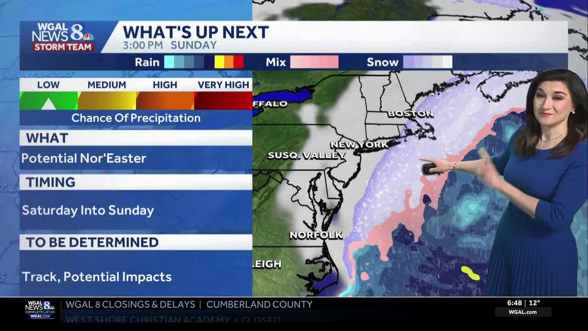
A major winter storm will stay well offshore and is expected to move out to sea, so South-Central Pennsylvania should largely avoid impacts through Saturday and Sunday.What to expect now through the weekendStorm will track offshore as a nor’easter — likely will stay out to sea.Susquehanna Valley: very low chance of direct impacts as of Tuesday.Close shave: the track is close enough that we’ll watch guidance closely over the next several days.Timing and chance of impactNow through Friday: energy for the storm moves from Canada to the southern U.S. – the WGAL News 8 Storm Team will monitor model updates.Saturday to Sunday: low pressure develops offshore. Most guidance keeps impacts away from South-Central Pennsylvania; plan for minimal disruption but stay alert for any track changes.Temperatures and next weekWeekend: temperatures moderate a bit compared with recent cold.Early next week (first days of February): highs at or just above freezing with improving conditions.
A major winter storm will stay well offshore and is expected to move out to sea, so South-Central Pennsylvania should largely avoid impacts through Saturday and Sunday.
What to expect now through the weekend
Storm will track offshore as a nor’easter — likely will stay out to sea.Susquehanna Valley: very low chance of direct impacts as of Tuesday.Close shave: the track is close enough that we’ll watch guidance closely over the next several days.Timing and chance of impactNow through Friday: energy for the storm moves from Canada to the southern U.S. – the WGAL News 8 Storm Team will monitor model updates.Saturday to Sunday: low pressure develops offshore. Most guidance keeps impacts away from South-Central Pennsylvania; plan for minimal disruption but stay alert for any track changes.Temperatures and next week
Weekend: temperatures moderate a bit compared with recent cold.Early next week (first days of February): highs at or just above freezing with improving conditions.