
Frigid Conditions Continue All Week In South Central Pennsylvania
We’re locked in a frigid stretch through the weekend, with little change day-to-day
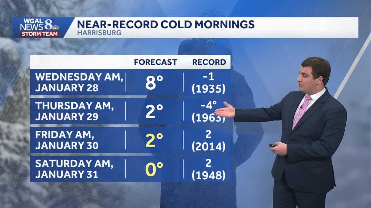
THESE MACHINES ON THE ROADS IN PENNSYLVANIA. NOW, THE WGAL NEWS EIGHT STORM TEAM FORECAST WITH METEOROLOGIST MIKE SUSKO. WELL GOOD AFTERNOON. THE SUBZERO WIND CHILLS WILL CONTINUE AS WE GO INTO TONIGHT. AND THEN SINGLE-DIGIT WIND CHILLS THROUGHOUT THE DAY AS THIS ARCTIC CHILL REMAINS ALL WEEK. AND WE WILL BE ABLE TO CHALLENGE SOME RECORD LOWS AT NIGHT. WE’RE ALSO WATCHING THE WEEKEND FOR A POSSIBLE CHANCE FOR SOME MORE SNOW ACROSS THE AREA, BUT IT’S NOT A GUARANTEE WE’LL TALK ABOUT THAT HERE IN JUST A MINUTE. BUT LEBANON RIGHT NOW, THE CLOUDS ARE IN PLACE. YOU MAY SEE A FEW FLURRIES AS WE GO THROUGH THE DAY TODAY. THEY’RE GOING TO BE HIT OR MISS AND SCATTERED ACROSS THE AREA, BUT IT’S COLD ENOUGH FOR SNOW, RIGHT? IT FEELS LIKE WE’RE IN THE SINGLE DIGITS. FEELS LIKE ONE DEGREE IN LEBANON, SEVEN IN HARRISBURG, AS WELL AS CHAMBERSBURG AND FOUR IN LEWISTOWN, AND JUST THREE IN LANCASTER. AS WE GO THROUGH THE REST OF THE DAY TODAY, HIGHS THEMSELVES AROUND 20 DEGREES, BUT THAT FEELS LIKE TEMPERATURE STAYING IN THE SINGLE DIGITS. AND THEN OVERNIGHT TONIGHT, YOU CAN ALREADY SEE BY 1:00 FEELING LIKE MINUS TWO ACROSS PARTS OF THE AREA. SO IT’S GOING TO BE ANOTHER COLD NIGHT TONIGHT. AND THIS IS GOING TO CONTINUE ALL THE WAY TO THROUGH THE REST OF THE WEEK. SO AT NIGHT -5 TO -15 FOR THOSE WIND CHILLS. AND THEN DURING THE DAY IT’S JUST GOING TO FEEL LIKE WHAT IT IS RIGHT NOW HERE. AND EVEN WITH A LITTLE BIT OF A WIND, IT’S ENOUGH. BECAUSE THOSE COLD TEMPERATURES THAT WE COULD BE SEEING, THOSE SINGLE DIGIT WIND CHILLS. SO WE STAY COLD TODAY. A FEW FLURRIES OVER THE NEXT COUPLE OF HOURS. NOT OUT OF THE QUESTION. IF YOU GET ENOUGH, YOU MAY GET A COATING, BUT THAT’S REALLY MUCH IT. AS WE GO THROUGH THE AFTERNOON TONIGHT. MOSTLY CLEAR. WIND CHILLS AGAIN, BACKING OFF TO THE MINUS FIVE -15 RANGE OVERNIGHT. SO MAKE SURE YOU BUNDLE UP AND THEN TOMORROW. VERY SIMILAR TO WHAT WE HAVE TODAY. JUST MORE SUNSHINE. PARTLY SUNNY HERE. TEMPERATURES AROUND 20 DEGREES. BUT IT’S GOING TO FEEL LIKE THE SINGLE DIGITS AGAIN OUT THERE TOMORROW. COLD WEATHER ADVISORY WILL GO INTO EFFECT AGAIN TONIGHT FROM 7 P.M. UNTIL 10 A.M. ON WEDNESDAY. FOR EVERYBODY HERE. THERE’S A FEW SNOW SHOWERS TRYING TO POP UP HERE ON THE RADAR, ALTHOUGH NOTHING IS REALLY REACHING THE GROUND. BUT AGAIN, LEBANON, LANCASTER COUNTY, MAYBE PARTS OF YORK COUNTY SEEING A FEW FLURRIES. SAME THING IN MIFFLIN AND JUNIATA COUNTY. AS THE SYSTEM CONTINUES TO MOVE ON THROUGH. BUT AS WE GO THROUGH THE REST OF THE DAY TODAY, IT’S JUST GOING TO BE A MIX OF SUN AND CLOUDS HERE AT TIMES ACROSS THE AREA. AND THEN TONIGHT IT CLEARS OUT AND THAT’S GOING TO HELP OUR TEMPERATURES DROP TOMORROW AGAIN, ANOTHER ROUND OF MIX OF SUN AND CLOUDS HERE BUT STAYS DRY FOR YOUR WEDNESDAY. JUST GOING TO BE CLOUDY ACROSS OR COLD ACROSS THE AREA. AND THURSDAY IT’S THE SAME STORY RIGHT? AND THEN WHEN WE LOOK AT THE MORNING LOWS, OUR BEST CHANCE TO CHALLENGE SOME RECORD LOWS LOOKS TO BE FRIDAY MORNING AND SATURDAY MORNING. BUT EVEN TONIGHT AND INTO THURSDAY MORNING, IT’S STILL COLD. IT’S JUST IT’S NOT GOING TO BE NEAR THAT RECORD. I DO WANT TO TALK ABOUT THE WEEKEND HERE QUICKLY, BECAUSE A LOT OF YOU BEEN ASKING ABOUT THIS ON SOCIAL MEDIA, THIS STORM SYSTEM COULD END UP IMPACTING PARTS OF OUR AREA, BUT THE TRACK ALSO COULD GO OUT TO SEA. THAT’S THE BIGGEST QUESTION RIGHT NOW. WILL THE STORM GET CLOSE ENOUGH FOR IMPACTS HERE IN THE SUSQUEHANNA VALLEY? SOME SAY YES, SOME SAY NO. SO IT’S NOT A GUARANTEE. BUT IF WE DO END UP GETTING SNOW, IT WOULD BE SATURDAY AND INTO SUNDAY THAT WE HAVE TO WATCH. SO WE ARE WATCHING FOR THE COAST FOR MAYBE SOME MORE SNOW THIS WEEKEND, BUT UNTIL THEN IT’S GOING TO BE COLD SO MAKE SURE YOU STAY BUNDLED UP. STAY WARM. IT’S NOT UNTIL NEXT WEEK AND EVEN TUESDAY OR WEDNESDAY OF NEXT WEEK. WE FINALLY GET TO 32 DEGREE
Frigid Conditions Continue All Week In South Central Pennsylvania
We’re locked in a frigid stretch through the weekend, with little change day-to-day

Updated: 1:15 PM EST Jan 27, 2026
Good afternoon,A few afternoon snow showers or flurries will move northwest to southeast as the clipper passes. If you see a snow shower, a quick coating is possible, but the chance is low. Highs will reach 20 degrees, and wind chills will stay in the single digits.Tonight, the sky will clear, and temperatures will drop to the single digits. Add a 5-15 mph breeze, and wind chills will fall below zero. A Cold Weather Advisory is in effect again from 7 p.m. Tuesday until 10 a.m. Wednesday.Winds will remain brisk on Wednesday and Thursday, at 5-15 mph. Highs will reach 20 degrees under a mix of clouds and sunshine.Friday morning’s low of 2 degrees could tie the record low of 2, set in 2014. The rest of the day will be dry and cold, with highs near 18.We’re watching a developing offshore low this weekend, which could bring snow to the Susquehanna Valley. Right now, most guidance keeps this system offshore, but it’s close. We’ll continue to monitor and post updates. Temperatures will hit the low 20s Saturday, then climb into the mid-20s Sunday.Next week, a quick-moving system could produce a few snow showers Tuesday into Wednesday. Temperatures may finally hit freezing for highs Tuesday and Wednesday!Have a great day!
Good afternoon,
A few afternoon snow showers or flurries will move northwest to southeast as the clipper passes. If you see a snow shower, a quick coating is possible, but the chance is low. Highs will reach 20 degrees, and wind chills will stay in the single digits.
Tonight, the sky will clear, and temperatures will drop to the single digits. Add a 5-15 mph breeze, and wind chills will fall below zero. A Cold Weather Advisory is in effect again from 7 p.m. Tuesday until 10 a.m. Wednesday.
Winds will remain brisk on Wednesday and Thursday, at 5-15 mph. Highs will reach 20 degrees under a mix of clouds and sunshine.
Friday morning’s low of 2 degrees could tie the record low of 2, set in 2014. The rest of the day will be dry and cold, with highs near 18.
We’re watching a developing offshore low this weekend, which could bring snow to the Susquehanna Valley. Right now, most guidance keeps this system offshore, but it’s close. We’ll continue to monitor and post updates. Temperatures will hit the low 20s Saturday, then climb into the mid-20s Sunday.
Next week, a quick-moving system could produce a few snow showers Tuesday into Wednesday. Temperatures may finally hit freezing for highs Tuesday and Wednesday!
Have a great day!