
Will a coastal storm bring snow to Pennsylvania?
AS YOU CAN SEE, SOME OF THE STREETS ARE STILL A LITTLE BIT SNOW COVERED. WELL, THE SNOW HAS MOVED OUT, BUT NOW THE COLD IS SETTLING IN FOR THE NEXT SEVERAL DAYS ACROSS THE SUSQUEHANNA VALLEY. WE’RE GOING TO CONTINUE WITH THESE SUBZERO WIND CHILLS AT NIGHT HERE AS WE GO THROUGH THE REST OF THE WEEK. WE’RE ALSO WATCHING A POTENTIAL COASTAL STORM FOR THE WEEKEND, BUT IT’S NOT A GUARANTEE. LET’S LOOK AT THE MODELS HERE. THE YELLOW IS THE EUROPEAN MODEL. THIS ONE IS TAKING IT FARTHER OUT TO SEA, MEANING THAT WE ACTUALLY MISS OUT COMPLETELY HERE IN THE SUSQUEHANNA VALLEY. BUT WHEN YOU LOOK AT THE AMERICAN MODEL, IT IS A LITTLE BIT CLOSER TO SHORE. IF THIS WAS TO HAPPEN. NOW WE’RE TALKING. ACCUMULATING SNOW IS A POSSIBILITY IN THE PARTS OF THE SUSQUEHANNA VALLEY HERE, ESPECIALLY IF IT MOVES EVEN FARTHER TO THE WEST. BUT WE’RE STILL 5 TO 7 DAYS OUT. THE TRACK IS NOW GOING TO START TO COME INTO MORE CLEAR PICTURE AS WE GO THROUGH THE NEXT 24 HOURS OR SO, AND THEN THAT’S WHEN YOU CAN START MAYBE BUILDING A PLAN IS THAT WHEN WE KNOW, OKAY, IS THIS ACTUALLY GOING TO HIT US OR NOT? RIGHT NOW THERE’S JUST TOO MUCH UNCERTAINTY WITH THIS SYSTEM. BUT WE WILL CONTINUE TO LET YOU KNOW ABOUT WHETHER OR NOT WE COULD SEE THAT NOR’EASTER.
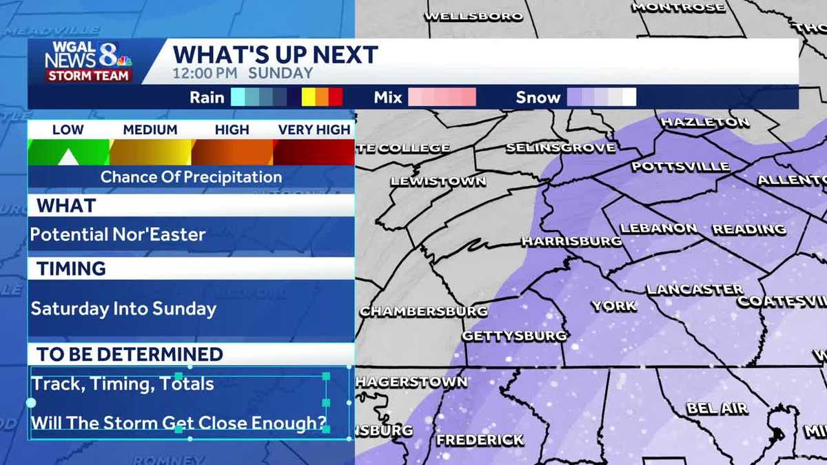
A potentially impactful coastal storm could affect South-Central Pennsylvania Saturday into Sunday, but model disagreement keeps confidence low right now.”We’re watching a potential coastal storm for the weekend, but it’s not a guarantee,” WGAL Meteorologist Mike Susko said.What the models showEuropean model: tracks the storm farther offshore — likely a miss for the Susquehanna Valley.American model: stays closer to shore — would bring the storm into range and raise the chance for accumulating snow.Small westward shifts in the track on model runs would increase snow chances across the valley.Potential impacts If the American solution verifies: accumulating snow is possible, with heavier amounts the farther west the track moves.If the European solution verifies: little to no impact in South-Central Pa.Timing and confidenceForecast window: Saturday into Sunday.Lead time: 5 to 7 days out now; confidence is low.Expect clearer model agreement in the next 24 to 48 hours.What to watch nextMonitor model trends over the next day — consistent westward shifts would raise the threat.Don’t finalize plans yet; check updated forecasts tomorrow for higher confidence and specifics on snow totals and timing.
A potentially impactful coastal storm could affect South-Central Pennsylvania Saturday into Sunday, but model disagreement keeps confidence low right now.
“We’re watching a potential coastal storm for the weekend, but it’s not a guarantee,” WGAL Meteorologist Mike Susko said.
What the models showEuropean model: tracks the storm farther offshore — likely a miss for the Susquehanna Valley.

American model: stays closer to shore — would bring the storm into range and raise the chance for accumulating snow.

Small westward shifts in the track on model runs would increase snow chances across the valley.

Potential impacts If the American solution verifies: accumulating snow is possible, with heavier amounts the farther west the track moves.If the European solution verifies: little to no impact in South-Central Pa.Timing and confidenceForecast window: Saturday into Sunday.Lead time: 5 to 7 days out now; confidence is low.Expect clearer model agreement in the next 24 to 48 hours.

What to watch nextMonitor model trends over the next day — consistent westward shifts would raise the threat.Don’t finalize plans yet; check updated forecasts tomorrow for higher confidence and specifics on snow totals and timing.

This content is imported from Woobox.
You may be able to find the same content in another format, or you may be able to find more information, at their web site.