
Conditions will be downright frigid this week, as western Pennsylvania continues to dig out from over a foot of snow in some areas.Wind chills could drop as low as -10 to -15 degrees on Wednesday morning. A cold weather advisory from the National Weather Service will be in effect from 7 p.m. Tuesday through 11 a.m. Wednesday.Impact Days: More cold and some sunshineWednesday and Thursday are Impact Days.High temperatures will be in the mid-teens with morning wind chills between -15 degrees and zero degrees.Clouds will hang tough with scattered flurries Wednesday, but Thursday should be a little brighter.Severe Weather Alert Days: Record lows possibleUnfortunately, this cold air is here to stay. The Arctic air will keep morning temperatures a couple degrees either side of zero and highs in the teens all week long.A fresh delivery of Arctic air arrives ahead of the weekend. We will go back to Severe Weather Alert Days for Friday and Saturday.Pittsburgh could challenge record low temperatures on Friday and Saturday. The record is -5 degrees for both days, set in 2019. Afternoon highs will only manage the lower teens.At this time, a weekend coastal storm looks to stay far enough east that the Pittsburgh area won’t see any impacts. We will continue to monitor the track. Temperatures will remain below freezing for early February. But instead of the teens, highs will be in the 20s.TUESDAY – Severe Weather Alert Day: Scattered light snow before midnight. Mostly cloudy with wind chills of 10 to 15 degrees below zero. Low: -1.WEDNESDAY – Impact Day: Mostly cloudy, blustery and very cold. High: 13, low: 2.THURSDAY – Impact Day: Bitterly cold with limited sunshine. High: 15, low: -7.
PITTSBURGH —
Conditions will be downright frigid this week, as western Pennsylvania continues to dig out from over a foot of snow in some areas.
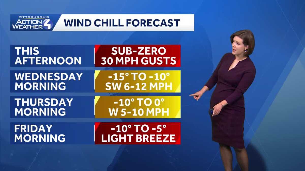
Wind chills could drop as low as -10 to -15 degrees on Wednesday morning. A cold weather advisory from the National Weather Service will be in effect from 7 p.m. Tuesday through 11 a.m. Wednesday.

Impact Days: More cold and some sunshine
Wednesday and Thursday are Impact Days.
High temperatures will be in the mid-teens with morning wind chills between -15 degrees and zero degrees.
Clouds will hang tough with scattered flurries Wednesday, but Thursday should be a little brighter.
Severe Weather Alert Days: Record lows possible
Unfortunately, this cold air is here to stay. The Arctic air will keep morning temperatures a couple degrees either side of zero and highs in the teens all week long.
A fresh delivery of Arctic air arrives ahead of the weekend. We will go back to Severe Weather Alert Days for Friday and Saturday.
Pittsburgh could challenge record low temperatures on Friday and Saturday. The record is -5 degrees for both days, set in 2019. Afternoon highs will only manage the lower teens.

Hearst Owned
Record cold is possible Friday and Saturday mornings. Friday morning is likely the colder day of the two.
At this time, a weekend coastal storm looks to stay far enough east that the Pittsburgh area won’t see any impacts. We will continue to monitor the track. Temperatures will remain below freezing for early February. But instead of the teens, highs will be in the 20s.

Hearst Owned
Cold, record cold, then a slight warming trend.
TUESDAY – Severe Weather Alert Day:
Scattered light snow before midnight. Mostly cloudy with wind chills of 10 to 15 degrees below zero. Low: -1.
WEDNESDAY – Impact Day: Mostly cloudy, blustery and very cold. High: 13, low: 2.
THURSDAY – Impact Day: Bitterly cold with limited sunshine. High: 15, low: -7.