
Pittsburgh: Record cold possible to end the week
The extreme cold will carry us through the weekend with a slew of Alert and Impact Days.
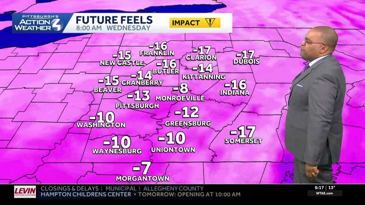
NEWS FOUR. COLD WEATHER CONTINUES AS WE HEAD INTO THE WEEKEND, WILL BE ON IMPACT DAYS TOMORROW AND THURSDAY AS AGAIN, WINDCHILLS, ESPECIALLY IN THE MORNING, WILL BE IN THE SINGLE DIGITS EITHER SIDE OF ZERO. FRIDAY AND SATURDAY, WE WILL GO BACK TO SEVERE WEATHER ALERT DAYS, AS WE COULD SET RECORD LOW TEMPERATURES FOR PITTSBURGH BOTH MORNINGS AND WIND CHILLS, ESPECIALLY SATURDAY, COULD BE THE COLDEST THEY’VE BEEN SO FAR. COLD WEATHER ADVISORIES UP FOR EVERYBODY TONIGHT. THIS GOES INTO EFFECT AT THE TOP OF THE HOUR, AND THIS WILL LAST INTO TOMORROW MORNING. WIND CHILLS WILL BE BETWEEN ABOUT TEN AND 15 DEGREES BELOW ZERO AS YOU WAKE UP TOMORROW MORNING. AIR TEMPERATURES ARE HOLDING PRETTY STEADY IN THE TEENS. WE HAVEN’T BUDGED MUCH THROUGH THE AFTERNOON, BUT WIND CHILLS ARE SITTING IN THE SINGLE DIGITS A COUPLE DEGREES. EITHER SIDE OF ZERO FEELS LIKE THREE BELOW IN INDIANA, MONROEVILLE AS WELL AS IN BUTLER, TWO BELOW IN FRANKLIN. FEELS LIKE IT’S ONE RIGHT NOW IN WASHINGTON, IT FEELS LIKE TWO FOR GREENSBURG AS WELL AS THE CITY. AS WE CONTINUE THROUGH THROUGH THE NIGHT. TONIGHT AGAIN, WIND CHILLS TOMORROW MORNING WILL BE BETWEEN ABOUT TEN AND 15 DEGREES BELOW ZERO. VERY COLD START, ESPECIALLY IF KIDS ARE HEADING OUT THE DOOR FOR THE FIRST TIME THIS WEEK, TOMORROW MORNING. AND THEN WIND CHILLS WILL SLOWLY GET BETTER THROUGH THE DAY BACK TOWARDS ZERO, AS WE’VE SEEN TODAY. AND THEN AGAIN, WIND CHILLS DROP AS WE HEAD INTO THURSDAY MORNING. WE’LL SEE WIND CHILLS BETWEEN ABOUT EIGHT AND 12 DEGREES BELOW ZERO THURSDAY MORNING BEFORE AGAIN IMPROVEMENT AS WE CONTINUE THROUGH THE AFTERNOON. WE’RE ALSO WATCHING A CLUSTER OF SOME SNOW SQUALLS MOVING OUT OF OHIO. SNOW SQUALL WARNINGS ARE UP AGAINST THE BORDER BETWEEN OHIO AND PENNSYLVANIA. WE’LL WATCH THIS AS IT ARRIVES. IF YOU DO SEE THESE SNOW SQUALLS, IT WILL REDUCE VISIBILITY BRIEFLY AND ALSO COULD DUMP A QUICK HALF AN INCH OR SO OF SNOW. BUT THESE ARE QUICK MOVING AND WEAKENING AS THEY APPROACH. BUT IT’S SOMETHING WE’LL BE WATCHING. 13 IS YOUR HIGH TEMPERATURE TOMORROW. WE’LL START AT ONE BELOW 15 ON THURSDAY, 12 ON FRIDAY WE WILL START AT SEVEN BELOW. THAT WOULD BREAK OUR RECORD. SATURDAY WILL START AT SIX BELOW. THAT WOULD ALSO BREAK THE RECORD. BUT WIND CHILLS COULD BE TERRIBLE. WE COULD BE TALKING 20 TO 30 DEGREES BELOW ZERO ACROSS ALL OF WESTERN PENNSYLVANIA. VERY COLD AIR IN PLACE. THAT WILL BE THE COLDEST WIND CHILLS HAVE BEEN SO FAR THIS WINTER SEASON. AND THEN WE START HEADING IN THE RIGHT DIRECTION. 17 IS YOUR HIGH ON SUNDAY, 24 ON MONDAY, BACK TOWARDS 30 AS WE HEAD TOWARDS NEXT TUESDAY AND WEDNESDAY. BUT OUR LOW TEMPERATURES STAY TOWARDS THE SINGLE DIGITS. WE DO HAVE CLOUDS OUT THERE ON ACTION. CAM 14 IS THE CURRENT TEMPERATURE AT PITTSBURGH. INTERNATIONAL WINDS GUSTING TO 20MPH. AGAIN, IF YOU’RE HEADING OUT TOMORROW MORNING, MAKE SURE YOU BUNDLE UP WHEN CHILLS WILL BE
Pittsburgh: Record cold possible to end the week
The extreme cold will carry us through the weekend with a slew of Alert and Impact Days.

Updated: 6:26 PM EST Jan 27, 2026
This week features several Severe Weather Alert Days (Friday and Saturday) and Impact Days (Wednesday and Thursday) for the downright frigid conditions.Cold Weather Advisory A Cold Weather Advisory is in place for the region, kicking in at 7 p.m. tonight through 11 a.m. Wednesday. Tomorrow morning’s wind chills could drop as low as -10° to -15°.Impact Days: More cold and some sunshineWednesday and Thursday are Impact Day. High temperatures will be in the mid-teens with morning wind chills between -15° and 0°. Clouds will hang tough with scattered flurries tomorrow, but Thursday should be little brighter.Severe Weather Alert Days: Record lows possibleUnfortunately, this cold air is here to stay. The Arctic air will keep morning temperatures a couple degrees either side of zero and highs in the teens all week long. A fresh delivery of Arctic air arrives ahead of the weekend. We will go back to Severe Weather Alert Days for Friday and Saturday. Pittsburgh could challenge record low temperatures both days – both records are -5° set in 2019. Afternoon highs will only manage the lower teens.At this time, a weekend coastal storm looks to stay far enough east that the Pittsburgh area won’t see any impacts. We will continue to monitor the track. Temperatures will remain below freezing for early February. But instead of the teens, highs will be in the 20s.TONIGHT – Severe Weather Alert Day: Scattered light snow before midnight. Mostly cloudy with wind chills of 10 to 15 degrees below zero. Low: -1°.WEDNESDAY – Impact Day: Mostly cloudy, blustery and very cold. High: 13°, low: 2°.THURSDAY – Impact Day: Bitterly cold with limited sunshine. High: 15°, low: -7°.
PITTSBURGH —
This week features several Severe Weather Alert Days (Friday and Saturday) and Impact Days (Wednesday and Thursday) for the downright frigid conditions.
Cold Weather Advisory
A Cold Weather Advisory is in place for the region, kicking in at 7 p.m. tonight through 11 a.m. Wednesday. Tomorrow morning’s wind chills could drop as low as -10° to -15°.

Impact Days: More cold and some sunshine
Wednesday and Thursday are Impact Day. High temperatures will be in the mid-teens with morning wind chills between -15° and 0°. Clouds will hang tough with scattered flurries tomorrow, but Thursday should be little brighter.
Severe Weather Alert Days: Record lows possible
Unfortunately, this cold air is here to stay. The Arctic air will keep morning temperatures a couple degrees either side of zero and highs in the teens all week long. A fresh delivery of Arctic air arrives ahead of the weekend. We will go back to Severe Weather Alert Days for Friday and Saturday. Pittsburgh could challenge record low temperatures both days – both records are -5° set in 2019. Afternoon highs will only manage the lower teens.

Hearst Owned
Record cold is possible Friday and Saturday mornings. Friday morning is likely the colder day of the two.
At this time, a weekend coastal storm looks to stay far enough east that the Pittsburgh area won’t see any impacts. We will continue to monitor the track. Temperatures will remain below freezing for early February. But instead of the teens, highs will be in the 20s.

Hearst Owned
Cold, record cold, then a slight warming trend.
TONIGHT – Severe Weather Alert Day: Scattered light snow before midnight. Mostly cloudy with wind chills of 10 to 15 degrees below zero. Low: -1°.
WEDNESDAY – Impact Day: Mostly cloudy, blustery and very cold. High: 13°, low: 2°.
THURSDAY – Impact Day: Bitterly cold with limited sunshine. High: 15°, low: -7°.