
Another system will send two rounds of showers through the Pittsburgh area – the first arrives mid-morning and the second this evening.Two batches of showers todayClouds will quickly take over this morning. The first round of showers arrives as early as 9 a.m. or 10 a.m. The rain will be relatively light. It will be soggy if you’re heading out to grab lunch. This round exits east by 1 p.m. or 2 p.m. The remainder of the afternoon will be dry.The more “impactful” wave will cross between 6 p.m. and 9 p.m. Pops of locally heavy rain along with gusty winds up to 40 or 45 mph are possible. A few straggling showers will linger through midnight. Outside of a stray shower near I-80, Wednesday begins another dry stretch.Windy stretch of daysEven outside of this evening’s gusty showers, it will be another breezy day. Westerly winds will gust close to 25 mph this afternoon.The wind will have a little more “gusto” tomorrow with some peak gusts closer to 35 or 40 mph. It will be a good idea to keep our outdoor furniture and decor tied down.Brisk, November-like air through the weekendThis latest system will draw in even cooler air for the rest of the week. Highs will drop from the lower 60s today to only around 50 degrees Wednesday. There is a frost potential Friday morning.Temperatures will gradually warm through the 50s over the weekend. The dry stretch will extend through at least Saturday. We are watching a shower potential for Sunday and how it could impact tailgating and the Steelers game under the lights on the North Shore.TODAY: Breezy with two batches of isolated showers. High: 62°.TONIGHT: Showers fizzle with lingering clouds. Low: 42°.WEDNESDAY: Blustery and much cooler. Clouds with stray shower north. High: 52°, low: 40°.THURSDAY: Brisk with sun and clouds. High: 53°, low: 36°.
PITTSBURGH —
Another system will send two rounds of showers through the Pittsburgh area – the first arrives mid-morning and the second this evening.
Two batches of showers today
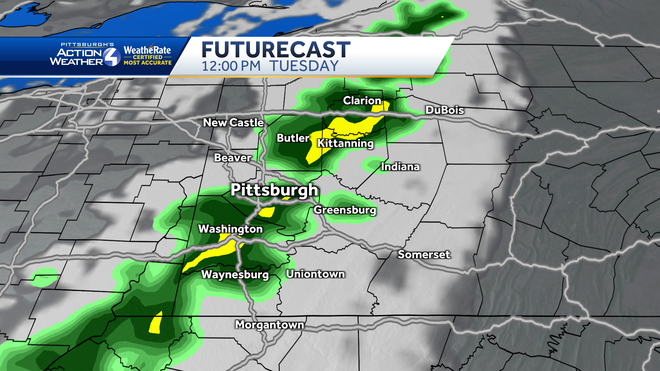
Clouds will quickly take over this morning. The first round of showers arrives as early as 9 a.m. or 10 a.m. The rain will be relatively light. It will be soggy if you’re heading out to grab lunch. This round exits east by 1 p.m. or 2 p.m. The remainder of the afternoon will be dry.

Hearst OwnedHearst
Soggy around lunchtime as light rain treks around western PA.
The more “impactful” wave will cross between 6 p.m. and 9 p.m. Pops of locally heavy rain along with gusty winds up to 40 or 45 mph are possible. A few straggling showers will linger through midnight. Outside of a stray shower near I-80, Wednesday begins another dry stretch.

Hearst OwnedHearst
A cold front will spark a few gusty showers this evening. Sneaky gusts up to 40 or 45 mph are possible with isolated instances of lightning.
Windy stretch of days
Even outside of this evening’s gusty showers, it will be another breezy day. Westerly winds will gust close to 25 mph this afternoon.
The wind will have a little more “gusto” tomorrow with some peak gusts closer to 35 or 40 mph. It will be a good idea to keep our outdoor furniture and decor tied down.

Hearst OwnedHearst
Blustery Wednesday with highs around 50 degrees and wind gusts of 30 to 40 mph.
Brisk, November-like air through the weekend
This latest system will draw in even cooler air for the rest of the week. Highs will drop from the lower 60s today to only around 50 degrees Wednesday. There is a frost potential Friday morning.
Temperatures will gradually warm through the 50s over the weekend. The dry stretch will extend through at least Saturday. We are watching a shower potential for Sunday and how it could impact tailgating and the Steelers game under the lights on the North Shore.

Hearst OwnedHearst
November-like days are ahead with highs only in the 50s through the weekend.
TODAY: Breezy with two batches of isolated showers. High: 62°.
TONIGHT: Showers fizzle with lingering clouds. Low: 42°.
WEDNESDAY: Blustery and much cooler. Clouds with stray shower north. High: 52°, low: 40°.
THURSDAY: Brisk with sun and clouds. High: 53°, low: 36°.