
GOOD MORNING. WE ARE STILL UNDER THE INFLUENCE OF NORTHWESTERLY FLOW. AND THAT DEEP UPPER LEVEL TROUGH SETTLED OVER THE EAST COAST, AND THAT’S ALLOWING FOR THAT ARCTIC AIR MASS TO JUST CONTINUE TO REMAIN IN PLACE. TEMPERATURES RIGHT NOW WE HAVE NINE DEGREES IN LEWISTOWN, 14 IN CARLISLE, 12 IN CHAMBERSBURG AND HARRISBURG, 13 IN LANCASTER. THE WINDS, HOWEVER, KEEPING THEY’VE BEEN MUCH STRONGER. BUT NOW STARTING TO LIGHTEN UP A BIT, ABOUT 5 TO 10MPH MAKES IT FEEL LIKE THREE BELOW IN LEWISTOWN, ONE DEGREES BELOW IN HARRISBURG, ZERO CHAMBERSBURG AT FOUR. IN LANCASTER. AS WE LOOK AT THE TEMPERATURE AND WIND CHILL, WE’LL SEE TEMPERATURES DROPPING OFF A FEW MORE DEGREES INTO THE SINGLE DIGITS AND LOW TEENS. THAT MEANS THE FEELS LIKE TEMPERATURES WILL ALSO BE DROPPING HEADING INTO THE AFTERNOON. HIGHS RIGHT AROUND 20 DEGREES WITH FEELS LIKE TEMPERATURES STAYING IN THE SINGLE DIGITS. NOW WE START OFF WITH SOME SUNSHINE, BUT I DO EXPECT THE SKIES TO CLOUD UP AS WE HEAD INTO THE AFTERNOON.
IMPACT WEEK | Arctic cold lingers with blustery winds in south-central Pa.

Updated: 5:18 AM EST Jan 28, 2026
The Susquehanna Valley remains in a stretch of arctic cold with bitter winds and frigid temperatures. A cold weather advisory is in effect for all of south-central Pennsylvania until 10 a.m. Wednesday. It started at 7 p.m. Tuesday and is the second one to be issued by the National Weather Service this week. Wednesday’s forecastBlustery winds: Wind chills below zero due to a 5-15 mph breeze. Temperatures: Highs reach 20 degrees with sunshine in the morning and clouds in the afternoon. Impact WeekThe WGAL News 8 Storm Team declared Tuesday through Saturday Impact Days as a prolonged blast of extreme cold grips the Susquehanna Valley.The National Weather Service issued a third cold weather advisory this week for the entire Susquehanna Valley, in effect from 1 a.m. to 10 a.m. Thursday. This pattern will likely recur every day this week.Record-breaking temperaturesWith wind chills in the single digits and below zero, the Susquehanna Valley could challenge, and possibly break, several record lows this week. Wednesday morning: The record low is -1, set in 1935.Thursday morning: The record low is -4, set in 1963.Friday morning: The record low is 2, set in 2014.Saturday morning: The record low is 2, set in 1948.SOUTH-CENTRAL PA WEATHER RESOURCES: INTERACTIVE RADAR | ACTIVE WEATHER ALERTS | CURRENT CONDITIONS | HOURLY FORECAST | 10-DAY FORECAST | WEEKEND FORECAST | MAP ROOM | DOWNLOAD THE APP | WEATHER EMAILS
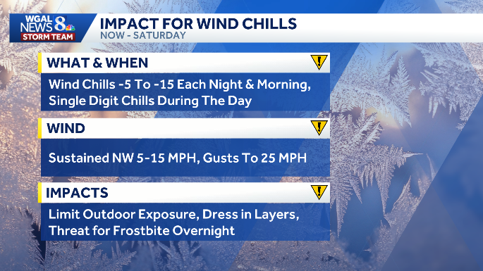
The Susquehanna Valley remains in a stretch of arctic cold with bitter winds and frigid temperatures.
A cold weather advisory is in effect for all of south-central Pennsylvania until 10 a.m. Wednesday. It started at 7 p.m. Tuesday and is the second one to be issued by the National Weather Service this week.

Wednesday’s forecast
Blustery winds: Wind chills below zero due to a 5-15 mph breeze.
Temperatures: Highs reach 20 degrees with sunshine in the morning and clouds in the afternoon.

Impact Week
The WGAL News 8 Storm Team declared Tuesday through Saturday Impact Days as a prolonged blast of extreme cold grips the Susquehanna Valley.
The National Weather Service issued a third cold weather advisory this week for the entire Susquehanna Valley, in effect from 1 a.m. to 10 a.m. Thursday.
This pattern will likely recur every day this week.


Record-breaking temperatures
With wind chills in the single digits and below zero, the Susquehanna Valley could challenge, and possibly break, several record lows this week.
Wednesday morning: The record low is -1, set in 1935.Thursday morning: The record low is -4, set in 1963.Friday morning: The record low is 2, set in 2014.Saturday morning: The record low is 2, set in 1948.

SOUTH-CENTRAL PA WEATHER RESOURCES: INTERACTIVE RADAR | ACTIVE WEATHER ALERTS | CURRENT CONDITIONS | HOURLY FORECAST | 10-DAY FORECAST | WEEKEND FORECAST | MAP ROOM | DOWNLOAD THE APP | WEATHER EMAILS