

Forecasters continue to monitor another major winter storm that could bring snow to the Lehigh Valley for the third weekend in a row.
Meteorologists are increasingly confident that a nor’easter will hit the Carolinas this weekend, but they are not clear what, if any, impacts it might have on eastern Pennsylvania and surrounding regions.
❄️ Winter Storm Likely This Weekend ❄️
Confidence has increased, particularly across the Carolinas and southern Virginia, for impactful snowfall beginning as early as Friday night. More uncertainty remains for areas north along the East Coast. Stay tuned for more updates! pic.twitter.com/KT1UiNH6Dy
— NWS Weather Prediction Center (@NWSWPC) January 28, 2026
The National Weather Service in Mount Holly, New Jersey, released a map on Wednesday showing the Allentown area with just a 19% chance of 4 inches of snow or more through Sunday. Areas south and east of the region have a higher likelihood, but still under 50%.
Meteorologists wrote in their daily forecast discussion that impacts hinge on the exact track of the storm, which is still uncertain. One forecast model showed the storm trending west, while the other showed it trending east.
“So this all said, it boils down to whether the storm tracks farther northward along the coast before turning east (bringing the area greater impacts) vs. being quicker to turn east meaning the track would stay farther away bringing more limited impacts,” they said.
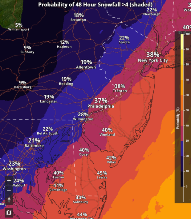 This map from the National Weather Service shows the probability of snowfall greater than 4 inches over the weekend.
Impacts could include heavy precipitation and high winds. The earliest a potential storm could arrive is late Saturday into Sunday. Forecasters noted that because of very cold temperatures, any precipitation would be all snow. Regardless of how it tracks, it will likely bring high winds to the region, according to the weather service.
The exact details on the storm’s impact should become more clear over the next few days, forecasters said.
This potential storm comes during a particularly snowy January. So far 20.8 inches of snow has fallen this month, making it the snowiest January in a decade. There has been more snow this month alone than the entirety of last winter.
Outside of the potential weekend storm, the next several days will continue to be dangerously cold, with highs below freezing and some lows in the single digits or below zero. The Lehigh Valley is under a cold weather advisory until 10 a.m. Thursday.
Here is the extended forecast from the National Weather Service:
Thursday: Mostly sunny, with a high near 19. Wind chill values as low as -13. West wind 5 to 10 mph, with gusts as high as 20 mph.
Friday: Sunny, with a high near 17. West wind 5 to 10 mph, with gusts as high as 20 mph.
Saturday: Partly sunny, with a high near 19.
Sunday: Mostly cloudy, with a high near 23. Blustery.
Monday: Partly sunny, with a high near 31.
Tuesday: Partly sunny, with a high near 30.